 
Little_buddy
Member
Username: Little_buddy
Post Number: 3
Registered: 03-2006
| | Posted on Sunday, April 15, 2007 - 9:02 pm: |    |
Back in the mid-70's went fishing on an old ship canal around the south end of Grosse Ile. It had a narrow entrance and maybe a quarter mile long and not very wide, high banks and at the back was a fresh,clear,spring of water that you could see down 20ft, see the fish and all. Anyone know what I am talking about. |
Ndavies
Member
Username: Ndavies
Post Number: 2547
Registered: 10-2003
| | Posted on Sunday, April 15, 2007 - 9:33 pm: | |
Crystal bay maybe? |
Dan
Member
Username: Dan
Post Number: 1379
Registered: 10-2003
| | Posted on Sunday, April 15, 2007 - 10:08 pm: | |
Ndavies is correct.
You are most likely talking about Crystal bay, which is attached to the shipping channel that runs parallel to GI, about a half mile off the Canadian shore.
The banks are high from the materials dredged from the channel, which makes the islands there very rocky. Tiny campsite dart the area. |
Gannon
Member
Username: Gannon
Post Number: 8944
Registered: 12-2003
| | Posted on Sunday, April 15, 2007 - 10:36 pm: | |
Yeah, back in 97-98, I ran a jetski on the river...we went back to the areas off Crystal Bay after the fishermen were done for the morning, it was some of the best water for high-speed runs...very smooth.
In the back areas, even further isolated coves where the fishermen would do their do, there was an old pickup truck that sunk when the ice wasn't thick enough...you could see it about fifteen or twenty feet down.
Cheers! |
Sstashmoo
Member
Username: Sstashmoo
Post Number: 67
Registered: 02-2007
| | Posted on Monday, April 16, 2007 - 5:14 pm: | |
That's "Livingstone channel" and yes Crystal Bay. Which is about impossible to go to anymore, thanks to terrorism and the US partyers pretending it was in US waters. They painted the rocks on shore with graffiti, burned boats, etc. The OPP doesn't want any US boats there now or so I've heard. The mutli-million dollar "cottages" on the north end of Bois Blanc (faces Crystal bay) probably had some say in it as well.
I heard one account that Canada warned if anymore boats got burnt and allowed to sink, they were going to tighten down. Another boat got burnt as usual at the end of boating season, the debris sank into the crystal clear waters, party is over. Now they all congregate behind a levee on the US side. |
Mikem
Member
Username: Mikem
Post Number: 3262
Registered: 10-2003
| | Posted on Monday, April 16, 2007 - 7:55 pm: | |
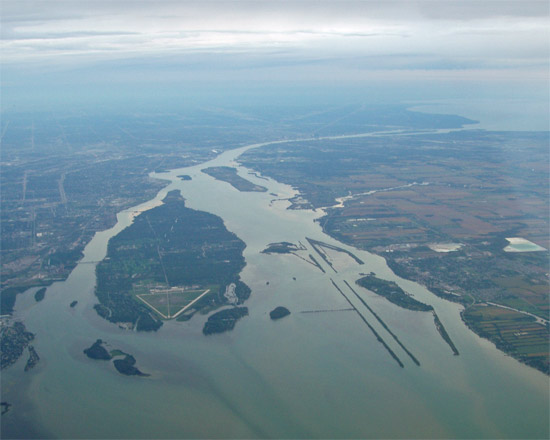
|
Harsensis
Member
Username: Harsensis
Post Number: 256
Registered: 07-2005
| | Posted on Tuesday, April 17, 2007 - 8:58 pm: | |
There are some springs like that on the St Clair River at Harsens Island too. You can't see down into them, but the water gets really smooth where the springs surface. While rafting in the St Clair River I have seen some ship wrecks under the water though. |
The_rock
Member
Username: The_rock
Post Number: 1710
Registered: 11-2003
| | Posted on Wednesday, April 18, 2007 - 7:08 am: | |
Nice shot Mikem. My cousin out in California might have had somewhat the same view in the '40s when he flew his Stearman PT-17 into the Naval base there.
He learned to fly that plane in Kansas in January. Open air cockpit. Talk about COLD!! |
Little_buddy
Member
Username: Little_buddy
Post Number: 8
Registered: 03-2006
| | Posted on Wednesday, April 18, 2007 - 11:02 am: | |
That is a great picture. Thanks alot. Any more photos of the Detroit area from the air? |