Al_t_publican Member Username: Al_t_publican Post Number: 137 Registered: 06-2004 |
An earlier post about Balduck Park hill on the NE side near St. John Hospital got me to wondering about what the geographic hight point was in Detroit. If I recall right, Detroit ranges from about 560 feet to about 640 feet above sea level. I'm guessing the highest point in the city is on the west side somewhere between Fenkell and Eight Mile between Lahser and Telegraph or along Mound Rd. near Eight Mile. Also, what is the highest point in SE Mich, not counting man-made hills like Balduck and ski hills like Brighton? | ||
Jimaz Member Username: Jimaz Post Number: 1436 Registered: 12-2005 |
I happen to be looking for a good source of online topo maps. That would help. Is there any way to get Google Earth to show isopleths? | ||
Mikeg Member Username: Mikeg Post Number: 506 Registered: 12-2005 |
Topographic maps available here (PDF) indicate: Balduck Park: 585 ft. above sea level Balduck Park (top of hill): 605 ft. Northwest Detroit (vicinity of Norfolk abd Grandview): 640 ft. The highest elevations (+670 ft.) appear to be in an approximately half-mile wide area bounded on the north by Eight Mile (between Indiana on the west and Santa Barbara on the east) running in a southwesterly direction down to the area by Grace Hospital. The highest recorded benchmark elevation within that area is 672 ft. at the intersection of Wyoming and Pembroke. USGS Topo maps for the entire state are available here. | ||
Mackinaw Member Username: Mackinaw Post Number: 2368 Registered: 02-2005 |
If we limit SE Michigan to Detroit and all the counties that border on Wayne, some of the higher points are the north side side of Ann Arbor i.e. Huron/Liberty west of Main St., and the bluffs along the Huron River, which, I believe, rise as high as 930 feet. The highest points are, I think, a few points in central Oakland county that rise to as high as 1050 feet, right around White Lake and the Highland Rd. part of M59. It's 500 feet higher than downtown Detroit, but it is such a gradual rise. The highest point in Detroit needs to be near the Ferndale or Redford boundaries, simply because these points are the furthest from the river. The only places in Detroit where you really see inclines of more than 10-20 feet in one place, to give the sense of having terrain, are a few places on the lower east side (some of roads leading south from Jefferson to the river, or slight the hill on McClellan from Kercheval to Jefferson), and neighborhoods built near the Rouge/Rouge tribituaries on the far west side i.e. Brightmoor. Grosse Pointe Farms has a ridge right in the middle of the city that sits about 30 feet higher than the rest of the city. It is an old beach ridge from the days when Lake St. Claire was larger, and you can drive up it on streets like Touraine, Stephens, and Moran between Charlevoix and Ridge. Ridge Road rises about 20-30 feet near Richard School from Fisher Rd. to Lewiston, as does Kercheval. There are also small bluffs right along Lakeshore Dr. in GPF. The lowest point in the city is Zug Island. | ||
Fareastsider Member Username: Fareastsider Post Number: 59 Registered: 08-2006 |
I believe that Mt. trombley in Bruce Twp is the highest point in SE MI. The Bruce Twp website says it is the highest point for 100 miles. I can not find an exact elevation though. Mt Trombley is in the Ford Proving Grounds | ||
Mackinaw Member Username: Mackinaw Post Number: 2369 Registered: 02-2005 |
I have never, ever heard of Bruce Twp. I'm guessing it's in northern Macomb? | ||
Jimaz Member Username: Jimaz Post Number: 1437 Registered: 12-2005 |
Thanks, Mikeg. That's exactly what I needed. | ||
Jimaz Member Username: Jimaz Post Number: 1438 Registered: 12-2005 |
There's a spot at 1,214ft in far northern Oakland County according to Google Earth. It's near 42°51'57"N 83°12'38"W . | ||
Ray1936 Member Username: Ray1936 Post Number: 1088 Registered: 01-2005 |
Mackinaw, yes, Bruce Twp. is in the Romeo area. For what it's worth, my house is at 2,950 feet above sea level. I fear not for global warming. | ||
Dodgemain Member Username: Dodgemain Post Number: 137 Registered: 04-2005 |
Mt Trombly is 1100 ft. It is in the Ford test track. | ||
Lowell Board Administrator Username: Lowell Post Number: 3623 Registered: 10-2003 |
I seem to recall from a nautical map that Detroit 'sea level' is 581'. Of course that would fluctuate with the lake levels, but it makes me curious if there are any spots 'below sea level'. | ||
Gistok Member Username: Gistok Post Number: 3515 Registered: 08-2004 |
One of the best spots to view metro Detroit from a higher elevation is near the circular entrance drive of Stony Creek Metropark at 26 Mile Rd. Since we're on the topic.... what is that mountain of dirt behind the Palace of Auburn Hills going to be? It's huge! | ||
Jimaz Member Username: Jimaz Post Number: 1440 Registered: 12-2005 |
quote:Yeah, on a clear day RenCen is visible but it's way distant. Bring your own binoculars because the pay-per-view binoculars there at the office have been removed. There are higher points in Stony Creek Metropark according to GPS. | ||
Yaktown Member Username: Yaktown Post Number: 98 Registered: 02-2006 |
Gistok, are you referring to the landfill just north of the Palace? ;-) I think it's going to be trash for a long time. | ||
Fareastsider Member Username: Fareastsider Post Number: 61 Registered: 08-2006 |
you can also see the ren cen if you know where to look at that high point on Lapeer road just north of the palace. | ||
Spiritofdetroit Member Username: Spiritofdetroit Post Number: 196 Registered: 11-2006 |
really? wow | ||
Gianni Member Username: Gianni Post Number: 275 Registered: 05-2004 |
The highest point in Wayne County is somewhere near Schoolcraft College at 8 and Haggerty. You can see the Ren Cen from there. Glacial moraine. | ||
Jjaba Member Username: Jjaba Post Number: 4784 Registered: 11-2003 |
Mt. Arvon, 1,979 Ft., highest Point in Michigan. Baraga County, northwestern UP. jjaba, on the Westside, growing up thought the sled runs at Rouge Park were mountains. Then one summer his parents drove him through Colorado. | ||
Gistok Member Username: Gistok Post Number: 3518 Registered: 08-2004 |
Jjaba is correct... although in the past the previous highest point was deemed to be Mt. Curwood at 1,980 feet. I wonder if erosion set in on Mt. Curwood? Or with modern satellite systems, they probably determined that Mt. Curwood was not quite as tall as they originally thought? | ||
Lmichigan Member Username: Lmichigan Post Number: 5070 Registered: 10-2003 |
Yeah, the highest point in Detroit proper is in the University neighborhood at something like 670 feet+. Another view of downtown that I'd never seen before until a few years ago was catching the top of the RenCen from 94 eastbound just before you hit 275. I thought my eyes were playing tricks on me, but I swear I could make out the top of the RenCen, Comerica, and Penobscot. | ||
Johnnny5 Member Username: Johnnny5 Post Number: 430 Registered: 06-2005 |
My parents house sits at about 1140 feet above sea level on the South side of Milford Township. I remember sitting on the roof at night and easily being able to see the lights (And the blimps during the day) from the Silverdome. Today the trees are a little taller, but I can still see Alpine Valley Ski hill as well as parts of Waterford from the house. | ||
Gistok Member Username: Gistok Post Number: 3519 Registered: 08-2004 |
There's a couple of locations like that. From the north, Mound Rd. lines up exactly with downtown with a nice view of the RenCen. Also from the west Ford Rd. in Dearborn does also, with a view of all 3 buildings. | ||
Brougham Member Username: Brougham Post Number: 3 Registered: 01-2007 |
9 mile and Haggerty, Before the developers broke ground and houses went in, you could see the ambassador bridge. | ||
Hardhat Member Username: Hardhat Post Number: 189 Registered: 10-2003 |
Below sea level? - I gotta believe that if such a spot exists, it's in Hines Park. | ||
Cmubryan Member Username: Cmubryan Post Number: 354 Registered: 11-2003 |
13 Mile and Northwestern has a beautiful view of the Detroit skyline. | ||
Burnsie Member Username: Burnsie Post Number: 839 Registered: 11-2003 |
You can see the RenCen from the northeastern corner of 13 Mile and Mound Rd. | ||
Peachlaser Member Username: Peachlaser Post Number: 54 Registered: 08-2006 |
I thought 'High land Park' was the highest spot around thus the name. Where does it rank? | ||
Gistok Member Username: Gistok Post Number: 3523 Registered: 08-2004 |
The lowest point in the state of Michigan is something like 579ft. above sea level. That would be the shore of Lake Erie. No need to worry about rising sea levels here! | ||
Mikeg Member Username: Mikeg Post Number: 512 Registered: 12-2005 |
The benchmarked elevations in Highland Park are all between 634 and 648 feet above sea level. That highest benchmarked point is at the very northwest corner of the city on McNichols at Log Cabin St. These USGS topographic maps indicate that Lake St. Clair has an approximate mean lake elevation of 575 feet above sea level. A benchmark in downtown Detroit on the banks of the Detroit River directly over the Detroit-Windsor Tunnel is 579 ft. above sea level. The map's 575 ft. countour line follows the riverbank for its entire length from downtown to Zug Island. | ||
Jjaba Member Username: Jjaba Post Number: 4787 Registered: 11-2003 |
Mikeg, you do fine work for the people. Thanks. jjaba. | ||
Mackinaw Member Username: Mackinaw Post Number: 2372 Registered: 02-2005 |
I'm told that the Elmwood Cemetary is a good example of what pre-development (and pre-farming, for that matter) Detroit looked like. It would be nice to see what other parts of Detroit looked like before development and all the land-leveling, road-building implements were utilized in the 1800s and 1900s. I'm sure the land had at least some contours before development. | ||
Jjaba Member Username: Jjaba Post Number: 4789 Registered: 11-2003 |
Mackinaw, this is correct. Early pioneers knew we'd all have to install those goddamn chains without land shaping. Nobody had front wheel drive or 4X4s back then. jjaba. | ||
Ray1936 Member Username: Ray1936 Post Number: 1089 Registered: 01-2005 |
There are places where the bottom of Lake Superior is well below sea level. Unfortunately those spots are full of water. Fortunately, it's fresh water. | ||
Mikeg Member Username: Mikeg Post Number: 513 Registered: 12-2005 |
Here is the portion of the topo map showing Elmwood and Mt. Elliott Cemeteries. 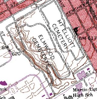 The bold contour line indicates the 600 ft. elevation level and the lighter lines are spaced at 5 ft. intervals. Accurately measured benchmarks are labeled like this, "X BM 620", meaning the "X" locates a known point that is 620 ft. above sea level. On the map, you can see that the northern portion of Mt. Elliott Cemetery has a relatively flat elevation between 615 and 620 ft., while Elmwood has a valley that has been carved by Parent's Creek (aka Bloody Run). The lowest contour line in the southern part of the valley is 585 ft. | ||
Dabirch Member Username: Dabirch Post Number: 2070 Registered: 06-2004 |
From the first tee at the Orchards in Romeo/Washington Twp., you can see the Ren Cen. It's a pretty cool sight being out in the sticks and all. | ||
Jjaba Member Username: Jjaba Post Number: 4794 Registered: 11-2003 |
Dabirch, good work. 2000 posts. Mazel tov. Enjoy your golf game. jjaba, walker. | ||
Gmich99 Member Username: Gmich99 Post Number: 160 Registered: 11-2005 |
The Detroit skyline is visible at night (as are the fireworks) from the old Northville high school at 8 Mile and Center Street in Wayne County. | ||
321brian Member Username: 321brian Post Number: 313 Registered: 02-2006 |
The Detroit skyline can also be seen by the new Troy High on driving east on Long Lake. Very cool with the Troy buildings in the front. |