Fareastsider Member Username: Fareastsider Post Number: 292 Registered: 08-2006 |
I just noticed something I never caught before.. For all the boater out there just on the Canadian side of the border there is an island called Seaway Island that is part of indian land. This island is in the Saint Clair Flats along the South Channel. I was looking at some old maps care of a link provided by Mikem and noticed that Seaway didnt exist except for small islands before 1959. on the 1959 map there is a new canal being dredged which is the current shipping channel. Is seaway the result of them dumping this dredged land? it must be, but i am wondering if anyone has any idea? Im sure lots of small islands have been made in the flats by filling in some swamp but I have never known of it on this level. here is the link for anyone curious about old Lake Saint Clair maps... http://historicals.ncd.noaa.go v/historicals/histmap.asp | ||
Mikem Member Username: Mikem Post Number: 3232 Registered: 10-2003 |
The Corps has continuously struggled to keep the Flats open to shipping since before the Civil War. Money appropriated for dredging the channel in 1852 was used up building the dredge itself. Out of money and with further funding bogged down in Washington and Army politics, it was 1856 before another attempt was made at deepening the channels (using money raised by Buffalo merchants). The Flats and the St Mary's River were probably the two main obstacles to shipping in the upper lakes. I think work on the cut-off was started in 1955. The island was built up using the dredging wastes, but it's not as if there wasn't anything there before: 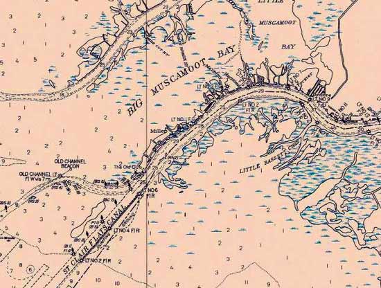  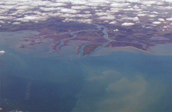 | ||
Gistok Member Username: Gistok Post Number: 3999 Registered: 08-2004 |
It is interesting to note that you could not easily see the channel islands from Grosse Pointe Shores Lakeshore Drive until the lake levels dropped a few years ago. Now on clear days, you can see them just to the right of the Grosse Pointe Yacht Club tower, when driving northbound on that stretch of Lakeshore Dr. | ||
Jjaba Member Username: Jjaba Post Number: 5117 Registered: 11-2003 |
Thanks MikeM for the beautiful photos from the jet cockpit. jjaba. | ||
Taj920 Member Username: Taj920 Post Number: 203 Registered: 01-2004 |
Is Seaway island considered American or Canadian soil or both? | ||
Danny Member Username: Danny Post Number: 5718 Registered: 02-2004 |
Some parts of Seaway Island are part of Canada, But its close to Michigan it should be belong to our state. Give back our Island Canada! | ||
Gistok Member Username: Gistok Post Number: 4002 Registered: 08-2004 |
Didn't someone on another thread say that this was the worlds largest freshwater delta? | ||
Irish_mafia Member Username: Irish_mafia Post Number: 849 Registered: 10-2003 |
Gistok, I remember being able to see the flats from GP on a clear day since I was a kid.... and that was a long time ago. | ||
Gistok Member Username: Gistok Post Number: 4003 Registered: 08-2004 |
I think that during low water years they are easier to see. Plus you have to be looking in the correct spot on the horizon, because they are so distant. | ||
Irish_mafia Member Username: Irish_mafia Post Number: 853 Registered: 10-2003 |
and if you look too closely at the horizon, you may hit a pedestrian on the way to mass at St. Pauls with your car... | ||
Fareastsider Member Username: Fareastsider Post Number: 293 Registered: 08-2006 |
Seaway is Canadian land. The South Channel which runs along the west end of the island is the border. Did anyone ever see an article in the paper a few years ago that showed a plan from the fifties that some guy planned to build 5,000 homes on Lake Saint Clair. By running roads such as 8 mile to swing towards Harsens Island, and from 16 to Harsens island with a whole bunch of islands that were man made. He basically wanted to build a whole bunch of islands connected by roadways accross the lake! Of course it was never built. Anyone know about this strange plan? | ||
Harsensis Member Username: Harsensis Post Number: 207 Registered: 07-2005 |
I remember something about that, but not much. What I remember is seeing a map from the earlier 1900's of a connection they were going to make from 16 mile to Harsens Island by interurban railway. I don't remember where I saw this, but it might have been at the Mt Clemens Museum. Even though the channel along Seaway Island is totally in Canada, we take our waverunners down it all of the time and have never had a problem. The cops hang out more in the old channel by Gull Island and the US Coast Guard just waves at us when we go past them. | ||
Goat Member Username: Goat Post Number: 9332 Registered: 10-2003 |
It is Native land (Canada or U.S.) a part of the Walpole First Nation. | ||
Gistok Member Username: Gistok Post Number: 4012 Registered: 08-2004 |
LOL at Irish_mafia's comment... although I shouldn't laugh too loud... I did take out a bicyclist at Moran and Lakeshore Dr. in 2003 (I was driving down Moran and stopped at the Lakeshore stop sign, she was pedaling northbound Lakeshore on the southbound sidewalk). The good news is that she landed (with her bike) on the hood of my car, and I was so shocked that I hit the gas, and luckily when she fell of, it was on the grassy medium island, without sustaining any injuries... although her bike was a wreck. When the Farms police got to the scene, she told him that I did come to a complete stop (which I did). But that cement berm (holding back the lawn (about 7 feet higher than the street level) of the Grosse Pointe Academy property) prevented me from seeing any pedestrians or bikers until the nose of my car was already past the sidewalk. A lady in a stroller was bitching at the officer that this was the 2nd accident in 5 days that she saw at this intersection, the other was a jogger. I did not receive a ticket, but one later got mailed to me. I went to court to fight it, but the judge didn't care. I told him that if Grosse Pointe Farms cared about their residents safety that they would force the Academy to lower that berm. I still had to pay, but it was worth the bitching I did, and 2 years later GPF finally did lower that berm... but I wonder what the final cost was in injuries due to their ineptly slow response. Sorry to threadjack... | ||
Fareastsider Member Username: Fareastsider Post Number: 296 Registered: 08-2006 |
Well you can see Detroit from the flats.... http://i141.photobucket.com/al bums/r50/fareastsider/Detroit3 .jpg | ||
Bob_cosgrove Member Username: Bob_cosgrove Post Number: 488 Registered: 03-2005 |
The old south channel was known as "The Serpent" because of the way it round around. Bob Cosgrove | ||
Bibs Member Username: Bibs Post Number: 683 Registered: 10-2003 |
If you have a chart of Lake St. Clair, the border runs down the Old South Channel and then right along the shore of Seaway Island. These is a shallow canal, then a rock pile and then the South Channel. The area that I'm talking is right across from Gull Island. The US and Canadian Border runs right down this small channel and then follows the shipping channel out into Lake St. Clair. This small spit of land was the former site of the Old Club which is a yacht club now on Harsens Island. The Old Club burned down in 1919 I believe. The Army Corp has built up Gull Island with dredge material as well. On the Eastern shore of Seaway Island along the cut off channel they have large retention basins about a foot ball field in length, lined with a material to filter water and large boulders frame the edge When they dredge the channel they pump the water and sediment into these basins and the water eventually filters out. | ||
Harsensis Member Username: Harsensis Post Number: 214 Registered: 07-2005 |
Gull Island from what I understand is from one of the old lighthouse piers that they removed when they widened the South Channel. There use to be two lighthouses there and they burned them and dug out the channel depositing it where Gull Island is today. | ||
Fareastsider Member Username: Fareastsider Post Number: 299 Registered: 08-2006 |
2 other lights besides the current South Channel lighthouses? | ||
Tigers2005 Member Username: Tigers2005 Post Number: 116 Registered: 02-2005 |
The South Channel lights are still there. They are range lights that marked the original course of the South Channel, which came down along the east side of Harsen's, around the west side of what is now Seaway Island and then around what is now Gull Island. Groups have been working to restore the condition of the lights in recent years and some work has been done on the shorter front light (farther south), which has a lean that looks like a short version of the Leaning Tower of Pisa. | ||
Harsensis Member Username: Harsensis Post Number: 218 Registered: 07-2005 |
Yes, there were two other lighthouses along what was called the piers. The lighthouses that are there now only remain because they were not in the way of the new outlet. Those were the early lighthouses. When they straightened the channel they made a narrow chute called the piers to make the trip to Detroit safer. But in the 1930's the ship started getting bigger and the old channel was to narrow, so that is when they took those lighthouses down and widened the channel to the width it is today. Then in the 1960's they bypasses the south channel with the seaway cut. The original plans had the seaway cut going right through Harsens Island, but it was easier to do it where there were not any houses to deal with and buy out. I haven't figured out if both lighthouses were on the same side of the pier or of they were on opposite sides, because there is a big cement base across the river from the old club. I think there is a lagoon across from the old club too, but I have never ventured in there since I didn't want to get to shallow with my waverunner. Plus I had to sell my waverunner, so now I have to wait to get another one after I find a real job. Then I can check it out again. | ||
Tigers2005 Member Username: Tigers2005 Post Number: 122 Registered: 02-2005 |
Thanks for the great info, Harsensis. I have been going out on the flats my whole life and I love the history out there. My relatives have an island out on the Sni. I spend every weekend in the summer out on the flats. | ||
Harsensis Member Username: Harsensis Post Number: 222 Registered: 07-2005 |
Cool Tigers, I love the history there too. I can't believe how many different postcards there are of that place. I will get the lighthouses scanned and posted on here from the piers I'm talking about. Then you'll be able to see it. | ||
Fareastsider Member Username: Fareastsider Post Number: 315 Registered: 08-2006 |
I wish I had a house on one of them islands in the flats. | ||
Southwestmap Member Username: Southwestmap Post Number: 772 Registered: 01-2005 |
We had a cottage in Algonac. The club on Harsen's island at the Flats was the Old Club still (then). I think Manny Moroun has a place there. | ||
Mikem Member Username: Mikem Post Number: 3233 Registered: 10-2003 |
If I have my history right, the old channel was the original shipping channel, marked by the range lights, the larger of which is the object of a preservation effort: http://lighthouse.boatnerd.com/gallery/StClair/southchannel.htm http://www.lighthousedepot.com/database/dataphotopage.cfm?value=513 I never knew it had an attached dwelling for the light keeper. In 1871 the Corps dredged the south channel to extend it into the lake and built dikes on each side to keep it from filling in. Here's a picture from the Library of Congress, date unknown. The western pier had a light on each end: 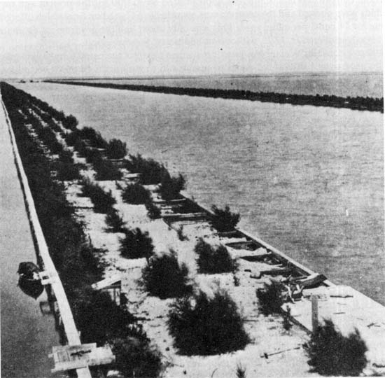 Chart showing the old channel north and west of the "new" St Clair Flats canal: 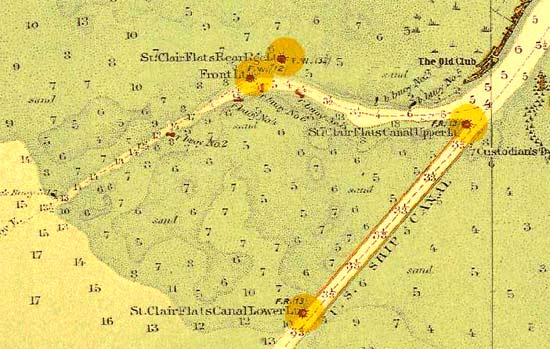 Due to the increase in traffic, a second channel was dredged in 1906 on the west side of the western dike to create separate upbound and downbound channels: 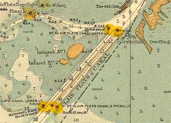 The old western dike which now was the center dike, became a hazard and was removed in the mid-1930s to create one wider, bi-directional channel. | ||
Fareastsider Member Username: Fareastsider Post Number: 316 Registered: 08-2006 |
How far into the lake did the dykes extend? | ||
Mikem Member Username: Mikem Post Number: 3234 Registered: 10-2003 |
I think the dikes were 1½ miles long while the channel extended another mile beyond the end of them. This of course was before the channel was deepened and had to be dredged through the entire length of the lake. | ||
Tigers2005 Member Username: Tigers2005 Post Number: 123 Registered: 02-2005 |
It is interesting to see on the chart above that the islands shown in the area of gull are actually farther to the south than the present location of gull. I believe the location is closer to where the 6 is to the northeast of Island No. 1. | ||
Harsensis Member Username: Harsensis Post Number: 223 Registered: 07-2005 |
Mikem, On the first map picture you posted, is that a lighthouse directly across the channel fro the old club? That is about the location of what looks like an old cement structure or ruins. It has been a while since I looked at it, usually I just zip right by it. | ||
Bibs Member Username: Bibs Post Number: 685 Registered: 10-2003 |
Several times while fishing in the old South Channel near the Old Club on Harsens Island, a older freighter would take the South Channel and blow his horn as he passed the Old Club. Pretty brave captain! I wish I could remember the name of the freighter. Tiger2005 - About 20 years ago, we used to buy minnows from a family out on the flats. They would always be out netting minnow near the Middle Channel and we would just pull up and buy a couple dozen. Do you know if the Minnow Lady still exist? | ||
Fareastsider Member Username: Fareastsider Post Number: 319 Registered: 08-2006 |
Looking at the USGS topo maps of the flats you can see where those dykes extended compared to the present geography. It is interesting to note that St. Clair Co. runs so far south almost to what would be 13 Mile Rd. http://www.dnr.state.mi.us/spa tialdatalibrary/pdf_maps/topom aps/SAINT_CLAIR_FLATS.pdf (Message edited by fareastsider on April 04, 2007) | ||
Harsensis Member Username: Harsensis Post Number: 224 Registered: 07-2005 |
I'm not sure about the minnow lady, but the flower lady is up there sending flowers to the ships. Some of the old captains also take the narrower and deeper Canadian cut past Stag Island too. | ||
Tigers2005 Member Username: Tigers2005 Post Number: 124 Registered: 02-2005 |
Some ships go behind Fawn Island on the Canadian side (across from Marine City). There is a gravel yard behind Fawn where they drop some material. Is there any place that they stop on the Canadian side of Stag? | ||
Tigers2005 Member Username: Tigers2005 Post Number: 125 Registered: 02-2005 |
Bibs, I don't know about the minnow lady. Where were they set up at in the Middle Channel? My Grandfather used to sell bait and tackle from his house in Marine City, though. | ||
Harsensis Member Username: Harsensis Post Number: 229 Registered: 07-2005 |
I can't think of anywhere they unload on the Canadian side of Stag Island. In the old days the ships use to go upbound on one side of the island and down the American side. Now most go up and down strictly on the American side. | ||
Sailor_rick Member Username: Sailor_rick Post Number: 172 Registered: 02-2004 |
Ah, good to hear the "Flower Lady" is still out there thinking about us curs who sail(ed). Her springtime flowers would always brighten up our usually dreary mess rooms. Tiger, Were in M.C.? On Belle River Ave? Do you still have family there? | ||
Bibs Member Username: Bibs Post Number: 686 Registered: 10-2003 |
Talked with my dad this weekend. The freighter we saw going down the Old South Channel was the Henry Ford II on her last voyage to the scrap yard. As for the minnow lady, we always found her in the Sni near Decker's Landing. | ||
Fawnisland Member Username: Fawnisland Post Number: 1 Registered: 04-2007 |
Tigers2005~Here is a picture taken from Fawn Island of a freighter at the gravel pile on the Canadian side. The freighters have to pull up to the gravel pile unload and then have to back out the same way they came in because they can not proceed north behind the island due to shallower water and the the city water pipe lines leading to the Island. http://img.inkfrog.com/pix/big boxer/FAWNISLAND.jpg | ||
Flybydon Member Username: Flybydon Post Number: 108 Registered: 01-2005 |
Gravel dock east of Fawn Island, St. Clair River. 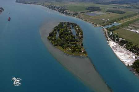 |