 
Miketoronto
Member
Username: Miketoronto
Post Number: 463
Registered: 07-2004
| | Posted on Tuesday, January 23, 2007 - 11:01 pm: |    |
I agree that the bus routes should run on the same street and then split off like was mentioned with Larned Street, Van Dyke, Jefferson.
Thats how we run the routes here in Toronto. For example my route has two routes that run a common service along the street by my house. But a couple blocks after my house they split. One route takes you up one street, the other takes you down to the university. So west of the split you got a bus like every 5-7min, but after the split each route only runs every 10-15min. |
Miketoronto
Member
Username: Miketoronto
Post Number: 464
Registered: 07-2004
| | Posted on Wednesday, January 24, 2007 - 12:01 am: | |
Here is an example how routes could be combined with branches to provide frequent service along parts of a route.
Lets take Jefferson Ave for example. Instead of all the different bus routes, we could combine many of them. Heres my idea.
THE NEW JEFFERSON EAST BUS SERVICE.
The new Jefferson Ave East bus service will feature the following service.
25 JEFFERSON: Downtown Detroit to Eastland Mall, via Jefferson Ave, Atler Road, Outer Drive East, Hayes St, Kelly Road, and 8 Mile Road.
25A JEFFERSON VIA CONNER: Downtown Detroit to Detroit City Airport, via Jefferson and Conner Street.
25B JEFFERSON VIA CADILLAC: Downtown Detroit to Harper/Gratiot, via Jefferson and Cadillac.
SERVICE on each branch will run every 30min, with frequent service west of Conner Street every 15min or less. |
Professorscott
Member
Username: Professorscott
Post Number: 98
Registered: 12-2006
| | Posted on Wednesday, January 24, 2007 - 12:09 am: | |
Mike,
Actually lots of cities run routes that way, and that's how they usually indicate them - the route number followed by a letter. Out in the 'burbs some of the SMART buses have that service but they don't indicate it that way, so for example most runs of the 560 bus go to the Meijer store at 23 and Gratiot, but some turn right on Gratiot into downtown New Baltimore, and up till a year or so ago some other runs turned right toward the Selfridge Air National Guard Base. Yet they are all just numbered 560; I'd rather see 560A, 560B and so on as you mentioned.
I'm still open as to whether routes should converge in this way very much or not; certainly if we ever get rapid transit bus route should converge to RT stations. But if they are going to operate that way, the method you suggest of numbering the routes makes perfect sense.
Shoot, I'd be happy if I could find one phone number where somebody could tell me how to manage a trip that uses both systems. If I have to go from, say, Mount Clemens to the University of Detroit Mercy, good luck figuring that out. Some of you rider-experts might be able to get it done, but Professor Scott Q. Public can't get a handle on it. |
Miketoronto
Member
Username: Miketoronto
Post Number: 465
Registered: 07-2004
| | Posted on Wednesday, January 24, 2007 - 12:25 am: | |
Toronto Transit uses the branch system, so I am use to it. My route is broken up like that, in the following way.
95: YORK MILLS TO KINGSTON ROAD
95A: YORK MILLS TO VICTORIA PARK
95B: YORK MILLS TO U OF T SCARBOROUGH
95E: YORK MILLS EXPRESS TO U OF T SCARBOROUGH
95E buses skip all stops served by the 95A branch west of Fenside Drive except Leslie Street and Don Mills Road.
(Message edited by miketoronto on January 24, 2007) |
Professorscott
Member
Username: Professorscott
Post Number: 99
Registered: 12-2006
| | Posted on Wednesday, January 24, 2007 - 12:45 am: | |
The only thing odd about the TTC that I don't like is they let buses and streetcars trip-jump. That is, at least it seems to be this way, if a bus or streetcar finishes a run early they start the next run right away. So I'll wait a half-hour for a streetcar on a line that is supposed to run with 10 minute headways, then all of a sudden three streetcars in a row show up.
In Detroit they don't allow that; a bus can't start a trip before the scheduled time. I think the SMART system also works that way. On the PeopleMover, of course, the whole thing is computer controlled, and the computer keeps the trains evenly spaced.
Is there something that is supposed to be gained by how TTC does it, or is the assumption that since trips are so frequent it shouldn't matter if they do this? Or was I hallucinating? |
Warrenite84
Member
Username: Warrenite84
Post Number: 13
Registered: 01-2007
| | Posted on Wednesday, January 24, 2007 - 1:18 am: | |
Livernoisyard, in the single mom example mentioned earlier, I understand your comment that she should move closer to the job. It does sound logical. The question here is, wouldn't that cause an expansion of the disinvestment and blight that we are trying to close? Correct me if I'm wrong, but I thought our discussion is an attempt to fill in the donut hole with revitalized homes and businesses. If she is, (and many in her situation), able to keep a job in the burbs and spend her paychecks near her home, the businesses around her prosper and opportunities begin to open up. The trick is to get this economic engine started to grow prosperity to the center and an efficient, clean, safe, well thought out transit system can be the spark. |
Professorscott
Member
Username: Professorscott
Post Number: 100
Registered: 12-2006
| | Posted on Wednesday, January 24, 2007 - 1:31 am: | |
There's also the fantasy that someone in that position has the option to move. Any of y'all ever been poor? Moving is not always an option. Lots of apartments, they want you to come up with two months rent and a security deposit in order to move into a place.
It takes money to cause expansions of disinvestment and blight, and not everybody can afford to do it. I was homeless once, because of these things, and I assure you it is no effin' fun. |
Warrenite84
Member
Username: Warrenite84
Post Number: 14
Registered: 01-2007
| | Posted on Wednesday, January 24, 2007 - 2:03 am: | |
Professorscott, in your post 95 I think you missed what I was trying to say. The "express" I was referring to was having two light rail trains, one labeled "express" and one "local". Not a light rail line on freight tracks. The express/local system could be used to great advantage on other spokes or heavily traveled routes.
I do agree on the low hanging fruit though. The Detroit-AnnArbor commuter service should come first followed by Woodward at least to 8 Mile. In my opinion, the next phase should be extending the 8 Mile line both east and west from Woodward and Michigan Ave. line to Dearborn or Telegraph. Next a start on the Gratiot and Telegraph lines along with Jefferson. What's your thoughts on connecting the inner triangles of the spokes to Telegraph and 8 Mile before extending the spokes to Farmington, Pontiac, and Mt.Clemens? |
Detroitplanner
Member
Username: Detroitplanner
Post Number: 846
Registered: 04-2006
| | Posted on Wednesday, January 24, 2007 - 8:50 am: | |
Warrenite wants the Van Dyke line done next!
I'd think that a Big Beaver/Maple Rd Corridor; with a Greenfield Corridor would make the most sense to do as the first crosstown routes. Lots of jobs along BB and lots of Apartments and shopping Centers along Greenfield. |
Miketoronto
Member
Username: Miketoronto
Post Number: 466
Registered: 07-2004
| | Posted on Wednesday, January 24, 2007 - 10:20 am: | |
Professorscott regarding your TTC question, that is called bunching. The TTC does not send the bus or streetcar out ahead of time. Infact it is all controlled by a central control computer system.
What happens though is if you have a bus or streetcar route running with service every 2min, the smallest delay like a stoplight going red or a passenger taking a second longer to de-board, causes the streetcar/bus to get behind. Then has an effect on all the other streetcars/buses, and before you know it there is a huge gap of service, and then three or four streetcars/buses show up at once, because they all fall behind due to the streetcar/bus ahead of them.
It is a big problem the bunching issue, and alot of it also has to do with car traffic. |
Professorscott
Member
Username: Professorscott
Post Number: 102
Registered: 12-2006
| | Posted on Wednesday, January 24, 2007 - 10:42 am: | |
Mike,
Good to know - that won't happen here - we haven't had a line with 2-minute headways in decades.
Detroitplanner,
The City of Troy also likes your idea and spent a lot of money last year on a study of it. I think you can find the study somewhere deep in the bowels of the City's web site. They want to redevelop the Big Beaver corridor in a more pedestrian-friendly and human-scale way, and they explicitly include transit improvements and a link to a Woodward train as a part of that.
Warrenite,
I'd take a Woodward line at least out to Royal Oak for Light Rail, and all the way to Pontiac for commuter rail - why not - the tracks and stations already exist. For East-West near the Wayne/Oakland border I'd prefer 10/11 Mile to 8 Mile. 8 Mile doesn't have much walkability anywhere along its length nor any concentration of businesses in a human-scale area. (No need to jump in with jokes about topless bars here, I already know.)
Some of my fellow wizards and I got together and tried to come up with a corridor plan for a minimum number of miles of rapid transit corridor that would come within 3 miles of as many people as possible and serve as many transit-supportively dense locations as possible. What we ended up with was that the corridors should be Mt. Clemens to Metro Airport via (approximately) Gratiot and Michigan, Pontiac to Metro Airport via Woodward, Fort and coming up to the Airport from the south, and Roseville to Metro Airport via Royal Oak and Farmington (a beltway line).
This system would be about 125 miles in length, comprise only three lines, come within 3 miles of 65% of the tri-county population, and come within 3 miles of 85% of the transit-supportively dense areas (from census tract data). My numbers here might be a little off; I don't have the document in front of me.
If you draw that on a map, you see it does form the triangles Warrenite mentions.
Professor Scott |
Upinottawa
Member
Username: Upinottawa
Post Number: 738
Registered: 09-2005
| | Posted on Wednesday, January 24, 2007 - 11:18 am: | |
Just for fun: could someone draw that? |
Professorscott
Member
Username: Professorscott
Post Number: 103
Registered: 12-2006
| | Posted on Wednesday, January 24, 2007 - 12:26 pm: | |
I can and have, but not in a reasonable form to post on line. Can someone try it and make a .jpg or .pdf of it? Let me know (in the blog) if you need a little more detail to do it. It doesn't have to be exact, since it isn't exact. |
Warrenite84
Member
Username: Warrenite84
Post Number: 16
Registered: 01-2007
| | Posted on Thursday, January 25, 2007 - 12:37 am: | |
A Van Dyke line... why didn't I think of that?HaHa. A 12 Mile line would suit Warren better by connecting MCCC and the GM Tech Center and Universal Mall. Maybe a BRT line Utica to Gratiot Ave.
Professorscott, that sounds like a good idea to me. I kind of thought that the lines could grow from a primary north/south line and an east/west line. Not fully complete a line before going to the next. I still have to think that idea thru though. The busses could still funnel to the growing endpoints, there would just be more of them earlier. |
Apbest
Member
Username: Apbest
Post Number: 406
Registered: 03-2006
| | Posted on Thursday, January 25, 2007 - 12:52 am: | |
this almost needs to be split |
Professorscott
Member
Username: Professorscott
Post Number: 108
Registered: 12-2006
| | Posted on Thursday, January 25, 2007 - 1:45 am: | |
What almost needs to be split? |
Warrenite84
Member
Username: Warrenite84
Post Number: 17
Registered: 01-2007
| | Posted on Thursday, January 25, 2007 - 2:18 am: | |
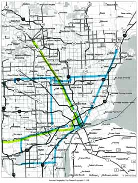
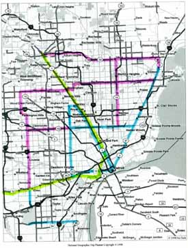
Professorscott, Here is a couple of maps I put together.
The first one I think is what your suggestions were. Blue is LRT and green is Commuter Rail.
The second photo is a rough sketch of what I think phase one should look like. Pink being temporary BRT lines until they, Grand River, Fort St., and the 12/11 Mile Rd lines get built. The BRT lines and regular busses can then feed the LRT and Commuter Lines.
|
Professorscott
Member
Username: Professorscott
Post Number: 109
Registered: 12-2006
| | Posted on Thursday, January 25, 2007 - 2:30 am: | |
Warrenite,
Excellent work. I think we can also do commuter rail in the Detroit to Mt. Clemens corridor with a couple trips to Port Huron each day to meet the Amtrak train.
Professor Scott |
Detroitplanner
Member
Username: Detroitplanner
Post Number: 851
Registered: 04-2006
| | Posted on Thursday, January 25, 2007 - 8:02 am: | |
Looks a lot like SEMCOG's Plan!
http://www.semcog.org/Products /pdfs/transitplan10-01.pdf
see page 54! |
Bob
Member
Username: Bob
Post Number: 1310
Registered: 11-2003
| | Posted on Thursday, January 25, 2007 - 9:48 am: | |
Yes the Van Dyke line is a must. The current SMART Bus Route #510 is very well-used route. You could almost do commuter rail up there with the rail line that goes between Van Dyke and Mound Roads up past M-59. |
Professorscott
Member
Username: Professorscott
Post Number: 110
Registered: 12-2006
| | Posted on Thursday, January 25, 2007 - 11:12 am: | |
Detroitplanner,
The corridor selection in the SpeedLink document didn't make sense to me - they weren't paying attention to what exists along the corridors. So for example, their northern east-west corridors are 8 Mile, 14 Mile and M-59; mine is 11/12 Mile.
Some of the corridors are the same, because some of them are obvious (Woodward, Gratiot).
The essential differences are that they picked twelve corridors and I think you can get an awful lot done with three, and they were basing their selection on existing bus routes primarily and I don't think that is the best way to do it.
Since Rapid Transit is somewhat expensive to implement, I felt the best solution for a region like this where we're starting from scratch is to implement a few lines on high-quality corridors where you have a mix of good activity in some places and redevelopment opportunity in others.
Professor Scott |
Detroitplanner
Member
Username: Detroitplanner
Post Number: 853
Registered: 04-2006
| | Posted on Thursday, January 25, 2007 - 12:23 pm: | |
When SEMCOG put the Transit Plan together there were a series of about a dozen or so public meetings. I participated in several of them. SEMCOG looked at transit supportive areas - areas where people lived and worked and they also led discussions for advice from the users on route locations from the participants. This ensured a good cross-section of people were heard in the planning process.
I'd like to try to see if the lines could be extended or grouped; for example; a line down Michigan could continue up Gratiot to Mt Clements eliminating the need to transfer for those trips. I also don't understand why there is no line to extend and replace the replace the Warren Avenue Crosstown.
What you have is reflective of the needs of what transit riders told SEMCOG and supported by data from the Census Bureau.
What is remarkable about these transit threads is that a lot of the same processes have occurred as what took place in the meetings. |
Warrenite84
Member
Username: Warrenite84
Post Number: 18
Registered: 01-2007
| | Posted on Thursday, January 25, 2007 - 2:19 pm: | |
Detroitplanner, how would you tie-in the People Mover to a Gratiot/Michigan line?
I'd like to see the People Mover stations double tracked so trains could go both directions and have Michigan and Gratiot terminate at a PM station. This would prevent the PM from being bypassed and under utilized. |
Detroitplanner
Member
Username: Detroitplanner
Post Number: 855
Registered: 04-2006
| | Posted on Thursday, January 25, 2007 - 2:31 pm: | |
Put in a bus stop at Cass and Monroe and hand em a transfer to the Michigan or Cadillac Center stops?
As an undergrad I saw a book in the Purdy Kressgee Library that showed an underground platform at the David Whitney Building as the end of the line for the Woodward Route. There was a series of elavators and escalators that would be built, essentially taking out the Whitney Pharmacy.
Double-tracking the people mover would be incredibly expensive; I don't even know if the right of way exists to do this. To be honest, the PM works much better now than it did in the past, with trains every few minutes. I don't think the benefits of adding the other direction could ever be justified over the cost. |
Warrenite84
Member
Username: Warrenite84
Post Number: 20
Registered: 01-2007
| | Posted on Thursday, January 25, 2007 - 2:51 pm: | |
Fair enough.
What do you think about using the Rosa Parks Transit Center for starting points for Fort St., Michigan, and Grand River LRT lines? |
Detroitplanner
Member
Username: Detroitplanner
Post Number: 858
Registered: 04-2006
| | Posted on Thursday, January 25, 2007 - 4:26 pm: | |
To be honest, I don't like the location.
It works well for the lines you stated as well as the Tireman and Dexter bus lines, but it will be a challenge for east side buses to navigate the streets to link here. It will add to the travel times for the east side lines.
It will however be a vast improvement over the Capitol Park area where the buses often crowd both the streets and passengers. Safer too, as a defined area is always easier to patrol than what is found a Capitol Park. |
Professorscott
Member
Username: Professorscott
Post Number: 113
Registered: 12-2006
| | Posted on Thursday, January 25, 2007 - 6:57 pm: | |
I have got a small graphic showing what I originally sketched as the three corridors I'm talking about. (It is not meant to imply a specific choice of mode or anything else specific, just to indicate the primary three corridors based on my study.)
It is a little too big to post here; it is 83 Kb and the limit on this blog is 50 Kb. Does anyone know of a place I could post it where everyone here could go look at it?
Thanks,
Professor Scott |
Warrenite84
Member
Username: Warrenite84
Post Number: 21
Registered: 01-2007
| | Posted on Friday, January 26, 2007 - 12:58 am: | |
Try flickr.com |
Professorscott
Member
Username: Professorscott
Post Number: 121
Registered: 12-2006
| | Posted on Friday, January 26, 2007 - 2:08 am: | |
Thanks Warrenite. See if this works (you can't click it unfortunately, you have to cut and paste it, including the part after "@"):
www.flickr.com/photos/18934145@N00/369645089/
If that link works for all of y'all, that's my sketch. |
Professorscott
Member
Username: Professorscott
Post Number: 127
Registered: 12-2006
| | Posted on Friday, January 26, 2007 - 6:21 pm: | |
Grand Rapids is moving forward. Read this article by Andy Guy of the Michigan Land Use Institute. Interesting and nice to see some progressive thinkers on the west side of the state who understand Michigan doesn't have all the answers and maybe it's OK to get idea from other places.
Rather than post an entire article here, how about the link:
http://www.mlui.org/transporta tion/fullarticle.asp?fileid=17 128 |
Detroitplanner
Member
Username: Detroitplanner
Post Number: 863
Registered: 04-2006
| | Posted on Friday, January 26, 2007 - 6:59 pm: | |
2.4 mile streetcar to circulate folks around the central city? Sounds like the people mover! |
Professorscott
Member
Username: Professorscott
Post Number: 128
Registered: 12-2006
| | Posted on Saturday, January 27, 2007 - 12:06 am: | |
Yes, but unlike the People Mover:
1. This plan will have vehicles at street level, making the service a part of the urban environment rather than operating apart from it, but more importantly,
2. The light rail service will be fully integrated with the bus service so people can use the light rail as part of a longer trip through the region.
The management of the People Mover can't do #1; they certainly could do #2 but have chosen not to, which is astonishing. |
Schulzte1
Member
Username: Schulzte1
Post Number: 3
Registered: 01-2007
| | Posted on Sunday, January 28, 2007 - 11:16 pm: | |
Any commuter rail MUST include Detroit Metro Airport. It would be the busiest and most important stop in such a system. In St. Louis, their rail system began with the Airport/Downtown link and expanded from there. There MIGHT even be a little money for a section like that in D.C. That's how the St. Louis metrorail got the initial funding to start the system.
FYI, building a light rail from scratch costs about $30 million per mile. A new line from Pontiac to Downtown to Ann Arbor would run about a cool $2 billion. That's a hell of a price tag, but nothing compared to Boston's big dig ($8 billion). Does Levin have 1/4 the pull of a Kennedy? |
Professorscott
Member
Username: Professorscott
Post Number: 129
Registered: 12-2006
| | Posted on Monday, January 29, 2007 - 12:23 am: | |
Nobody is any longer considering light rail all the way to Ann Arbor, because of cost and speed. Commuter rail is really the only viable public transportation mode to cover that kind of distance.
As I've said before, if we are going to consider almost $1 billion to upgrade a convention center that is used only sporadically throughout the year, it is not unreasonable to consider similar size investments to fix a basic urban-service gap. Every major urban area on this continent has regional rapid transit, except us. |
Funkysoulchicken
Member
Username: Funkysoulchicken
Post Number: 2
Registered: 08-2006
| | Posted on Sunday, February 11, 2007 - 3:35 pm: | |
I did my graduate transportation planning project on Detroit rail. The thing is a lot of the rail infrastructure exists, it's a matter of repairing...
Anyone seen the U of M airport to AA rail line study? They call it the Aerotropolis...
(Message edited by funkysoulchicken on February 11, 2007) |
Trainman
Member
Username: Trainman
Post Number: 336
Registered: 04-2006
| | Posted on Monday, February 12, 2007 - 5:45 pm: | |
Funkysoulchicken,
Please comment on my transit plan which was made in 1995 and copied by SEMCOG. I made my plan work in June 2003 by working with SMART officials but lost my bus service in the Livonia opt. out.
http://savethefueltax.tripod.c om/theplan.html
Please support my plan to restore the Livonia SMART buses and mass transit's fair share of the state fuel tax. I work in the passenger and freight transportation field. It is my job to keep the trains on time.
Please challenge my plan since you did your graduate work in transportation planning, if you want because my plan worked.
I know that I can make mass transit work because I'm experienced and know a lot. So, maybe you just want to challenge me on this forum and not in public at this time. |
Detroit_stylin
Member
Username: Detroit_stylin
Post Number: 3806
Registered: 10-2003
| | Posted on Monday, February 12, 2007 - 7:52 pm: | |
I would like to make a proposal to the forum...
How about we officially change Trainman's name to "Busman"?
It would go more so with his favorite mode of transit... |
Scs100
Member
Username: Scs100
Post Number: 439
Registered: 12-2006
| | Posted on Monday, February 12, 2007 - 8:13 pm: | |
LOL stylin |
Leland_palmer
Member
Username: Leland_palmer
Post Number: 229
Registered: 08-2004
| | Posted on Thursday, February 22, 2007 - 12:03 pm: | |
Not directly related but...
Funding sought for rail service
Valerie Olander / The Detroit News
NORTHFIELD TOWNSHIP -- A coalition pushing for a temporary commuter rail service to bypass construction along U.S. 23 plans to apply for a federal grant that could fund up to 80 percent of the $2.4 million cost.
The plan is for rail service between Ann Arbor and an area north of Whitmore Lake.
http://detroitnews.com/apps/pb cs.dll/article?AID=/20070221/M ETRO/702210376/1003 |
Trainman
Member
Username: Trainman
Post Number: 342
Registered: 04-2006
| | Posted on Monday, February 26, 2007 - 7:13 pm: | |
I'm trainman because I work for a railroad. I used to ride SMART because I wanted to help them fix the wheelchair lifts for those who can't drive. I can't use mass transit unless there is a bus between my house and work every half hour.
It seems to make sense to have SMART buses on the downtown and airport bus routes every half hour but without more riders and dedicated mass transit taxes it is not likely to happen.
Our state leaders could have stopped the Livonia opt. out but did nothing. This cost our state jobs and if we don't get mass transit leadership in Lansing then more jobs will be lost. This is a fact that is backed up with many sources. I'm sure not a single DY er can or will challenge this fact, unless they want to look and be stupid instead of being SMART. |
Rbdetsport
Member
Username: Rbdetsport
Post Number: 238
Registered: 11-2005
| | Posted on Monday, February 26, 2007 - 11:02 pm: | |
Are you in a wheelchair? |
Professorscott
Member
Username: Professorscott
Post Number: 219
Registered: 12-2006
| | Posted on Monday, February 26, 2007 - 11:51 pm: | |
Trainman,
Curious how our state leaders could have prevented the Livonia opt out. I was pleased that Macomb County's commission had the presence of mind to set up the transit millage as an all-or-nothing affair, so every single community in Macomb County has some kind of transit.
Wayne and Oakland Counties would have benefited from the same wise choice, but chose the other path, and you see the result. But these were decisions of the County Commissions, not the Government of Michigan.
Now, if Engler hadn't vetoed the original judge-proof DARTA legislation, we might be in a different place today, but that's just one person screwing the State. Still though, I have great hopes that Mr. Hertel will be able to accomplish the nearly-impossible.
If he's successful at this I might recommend we next send him to the Middle East to sort that muddle out. |
Trainman
Member
Username: Trainman
Post Number: 345
Registered: 04-2006
| | Posted on Tuesday, February 27, 2007 - 5:19 pm: | |
The state had lots of power to stop the opt out. Our state leaders that represented Livonia came to our city hall and bashed in the city of Detroit and told the residents that our state will never invest in mass transit. The DARTA supporters claimed that Livonia can easily pay for Detroit with as little as just 90 dollars a year and they even promised on-time DDOT buses, if only we could all just pay a little more.
The DARTA and the Transportation Riders United both succeeded in hyping mass transit as the cure all for all of problems, just like the snake oil salesmen of the 1800's.
Yes, there was lots that could have been done, but nothing was done except lots and lots of talk.
What our area needs are people who take action and get the job done.
But instead we got DARTA and lots of bullshit.
And this among many other reasons is why Livonia lost SMART.
(Message edited by Trainman on February 27, 2007) |
Professorscott
Member
Username: Professorscott
Post Number: 227
Registered: 12-2006
| | Posted on Wednesday, February 28, 2007 - 12:32 am: | |
Which state leaders are these?
And how can you blame DARTA, an organization that for all practical purposes does not exist?
How did promoting mass transit lead to a City's decision to eliminate mass transit?
Your post is very confusing to me. |
Lmichigan
Member
Username: Lmichigan
Post Number: 5164
Registered: 10-2003
| | Posted on Wednesday, February 28, 2007 - 1:41 am: | |
This is not your first time dealing with Trainman, is it? Just a heads up, but rule #1 is that with Trainman, it doesn't have to make sense. |
Professorscott
Member
Username: Professorscott
Post Number: 229
Registered: 12-2006
| | Posted on Wednesday, February 28, 2007 - 2:00 am: | |
Lmich,
Thanks for the heads up. I give everyone the benefit of the doubt at first, but they can earn their way out of it.
Everyone,
What is your vision for transit in the D and surrounding burbs? Keep ad hominem attacks to a dull roar; I am just a lowly Professor. |