Dtown1 Member Username: Dtown1 Post Number: 66 Registered: 08-2006 Posted From: 68.253.101.134 |
I have a question about Connor Creek. Where was the actual Connor Creek neighborhood located (between what streets). Also, can you sort of describe how the neighborhood used to look like and how it looks now. I heard it usd to be on the spot where the Jefferson North Plant is. Is this true? | ||
Bibs Member Username: Bibs Post Number: 559 Registered: 10-2003 Posted From: 152.163.100.8 |
This subject has been discuss in great detail before on this form. The discussion included postings of historical maps. I tried to search the archives but I couldn't find the thread. See search form on the left side of the home page. | ||
Mikem Member Username: Mikem Post Number: 2802 Registered: 10-2003 Posted From: 68.43.15.105 |
https://www.atdetroit.net/forum/messages/6790/25121.html | ||
Lmichigan Member Username: Lmichigan Post Number: 4315 Registered: 10-2003 Posted From: 67.177.81.18 |
I really wish Detroit would have saved some its phyiscal geography as it grew instead of literally flattening most all of the few hills and streams the landscape had. Since Connor Creek has been discussed, could anyone post some maps of where the old Savoyard Creek used to run through? A search didn't turn up anything. (Message edited by lmichigan on September 01, 2006) | ||
Ordinary Member Username: Ordinary Post Number: 15 Registered: 06-2006 Posted From: 68.79.89.113 |
Lmichigan, Someone told me that the only place that really shows the way Detroit looked before it was flattened is Elmwood Cemetery. | ||
Lmichigan Member Username: Lmichigan Post Number: 4316 Registered: 10-2003 Posted From: 67.177.81.18 |
I've also heard Palmer Park, but that's really far north, and not part of the original city. I've also heard that Highland Park actually used to sit on considerably elevated land. Is there any truth to that? | ||
Hornwrecker Member Username: Hornwrecker Post Number: 1546 Registered: 04-2005 Posted From: 216.203.223.68 |
Ft Shelby, and the aforementioned Savoyard Creek. 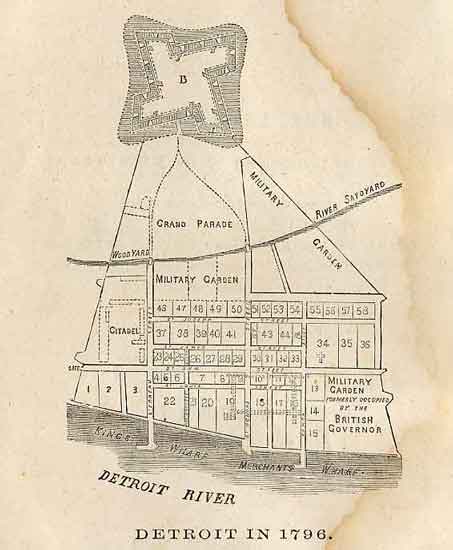 | ||
Mikem Member Username: Mikem Post Number: 2805 Registered: 10-2003 Posted From: 68.43.15.105 |
From Burton's City of Detroit, 1922:
In a later chapter about the history of Griswold Street:
This is a crude map of Detroit in 1796, drawn for an historical magazine in 1879, showing the course of the Savoyard though the town: 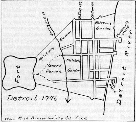 | ||
Lowell Board Administrator Username: Lowell Post Number: 2910 Registered: 10-2003 Posted From: 66.167.211.42 |
Great info as usual. BTW, I have moved the Conner's Creek thread to the HOF. Click here to go there. Perhaps we can combine it with this under something like The Lost Waterways of Detroit, Primitive Detroit, Pre sprawl Detroit or some such name. | ||
Mikem Member Username: Mikem Post Number: 2807 Registered: 10-2003 Posted From: 68.43.15.105 |
Sounds good Lowell. I'll get Hornwrecker on that, pronto! Another map of Connor's Creek, from ~1921:   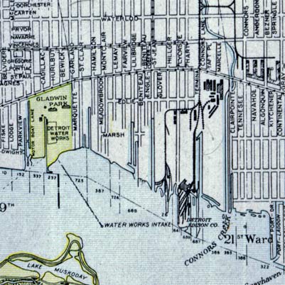 | ||
Lowell Board Administrator Username: Lowell Post Number: 2911 Registered: 10-2003 Posted From: 66.167.211.42 |
How does this look for the Savoyard from the description above with Mrs. Deveaux's lot the red square?  Side thought: Wouldn't that, in fact, put the Savoyard Club in the Buhl Bldg. literally on top of the Savoyard? | ||
Lmichigan Member Username: Lmichigan Post Number: 4317 Registered: 10-2003 Posted From: 67.177.81.18 |
Lowell, yes to your last question. The Buhl Building has a website, and it says the Buhl is built directly atop the site of the old creek, and that it runs underneath the ground as a sewer. That's why I was interested in knowing the full course of the creek. | ||
Hornwrecker Member Username: Hornwrecker Post Number: 1548 Registered: 04-2005 Posted From: 216.203.223.89 |
I've seen a map of the Savoyard, or have it on my computer misfiled somewhere, but that is pretty damn close to what it was. The main difference would be that the shoreline was more to the north, and there was the bluff along the river. There was a lot of fill done since them. I'll have to go back and search the NOAA archives and get their viewing program again. They've got an extensive archives of period nav maps. | ||
Lmichigan Member Username: Lmichigan Post Number: 4319 Registered: 10-2003 Posted From: 67.177.81.18 |
Yeah, apparently, like a lot of other cities, Detroit has reclaimed a significant amount of downtown waterfront land. | ||
Gistok Member Username: Gistok Post Number: 2746 Registered: 08-2004 Posted From: 4.229.72.53 |
Having been to the Savoyard Club for a buddy's wedding in 1986, I am disappointed that the empty space hasn't been transformed into an entertainement spot. The 26th floor of the Buhl Building has stunning vistas, and great views of the (hard to see) Guardian Buildings fancy top. | ||
Hamtramck_steve Member Username: Hamtramck_steve Post Number: 3228 Registered: 10-2003 Posted From: 69.220.69.129 |
The changes needed to make the Savoyard Club ADA compliant were too costly. The passenger elevator only goes to the 26th floor, whereas the club is on the 27th. The freight elevator goes all the way to the top, but you can't transport passengers in a freight elevator. The women's bathroom is on the 26th, and is not ADA compliant, and neither is the men's bathroom which is on another level. The building owner ran through the numbers to bring it all up to snuff, and it was around $500,000, and that didn't even factor in cleaning up the disgusting kitchen. That was just too much for the building owner to carry, and nobody approached them with an offer to create a restaurant there. The space is no longer unused, though. A new tenant moved in within the last year (not counting City Yoga). | ||
Bvos Member Username: Bvos Post Number: 1931 Registered: 10-2003 Posted From: 70.228.57.79 |
I saw the Connor Creek thread with mentions of Bloody Run/Parent's Run in it. Does anyone know what it would take (ie. costs and physical work) to start the process of daylighting them? I say start at the Detroit River and work back to their source. Cities like Minneapolis have all/most of their original creeks and streams running through them, as well as much of the original topography, and the neighborhoods along these creeks are amongst the most desirable in the city. You literally walk a few hundred feet or so and you go from city living to being immersed in nature to the point that you forget you're in the middle of the city. Unearthing Bloody Run/Parent's Creek is probably amongst the easiest/most logical. It basically runs along Chene St. which is greatly abandoned in many places. | ||
Hamtramck_steve Member Username: Hamtramck_steve Post Number: 3230 Registered: 10-2003 Posted From: 69.220.69.129 |
Since most of Detroit's creeks became part of the sewer system, I would put the costs of cleanup very high. This might limit how attractive they are to live next to, also. Look at Fox Creek and the troubles they have/had with Grosse Pointe poop flooding their yards. | ||
Lmichigan Member Username: Lmichigan Post Number: 4342 Registered: 10-2003 Posted From: 67.177.81.18 |
Most old cities don't even bother burying powerlines, anymore, let alone trying unearthing and restoring creeks for purely aesthetical purposes. It doesn't make a lot of financial sense, and especially for cash-strapped cities. | ||
Fishtoes2000 Member Username: Fishtoes2000 Post Number: 126 Registered: 06-2005 Posted From: 69.14.20.35 |
The City of Pontiac has plans but no money to daylight the Clinton River through downtown. It's mostly covered by surface parking lots. | ||
Livernoisyard Member Username: Livernoisyard Post Number: 1335 Registered: 10-2004 Posted From: 69.242.223.42 |
Holbrook Creek was a bit larger than most at being around 25 feet wide. Is there still sizeable fluid flow from that creek? | ||
Hamtramck_steve Member Username: Hamtramck_steve Post Number: 3231 Registered: 10-2003 Posted From: 69.220.69.129 |
Holbrook is completely buried. | ||
Livernoisyard Member Username: Livernoisyard Post Number: 1344 Registered: 10-2004 Posted From: 69.242.223.42 |
buried meaning filled in? or diverted to the sewers? | ||
Hamtramck_steve Member Username: Hamtramck_steve Post Number: 3234 Registered: 10-2003 Posted From: 69.220.69.129 |
It's a sewer. | ||
Livernoisyard Member Username: Livernoisyard Post Number: 1345 Registered: 10-2004 Posted From: 69.242.223.42 |
My question was about how much flow was from the creek. When it isn't raining, the storm sewer flow there should be mostly all "Holbrook Creek." | ||
Hamtramck_steve Member Username: Hamtramck_steve Post Number: 3235 Registered: 10-2003 Posted From: 69.220.69.129 |
That's assuming the storm sewer and sanitary sewer are separate in that area. It's so old, I highly doubt it. | ||
Livernoisyard Member Username: Livernoisyard Post Number: 1346 Registered: 10-2004 Posted From: 69.242.223.42 |
I remember a creek near my home as a kid in Milwaukee when one of the early shopping centers went in around 1955. There was a small creek that I never really noticed before and after a month or so, it just disappeared (into the sewers). The storm sewer would have emptied into another nearby creek. On another matter, Milwaukee paid over $120 million to revamp a 9-mile long, urban creek--Lincoln Creek, four blocks from where I lived as a kid. We used to go "crabbing" there for crayfish all the time and catch and sell fifty or more of them apiece to fishermen or cook them ourselves. We used several lines of cord or string attached to meat or salt pork by a small dam by 47th Street built by the CCC during the Depression. |