586luvfor313 Member Username: 586luvfor313 Post Number: 1 Registered: 07-2006 Posted From: 209.64.87.68 |
I have finally done it. . After 4 years of reading every day, I decided to post. My families first home after they immigarted here was on 6 and Van Dyke (Dobel) that they purchased in 1973. I was wondering if anyone here might have grown up in same area and have pictures to share? | ||
Hornwrecker Member Username: Hornwrecker Post Number: 1336 Registered: 04-2005 Posted From: 216.203.223.82 |
Here's a map of how that area looked in 1915 when it was the Village of North Detroit. The red push pin is where the railroad station/post office was. 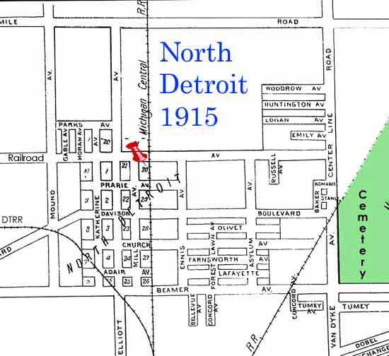 I grew up north of there, near Van Dyke and Outer Dr. OLQH | ||
Chefdave Member Username: Chefdave Post Number: 60 Registered: 04-2004 Posted From: 68.85.144.61 |
My great grandparents lived on belvedere street. I think that it was near there. | ||
Livedog2 Member Username: Livedog2 Post Number: 749 Registered: 03-2006 Posted From: 24.223.133.177 |
Hornwrecker, what's the name of the cemetery in the far Eastern portion of the map you posted just above me? ^ | | | Livedog2 | ||
Kathleen Member Username: Kathleen Post Number: 1451 Registered: 10-2003 Posted From: 140.244.107.151 |
It's Mount Olivet Cemetery. | ||
Livedog2 Member Username: Livedog2 Post Number: 750 Registered: 03-2006 Posted From: 24.223.133.177 |
Thanks, Kathleen. I wasn't sure if it was Mt. Olivet or Forest Lawn because of the orientation of the map. I think it's interesting that what is now Davison St. E. that was at one time called Davison Ave. E. in the Polk Directory was called Davison Boulevard on the map Hornwrecker posted above on this thread. Livedog2 just noticing... | ||
Thursdaynext Member Username: Thursdaynext Post Number: 306 Registered: 04-2006 Posted From: 69.212.208.137 |
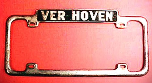
My Grandparents, aunts and uncle lived on Tumey when they came over from Holland after WWII. My Uncle first settled here with his wife and then the rest of the family moved into the house next door to his. My Grandfather, who unforunately died before I was born, worked at Ver Hoven Chevrolet, he could just walk down the street to work every morning as it sat right at 6 & Van Dyke. Niether home stands anymore, just grassy lots. I vaguely remember visiting my uncles home when I was a youngin' in the early 70's. I loved walking around in their little garden then take a break to have a salami sandwich and a shirley temple (extra cherries) for lunch. I believe my uncle worked for Swift as a butcher, needless to say, the family always had plenty of cold cuts and nice cuts of meat for the dinner table. Family's name was Smeekens. Any chance that rings a bell with you 586luvfor313? Since Dobel was so near to Tumey maybe someone in your family knew Jack and Marie Smeekens. Livedog2, I think the cemetery is Mt. Olivet, where my grandparents now peacefully reside. Big catholic cemetery. I try to visit there once a year with my mother. When driving through, she recognizes so many names of the Dutch families that used to live in that area. I'd love to know more about this area myself, so if anyone has more to share please post away.  | ||
Thursdaynext Member Username: Thursdaynext Post Number: 307 Registered: 04-2006 Posted From: 69.212.208.137 |
Ooops, didn't see Kathleen had posted about Mt. Olivet before I submitted my post. Thanks for confirming though, for some reason I was a bit thrown off with the map. | ||
Wash_man Member Username: Wash_man Post Number: 46 Registered: 05-2006 Posted From: 64.118.138.34 |
I've noticed the fence at Mt. Olivet has been torn down and replaced with what looks like temporary fencing. New iron posts have been installed and it looks like the entire fence is being replaced. If the new posts are any indication of what the new fence will look like, it should be beautiful. Is the Metro 25 tire place across the street on the southeast corner what used to be a car dealer? Very interesting, I always wondered what that was. The building is in great condition and the current occupants should be commended on the appearance of their business. | ||
Hornwrecker Member Username: Hornwrecker Post Number: 1338 Registered: 04-2005 Posted From: 216.203.223.111 |
The map is oriented to the north, what's confusing is the lack of streets and different names. Here is an expanded view of the area, as large a I can make it right now. 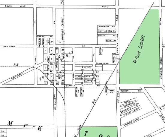 | ||
Kathleen Member Username: Kathleen Post Number: 1452 Registered: 10-2003 Posted From: 140.244.107.151 |
Forest Lawn Cemetery is about 1/2 mile south of McNichols and on the west side of Van Dyke. | ||
Kathleen Member Username: Kathleen Post Number: 1453 Registered: 10-2003 Posted From: 140.244.107.151 |
Thanks, Hornwrecker, for this more detailed map. Interesting to note the close proximity of the two streets--Mt. Olivet Ave. and Forest Lawn--south of McNichols, east of Van Dyke. | ||
Hornwrecker Member Username: Hornwrecker Post Number: 1340 Registered: 04-2005 Posted From: 216.203.223.111 |
I forgot to add that Gunston, street east of "Connor Creek Rd" is labeled Grotto back then. I'll see if I can whip up an old aerial photo and post later. | ||
Ed_golick Member Username: Ed_golick Post Number: 341 Registered: 10-2003 Posted From: 69.246.55.51 |
Ver Hoven, at 6 and Van Dyke, was the official Soap Box Derby Headquarters. That's where you would buy the wheels and axles that all Derby cars were required to use. I never participated or knew anybody who did, but I always watched the races on WWJ-TV. | ||
Livedog2 Member Username: Livedog2 Post Number: 752 Registered: 03-2006 Posted From: 24.223.133.177 |
Hornwrecker, do you happen to have a map from the same era, 1915, as the one you posted earlier on this thread that includes the area bounded by 6 Mile, Ryan, Dequindre and Holbrook? If so can you post it? Thanks. Livedog2 | ||
Maxcarey Member Username: Maxcarey Post Number: 16 Registered: 07-2006 Posted From: 68.43.105.109 |
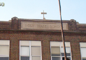
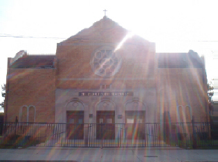
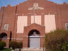
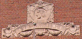
Holy Name church and school was south of 6 mile, it is now Shield of Faith Ministries. I will attach some pictures of the church and school as of May, 2006. | ||
Maxcarey Member Username: Maxcarey Post Number: 17 Registered: 07-2006 Posted From: 68.43.105.109 |
 | ||
Maxcarey Member Username: Maxcarey Post Number: 18 Registered: 07-2006 Posted From: 68.43.105.109 |
 | ||
Maxcarey Member Username: Maxcarey Post Number: 19 Registered: 07-2006 Posted From: 68.43.105.109 |
 | ||
Maxcarey Member Username: Maxcarey Post Number: 20 Registered: 07-2006 Posted From: 68.43.105.109 |
 | ||
Detroitej72 Member Username: Detroitej72 Post Number: 117 Registered: 05-2006 Posted From: 66.184.3.44 |
My grandmother grew up at Van Dyke and Harper, just south of there. She told me of the story how when she was in high school around 1940, there was a story circulating about a ghost that could be seen at the corner of VD and 6 Mile. Sort of Detroit's answer to Reserection Mary in Chicago. Anyone know anything about this? | ||
Hornwrecker Member Username: Hornwrecker Post Number: 1342 Registered: 04-2005 Posted From: 66.2.148.83 |
The aerial view, from 1961 Det Ed surveys, culma/wsu. 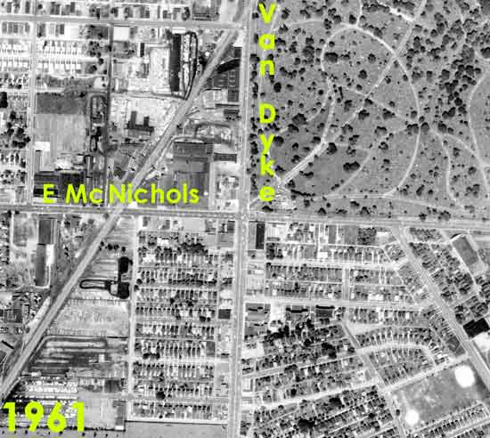 Holy Name, our arch rivals at Queen of Heaven. The second pic is of the original church, later the gym. They had a pipe organ in it, that I got roped in to help move to the main/new church way back. What was your local theater, Nortown or Ramona? Pic of Nortown in the HOF Movie House thread. Livedog, I want to say yes, but I think it would take many hours work to make as presentable as the ones I posted here. There's a lot of cleaning up, and removal that needs to be done. Perhaps for a Hamtramack mega-thread in the distant future. | ||
Livedog2 Member Username: Livedog2 Post Number: 755 Registered: 03-2006 Posted From: 24.223.133.177 |
That's OK, Hornwrecker. It's not that important. Like you said maybe another time for the future Hamtramck mega-thread in the distant future. Livedog2 | ||
Hornwrecker Member Username: Hornwrecker Post Number: 1344 Registered: 04-2005 Posted From: 66.2.148.83 |
 Someone was selling this on ebay, found it in google-cache. | ||
Rjk Member Username: Rjk Post Number: 424 Registered: 11-2003 Posted From: 68.41.145.5 |
Anyone know when Mt. Olivet Cemetery expanded into the newer section on the east side of Outer drive and what was previously located in that area? Thanks. On a side note I have relatives buried in both sections and it's interesting contrasting the length of the lives of the people buried in each section. It's amazing walking through the old section and seeing the number of children (2-3 years old and younger) who died in the last 1800's/early 1900's. | ||
Formerspringgardener Member Username: Formerspringgardener Post Number: 8 Registered: 07-2006 Posted From: 68.85.136.144 |
I worked at the northeast corner of 6 & Van Dyke at Woodall Industries. That was in 71 and 72. They used to make a lot of parts for Chrysler. Remember those Dodges around that time with the vents for rear windows? They made those vents out there. I believe they shut down in the late '70s or early 80's. Rjk - Can't help you with what used to be there. For the last 60 or so it has been cemetery. Hopefully someone has some idea. | ||
Hornwrecker Member Username: Hornwrecker Post Number: 1348 Registered: 04-2005 Posted From: 66.2.148.143 |
Mt. Olivet Cemetery 1949 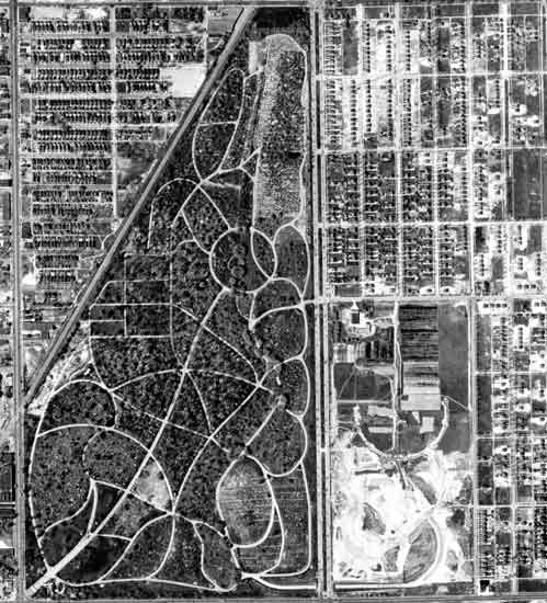 A close-up of the intersection reveals that the underpass is completely built, and grading is being done on the annex, or whatever it is that they call it. Looking at enlargements of the the northern section, it appears that it was a plant nursery, and maybe some greenhouses, probably operated by the cemetery before. 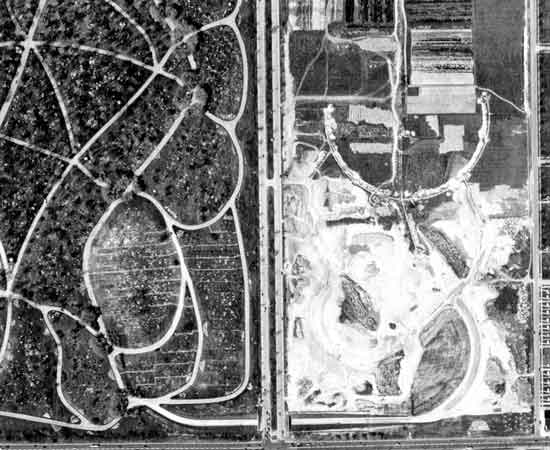 My best guess is that is was started shortly after the war, and was totally done by the late 1950s. That is as early as I can go on the date for aerials. | ||
Rjk Member Username: Rjk Post Number: 427 Registered: 11-2003 Posted From: 68.41.145.5 |
Hornwrecker, nice find on your part. Your guess is probably right. The cemetery probably owned that land for some time or at least bought it when that area started to develope, thinking of expansion. | ||
Livedog2 Member Username: Livedog2 Post Number: 770 Registered: 03-2006 Posted From: 24.223.133.177 |
Great maps, Hornwrecker! Many moons ago I use to courier ground and aerial maps to MACVSOG Hdqtrs. in Saigon from my Force Recon Group working in conjunction with the SF Mike Force up in I Corps. So, anytime I get to pour over a map I’m a happy camper. Thanks for the work you have done on these maps and all the others you have posted. Livedog2 | ||
Brizee Member Username: Brizee Post Number: 2 Registered: 07-2006 Posted From: 66.147.136.50 |
I grew up on Dobel(Lynch Annex FOLYFE!). My father/brother, cousin and her husband, and aunt still live in three houses next door and across the street from each other. No pictures at the moment. | ||
Stinger4me Member Username: Stinger4me Post Number: 27 Registered: 08-2007 |
My grandmother is buried in an older section of Mt. Olivet close to the north end of the cemetery. She died in the flu epidemic of '17. My aunt died just a short time later and is buried near her, the north end of the large part. Both graves are very close to the railroad tracks. It seems the new part was without burials in the mid to late 50's. There were a lot more trees in the place back then. You could see remnants of the bridges where the water flowed at one time. I spoke with a policeman who started in 1927. Outer Drive and Van Dyke was nothing but woods back then. Hope this helps. | ||
Shannonhappy Member Username: Shannonhappy Post Number: 2 Registered: 01-2008 |
Friends of Fletcher Field is a newly formed non-profit working to revitalize the park in that area & the surrounding neighborhood. Check out http://community.detnews.com/b logs/index.php/neighborhood for details of the project. Anyway, as a fundraising effort, we are organizing a reunion for Holy Name of Jesus parish & school, and the surrounding community. Getting hundreds of replies to attend! Money raised goes to the park. If you want more information, email me at hnsreunion@wowway.com. I'll send the details. Hope to hear from everyone soon! |