Hornwrecker Member Username: Hornwrecker Post Number: 1947 Registered: 04-2005 |
Bc_n_dtown, start looking at ties to Henry Ford, since he helped with or funded the developement of the Aviation Sub. The Bentley Lib at UoM lists a map of the Ford Hghwy in its archives, and if there's a for connection, start with The Henry Ford online. 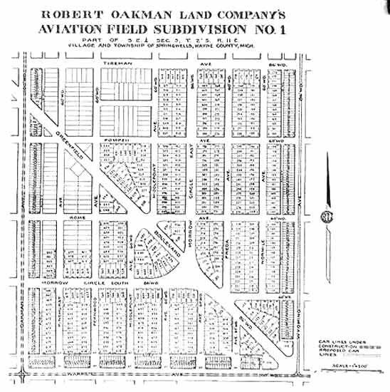 I also found mention of him with the Dodge Bros: John attracted less favorable attention in 1911, when newspaper headlines announced that he and his friend Robert Oakman had insulted and beaten handicapped attorney Thomas J. Mahon in a brawl at Schneider's Bar in Detroit. Both brothers were heavy drinkers, prone to belligerence when under the influence of alcohol, and they had a reputation in the city saloons for aggressive behavior. After the Mahon incident, however, "the escapades of the Dodges, which had been looked on by some with an admiring tolerance," state Pitrone and Elwart, "were suddenly viewed differently." The suit Mahon filed against Dodge and Oakman was eventually dropped, but the damage to John's reputation could not be undone. If a guy gets into bar brawls with his drinking buddy John Dodge, he probably also got him to invest in his real estate schemes. Don't know if the Chrysler Museum has all of the Dodge papers, or where they might be. (Message edited by Hornwrecker on December 15, 2007) | ||
Jjaba Member Username: Jjaba Post Number: 5757 Registered: 11-2003 |
Do we konw where Schneider's is located? Sounds Eastside. Maybe they got photos on the walls of our party guys. jjaba. | ||
Hornwrecker Member Username: Hornwrecker Post Number: 1948 Registered: 04-2005 |
My memory is leaning towards somewhere around Woodward, Cadillac Sq area. I know I read about it in some book, but the indexing in most of them are suspect, if it exists at all. Was this the place with the carved wooden indian in front? Sounds like something the Rock would know about: a bar where lawyers get beaten up. | ||
The_rock Member Username: The_rock Post Number: 2049 Registered: 11-2003 |
jjaba continues to wow us with his knowledge of Detroit, its environs and residents. Interesting that he post a thread about Oakman and that he was a delegate to the 1920 Republican convention in Chicago. So was my Grandfather, also an Oakland County Circuit Judge. I have a huge 4 foot by 3 foot black and white photograph taken of the convention floor and the many delegates. Not only is Grandfather there, but his wife is sitting on the convention floor right next to him!! I don't think they allow that any more. I wonder if she got to cast a vote too? Next time you are on the East side, jjaba, stop by and I will show you the photograph and maybe you can pick out Oakman in the crowd. And believe me, it is a crowd. I have never seen a gathering of so many Republicans at one sitting, but I guess a Convention is the logical place for them to be seen. | ||
Durango Member Username: Durango Post Number: 72 Registered: 10-2006 |
Hornwrecker, I went to elementary school at St. John's Lutheran at 4950 Oakman in the seventies. I had a number of friends who lived on Pinehurst, Esper,and Littlefield. What is the origin of the Aviation Field name for the subdivision? At one time, did Henry Ford use the area for an airfield during the early part of the 20th century? Photo is from 9/5/57 courtesy of the Wayne State Virtual Motor City Library.  | ||
Hornwrecker Member Username: Hornwrecker Post Number: 1949 Registered: 04-2005 |
Not exactly sure of the airfield's history (need Mikem for that), but here is a brief one on the sub's website: {Aviation Sub was Haggerty Field, later renamed Morrow Field after Lt. Karl Morrow's accidental death in an air show over Detroit the day after the WWI armistice. } http://www.aviationsub.org/his tory.html Listed as a WWI, aviation general supply depot and acceptance park, in government records. More here: http://www.detroitrising.com/bartonmcfarlane.htm (Message edited by Hornwrecker on December 15, 2007) | ||
Broken_main Member Username: Broken_main Post Number: 1361 Registered: 06-2005 |
I grew up on the North side of Joy Rd. on Manor. The first house that I bought was in the Aviation sub on Freda(first block off Tireman) I have always loved this neighborhood. DURANGO, my godmother taught at St. Johns. She stayed on Oakman as well. Her name was Mary Mathis. She may have been your teacher. Her neighbor's (the Tonn's) were also affiliated with the church as well. | ||
Msamslex Member Username: Msamslex Post Number: 21 Registered: 06-2007 |
Jjaba, Glad you enjoyed my story. Like I said I love my street and the neighborhood. I find it fascinating that the streetcars ran through here years ago. Just can't imagine how that looked. Visitors and new neighbors just can't get over how quiet it is around here. We do get the boomboxes on wheels coming down Belton and my street (of course summertime especially) but overall it's peaceful. Now one thing that gets annoying sometimes is the planes making that last circle before the beeline to Metro. They fly so low sometimes you can just about see the passengers!! Just kidding!! You can read the airline's name on the plane when they're really flying low. I can spot NWA a mile away!••• Fortunately the noise only lasts for a few and they fly on. Now what was scary to me(this has nothing to do with the neighborhood) I was visiting friends out in Inkster when a plane was coming in and the whole back of the house lit up from the plane's lights. I was terrified!! Those planes also have a bad habit of making too much noise when you're trying to talk outside or hear an important part of the show or movie you're watching. Most annoying. Hornwrecker, I was studying the map of the area you posted and I see the street listed as Greenfield running into Wyoming. Of course we know that it's Littlefield now. How old is the map and when did the name change? Did the Greenfield we know now exist or what was the name then? | ||
Broken_main Member Username: Broken_main Post Number: 1363 Registered: 06-2005 |
Msamslex, What street are you on in Aviation? | ||
Hornwrecker Member Username: Hornwrecker Post Number: 1950 Registered: 04-2005 |
1920(s) for the map, found it for sale online from a search: "robert oakman"+aviation. | ||
Msamslex Member Username: Msamslex Post Number: 22 Registered: 06-2007 |
Broken main On Morrow Circle. | ||
Msamslex Member Username: Msamslex Post Number: 23 Registered: 06-2007 |
Gannon, There's no North Morrow Circle although it runs north and south not unless somebody knows something I don't know. In Dearborn the street signs say Morrow Circle East to Morrow Circle South as you cross Littlefield, then curve around and just as you cross Esper it's Morrow Circle West which changes to Cheyenne on the Detroit side. Apparently the official listing with the post office is E. Morrow Circle because our mail from businesses and such are addressed this way. Have had to direct many folk over the years who "got lost" in Dearborn when they ended up on Morrow Circle W. at Tireman especially right after we moved over here. No one knew anything about the street. When people asked me what street I lived on and I told them, a standard response was "Is that near Ewald Circle?" If you study the map Hornwrecker posted you'll see how it Morrow Circle curves around. | ||
Durango Member Username: Durango Post Number: 73 Registered: 10-2006 |
Broken_main, The older you get the smaller the world gets. I never had Ms. Mathis as a teacher, what grade did she teach? I was there from K-8 which was from 1973 - 1982 before I went to Renaissance. Mrs. Tonn was our Pastor's wife. They had two daughters and son. I do believe the church owned their home and the red brick home on the corner of Westfield and Wisconsin. Ms. Tonn taught the children's choir and was a substitute at the school when I was there. I believe her husband passed away six seven years ago in Detroit. We used to ride our bikes from Franklin Park, on the other side of the Southfield Freeway, to ride up and down Oakman in the summer. It was only about 4 or 5 miles each way riding down Chicago Blvd east. | ||
Swede1934 Member Username: Swede1934 Post Number: 37 Registered: 04-2007 |
Jjaba.. In reading your escapades on the Oakman car line, I seem to remember a streetcar bridge that crossed what was then known as the "Willow Run Expressway" before it became part of I94. The bridge no longer exists, but I wonder if it brought the Oakman car into the Rouge complex. | ||
Gannon Member Username: Gannon Post Number: 11120 Registered: 12-2003 |
Ha, Big Loop. South, East, or West? Whatever happened to North Morrow Circle? Who's this Mackenzie fellow?! 8235 Appoline, approximately 1966 'til just before the nation's bicentennial, but right on through Nixon's embarrassment. Great house, amazing neighborhood. Should've seen it before the Elm's fell to the Dutch. EVERY city employee serving the west side certainly took a nap or two during the lunchtime shade on our street. It was like a foliage cathedral. Cheers! | ||
Gannon Member Username: Gannon Post Number: 11121 Registered: 12-2003 |
Msamslex, Sorry, I corrected this post on the year we moved into Appoline, and it got dumped to the bottom. Funny about that, we used to run our little 20" chopper bikes around the neighborhood, and since I lived north of Tireman I used to run into the name change...and the lack of continuity always bothered me! Got an old family friend living near you (or used to before St. Al's school closed), on the curve of Morrow Circle at Littlefield, great fellow...Henley. Been years. Cheers! (lovin' the number o' newbies on this thread) | ||
Msamslex Member Username: Msamslex Post Number: 24 Registered: 06-2007 |
Gannon, Yes it is strange how some street names are the same from Detroit to Dearborn and others change. Another thing. When the street name signs along Tireman were replaced they dropped the "e" from the end of Middlepoint. It's Middlepointe in Dearborn. Up until they replaced the sign Middlepoint on the Detroit side ended with an "e". Can't figure that one out. This only happened a few years ago. Now as for St. Al's my daughter does go there but you know it's a charter called Advance Technology Academy, chartered through Lake Superior State University. The high school building on Calhoun was already under the charter but when St. Al's closed they converted the rest of the school (K-8). Up until then my daughter went to St. Luke's on Ohio when the archdiocese did the mass school closings in 2005. We had to no choice but to go. St. Luke was not in debt at all and we parents didn't get a straight answer as to why they closed St. Luke. Very sad day for us and others at the many schools that were closed. | ||
Durango Member Username: Durango Post Number: 74 Registered: 10-2006 |
Gannon, The trees on Oakman were beautiful back in 1957. 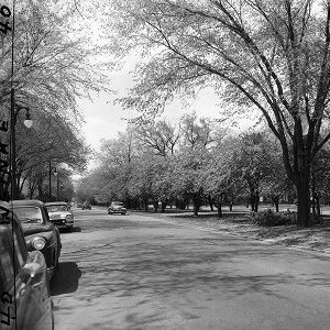 | ||
Broken_main Member Username: Broken_main Post Number: 1364 Registered: 06-2005 |
Durango, I knew the Tonn Family, and yes the Pastor did pass away a little more than 15 years ago. He was killed at Rouge while walking his dog. I can't remember what my godmother taught. She did stay on Oakman though, next door to the Tonn's | ||
Carptrash Member Username: Carptrash Post Number: 1500 Registered: 10-2003 |
Pipp's "Men Who Have Made Michigan" (1927) has two pages on Robt. Oakman, one text and the other a full page photo, but I can't figure out how to scan it small enough to fit here. Not the text anyway. If you are interested let me know. eeeeek | ||
Jjaba Member Username: Jjaba Post Number: 5760 Registered: 11-2003 |
Cartrash, congratulations on 1,500 quality posts. Welcome to the new members also. Swede1934, jjaba only rode the Oakman Streetcars from Ewald Circle East to Manchester Yards in HP. Don't know when they crossed over your bridge. The road to Willow Run was called Detroit Industrial Expressway, built for WWII. Yes, in the 1950s, it was renamed I-94. jjaba, Proudly Westside. | ||
Kathleen Member Username: Kathleen Post Number: 2642 Registered: 10-2003 |
Terrific thread!! I've been reading along for the last couple days and now I finally got a chance to pull out my Oakman Blvd. file, which contains articles dating back to 1916, most found during research at the Burton Collection several years back. To answer one question posed about the relationship between Robert Oakman and Charles Oakman....According to a Detroit Times article dated May 26, 1960, Robert Oakman was Charles Oakman's uncle. Here is the complete text of that article... Oakman Blvd.—a Pioneer’s Dream By Hazel G. Robinson "To the average motorist, Oakman Blvd. is likely to be just a direct route from Highland Park to Dearborn. To the older Detroit area resident it is a bit of nostalgia, a reminder of Detroit’s sprawling growth. But to the nature lover it is something special – an outdoor garden 150 feet wide and 11 miles long, a pilgrimage of unusual beauty. Oakman Blvd. was envisioned, developed, beautified and given to the city in the early 1920s by a native Detroiter, Robert Oakman. The project was carried out through the inspiration of his wife, Mamie Moross Oakman, whose family had been associated with the history of Detroit since Revolutionary War days. It was her grandfather, Joseph Moross, who had, much earlier, built a closer-in, circling route of the city--Grand Blvd. Charles G. Oakman, general manager of the City-County Building, tells of "Uncle Bob's" vision and courageous faith in Detroit. He tells how, in 1917, his Uncle Bob began acquiring the 3,000 acres of farm and marsh land on the city's outskirts to form the route which would link Highland Park from near Woodward avenue to Michigan avenue in what then was Springwells Township. He tells of Henry Ford’s interest in the project because it would provide a shorter route from the Ford plant in Highland Park to the then-new Rouge plant. Walter Meyers, administrator of the department of parks and recreation, worked on the project. He explains that the boulevard was to be primarily a residential thoroughfare with hundreds of islands planted with specimens of each variety of tree and ornamental shrub grown in this climate. And he proudly displays those original invoices, listing 400 American-grown flowering cherry, crab and peach trees. Many other varieties have been added through the years but there has been strict adherence to that original planting scheme. To see it at its best, start at Oakman Boulevard, beginning at Linwood any day in early June, and follow its curves westward. You will see the thick, twisted trunks of those orchards and the gnarled trunks of arbor vitae, all indicating age. You will see masses of blooms, the nice blending of lavender of the 30-year-old lilacs with the purple of flowering plums. There will be the yellow tint of flowers on the big, red barberry bushes and the fill-ins of huge snowball clumps. If you have caught the right day and week of the season, a gentle breeze will strew your path with a carpet of pastel petals. It’s when the route passes through Old Dearborn that you will see the majestic elms which spread their branches to form a mile-long canopy, and the hundreds of white pines standing spindly and erect, reaching for the sunlight. It is here that the pattern of the planting extends to the wide and deep residential lots of the charming old houses. Here the ivy grows tall on the chimneys, and high arbored entrances to clipped hedges give glimpses of more beauty at the rear. Robert Oakman names this the Aviation Field Subdivision – the name itself being prophetic of the age to come. At Michigan avenue smoke stacks in the distance indicate you are easing into a different world, a world of industry. Railroad tracks, gates, viaducts and merging highways mark the end of Oakman Boulevard.” | ||
Kathleen Member Username: Kathleen Post Number: 2643 Registered: 10-2003 |
From the April 22, 1916 issue of Detroit Saturday Night: Detroit Gets a Much Needed Outer Boulevard The publication of the map showing the route of the new Ford Highway in last week’s issue of Detroit Saturday Night created a sensation in the downtown district. News stands were besieged by real estate operators and prospective investors and every available copy of the paper was bought up. The route, outlined in red ink, strikingly presented the exact location of the great highway and its authoritative publication set at rest many erroneous rumors of the sections the new boulevard would traverse. Robert Oakman, founder of Ford Highway, is receiving congratulations from the business community on his noteworthy enterprise. Ford Highway is the creature of Mr. Oakman’s individual initiative and though at times semingly [sic] insurmountable obstacles stood in his way, he persisted until the entire right of way was procured. Ford Highway, it will be remembered, will extend from Woodward Avenue, at a point opposite the Ford Motor Car plant, to Fort Street, at the site of the Ford Tractor plant. It will be 150 wide, improved, and will carry a double track street railway line. Thus the Ford Highway line will intersect and connect up the Woodward, Hamilton, Grand River, Warren, Michigan, Fort, and River Road lines running into the heart of the city, and will make it unnecessary for dwellers in the west and northwest sections to come down town to transfer to outlying points on the lines mentioned. That the crime of Detroit’s Grand Boulevard may not be repeated on Ford Highway, Mr. Oakman has adopted rigid restrictions that will effectively segregate business from residential sites. Where residences are to be located on the Highway, business or industrial institutions will not be permitted to encroach. Mr. Oakman controls all of the frontage on the Ford Highway, from the Ford property on Woodward Avenue to the Ford property on Fort Street. In addition to this, Mr. Oakman has a number of Ford Highway subdivisions which give the prospective investor wide latitude in the selection of home, business and industrial sites. Ford Highway will be one of the most vital factors in the creation of a Greater Detroit, because it makes accessible a vast amount of highly desirable land which thus far has been unavailable because of the lack of street railway transportation and proper boulevard facilities. The highway traverses sections immediately adjoining the city limits, the entire right-of-way being within the six-mile circle. Detroit has been talking of an outer boulevard for a number of years. It was first proposed at a time when the necessary right of way from river to river could have been obtained for a mere fraction of what it is worth today. But the city did not move and were it to attempt to condemn its way through for such a boulevard today, it is quite likely the cost would prove prohibitive. Robert Oakman, however, did for the city what the city has not seen its way clear to do for itself." | ||
Royce Member Username: Royce Post Number: 2453 Registered: 07-2004 |
There is a Robert Oakman Building at the corner of Oakman Blvd and Grand River. It was built in 1929. Looks like only the ground floor is used, but the overall building looks to be in good shape. | ||
Gannon Member Username: Gannon Post Number: 11123 Registered: 12-2003 |
I daresay they weren't peach trees, but rather PEAR trees. I think peaches need a warmer climate, say like Georgia. We had one in our Appoline backyard...have one of those horrible childhood memories of a worm in one...cannot say how far back that goes. Otherwise, great articles! What a cool thread. | ||
Bc_n_dtown Member Username: Bc_n_dtown Post Number: 36 Registered: 09-2006 |
Thanks Kathleen for posting those two newspaper articles. They helped to answer a number of my questions, especially on the relation between Robert and Charles. I do find this Robert and Charles mix-up thing kinda humorous though. Even the highly respected book by the CERA done on the D.S.R. (Vol II: 1922-1956) mistakenly names Charles Oakman in an article on the beginnings of the streetcar line, and in a 1925 photo taken along-side a Northwest Belt Line streetcar. That would have placed Charles Oakman at 15 years old when the Oakman (Northwest Belt) streetcar line was built in 1918—highly unlikely that it was Charles, who was born in 1903. Which brings up another question: The year of Robert Oakman's death. Does anyone have an accurate date? A couple of online sources place his death in 1973, which ironically was the same year Charles passed. This creates a problem for me because some months ago I copied a few pages from an old book at the DPL that had a chapter on Robert W. Oakman. It stated that Robert Oakman died in 1942. It also mentioned that before he had died he dedicated his entire boulevard to the City of Detroit, and even agreed to pay half the costs of paving it. Is this 1973 date another mix-up between the two Oakmans? | ||
Leoqueen Member Username: Leoqueen Post Number: 1676 Registered: 07-2004 |
WOW!This is indeed a great thread! Leoqueen grew up in 15614 LaSalle, between Pilgrim and Hughes [it turned into the Lodge Freeway service drive]. When I was about 15 I found the deed to my parents house that stated that it was a part of Robert Oakman's Fenkell Subdivision, Lot 213. For some reason that designation seemed magical to me. My parents and older sister moved to this house in 1949, after living several years on McPherson. When they first got there [I wasnt born until 1954] the Lodge Freeway had not been completed. Like Jjaba, I spent many hours at the Parkman Branch Library. My friends and I would walk down Linwood to Oakman to the library; to this day I can still smell the 'library fragrance'...old books and intelligence. On the way to the library we passed St Francis Home for Boys; I always wished that my parents would send my brother there.I have really special feelings for the Bell building on Oakman. When we would go on family rides and passed it, I impressed my parents with a weather report. They didnt know, like I did, that the telephone on the sign would glow in different colors to signify the weather. I had seen the legend in the yellow pages and memorized it. When the building finally closed and the sign went dark , that was a sad day for me. I used to enjoy watching the sign painters change the ads on the HUGE vertical billboard on Oakman and 12th, just west of the Bell Building and on top of the Hostess Cake building. They actually PAINTED it, unlike now, when they just stretch a preprinted cloth on it. Man, they were good. First they did a line drawing, then they painted it. Cool. Years later when I had one of those sign painters in classes at CCS. His name was Leonard, and he told me all about painting those signs! He went back to school for painting, and his work was stylistically done in the same manner as the outdoor signs. We had great talks. He told me about painting big tomatoes and the like.I always envied people who lived on Oakman. Those big houses were gorgeous. After library visits I would roam around looking at them, dreaming. | ||
Bc_n_dtown Member Username: Bc_n_dtown Post Number: 37 Registered: 09-2006 |
Thanks Hornwrecker for the info and that great photo of Robert Oakman ...I'd love to use that photo of him on my web-site when I post my article on Robert Oakman and his streetcar line, probably sometime after the new year. In answer to Msamslex's question on the Aviation Subdivision map posted by Hornwrecker.... quote: According to a couple of my maps, prior to the 1920's they show that the Greenfield we know today had two different names. Where it bordered Greenfield and Redford Twps southward from Eight Mile it was known as Greenfield Road. Where it bordered the townships of Dearborn and Springwells (where the aviation subdivision was located)—starting at either Joy Road (Bonaparte) or Tireman (hard to tell on map)—it was known as Division Road. Although not visible on the above map, in addition to the diagonal Greenfield Blvd (today known as Littlefield) there was also a Springwells Blvd (known today as Esper), both of which intersected at Tireman onward into Detroit. Evidently the two roads were named after the former townships where the two roads traveled through. | ||
Leob Member Username: Leob Post Number: 103 Registered: 10-2005 |
There was indeed an Army Air Core airfield in the Aviation tract. My G.G. Grand parents were Espers for which one of the transverse airstrips was named - as it became a boulevard. My grandmother once told the story of how a biplane lost a prop after takeoff to the Southwest it twirled to earth in her backyard (Schaefer and Haggerty) and the plane crashed further west on Mr. Ford's farm. Leo B | ||
Bc_n_dtown Member Username: Bc_n_dtown Post Number: 38 Registered: 09-2006 |
Obviously, Robert Oakman was prominent in Detroit even prior to his subdivision being built. Old Detroit maps prior to the 1920's show that during that time the current Woodrow Wilson street, north of Webb, was named Oakman Blvd., while south of Webb it was known only as Wilson street. The stretch of the current Oakman Blvd between Hamilton and Linwood was known then as Metzer Road. After Oakman's Ford Highway was renamed Oakman Highway (later Boulevard), the former Oakman and Wilson streets were renamed after President Woodrow Wilson. |