Eastsideirish Member Username: Eastsideirish Post Number: 2 Registered: 03-2009 |
I got a hold of an Atlas published in 1876 entitled "Illustrated Historical Atlas of Wayne County Mich. 1875" (see picture attached). This atlas contains detailed maps of all Townships within Wayne County in 1876, including former Springwells, Hamtramck, Greenfield and Grosse Point Townships, all of which were later annexed into the City of Detroit. I will attach a few of the photos I have taken, but will also make high resolution scans. Let me know if this is of interest to anyone else besides me.  | ||
Mikeg Member Username: Mikeg Post Number: 2296 Registered: 12-2005 |
Welcome to the forum and thanks for the offer, but the following information will save you a lot of work. The U of M Library already has many of the early Michigan County Atlases available on line from here. Your 1876 Wayne County Atlas can be viewed and searched from this page. | ||
Eastsideirish Member Username: Eastsideirish Post Number: 3 Registered: 03-2009 |
Here are more pictures from the Atlas. 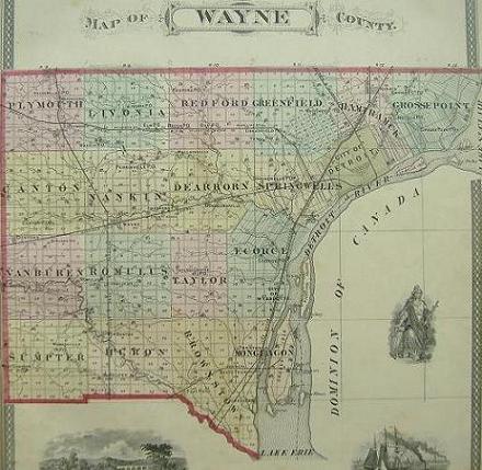 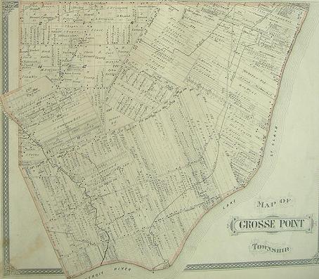 | ||
Jams Member Username: Jams Post Number: 7940 Registered: 10-2003 |
Be nice,Gnome. | ||
Gazhekwe Member Username: Gazhekwe Post Number: 2997 Registered: 08-2007 |
I love books like this. You can get lost for hours wandering the back roads and finding the old communities, like Beech and Oak. | ||
Gnome Member Username: Gnome Post Number: 2526 Registered: 08-2007 |
I'm not saying anything about anything. Welcome to the forum, EastsideIrish. | ||
Eastsideirish Member Username: Eastsideirish Post Number: 4 Registered: 03-2009 |
Thanks a lot Mike for the link to the searchable thumbnail pictures. Where do you (or anyone) search for something as detailed as the attached picture? Please let me know, that would be fascinating. 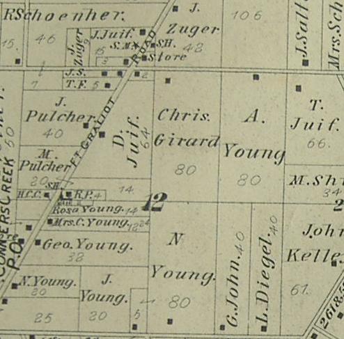 | ||
Novine Member Username: Novine Post Number: 1276 Registered: 07-2007 |
Eastsideirish, what your source for the atlas? | ||
Gnome Member Username: Gnome Post Number: 2527 Registered: 08-2007 |
I'm jealous over your book ESI, you have a very cool piece of history. How did you get it? | ||
English Member Username: English Post Number: 499 Registered: 10-2003 |
Thanks for posting! *now lost in a fantasy world where all the crazy annexation didn't happen...* | ||
Lowell Moderator Username: Lowell Post Number: 2262 Registered: 09-2003 |
Welcome to the forum Eastsideirish and thanks! | ||
Mikeg Member Username: Mikeg Post Number: 2297 Registered: 12-2005 |
quote: Here is how to navigate the U of M site to get to a high-resolution image that includes Section 12 of the Grosse Pointe Twp. map: Click here to Search or Browse the U of M Library's "Michigan County Histories and Atlases" collection of 428 titles. Click on the "Browse Michigan County Histories and Atlases" link on that page and you can then browse all 428 titles which are arranged alphabetically. Click on the "I" and scroll down to find the link to "Illustrated historical atlas of the county of Wayne, Michigan / H. Belden & Co." Scroll down on the page that opens and click on the link that says "Page 3 - Comprehensive Index". Click on the Page Size "+" to enlarge the image and you will find that the Grosse Pointe Twp. map is on Page 7 of the Atlas. Use the drop-down menu to find and select Page No. "7". A JPG image of the map will then appear. Select "PDF" instead of the default "image" in the "Format" drop down menu and a high resolution version of the map will appear, which you can enlarge much more than with the Page Size "+/-". You can save the PDF map image to your hard drive for future reference. To create an image like the one you posted of Section 12, open the PDF file, enlarge the map image to the desired size and then use your keyboard's "Prt Scr" key to copy a screen shot of the map to your clipboard (or you can use the PDF cursor select tool to click and drag a rectangle over the portion of the map you want to copy to the clipboard). Paste the clipboard image and crop it using your image editing software and then save it to your hard drive. You can then upload your blown-up image of Section 12 to your post on DetroitYes. (Message edited by Mikeg on March 23, 2009) | ||
Mikeg Member Username: Mikeg Post Number: 2299 Registered: 12-2005 |
Here is an image I made of Section 12 from the U of M Library site using the instructions I provided. Section 12 includes the community named after its Post Office, "Conners Creek". The church symbol indicates the location of Assumption Grotto R.C. Church. Besides the P.O. and Church, Conners Creek boasted a Store and School House. 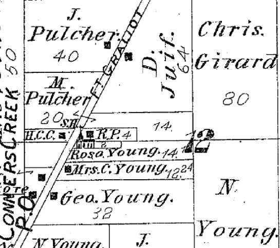 (Message edited by Mikeg on March 23, 2009) | ||
Reddog289 Member Username: Reddog289 Post Number: 1000 Registered: 08-2007 |
Thanks for shakin my memory bout them maps. Found the drain behind my house{now covered} was "longer" back then. | ||
Cynthia_dudal Member Username: Cynthia_dudal Post Number: 3 Registered: 03-2009 |
CYNTHIA DUDAL IS A NEW MEMBER. | ||
Danny Member Username: Danny Post Number: 4570 Registered: 02-2004 |
I wish Detroit could annex all of the townships of Ecorse, Hamtramck, Grosse Pointe, Redford Livonia, Nankin and Taylor; then Detroit would be 15 times bigger than the present shape we live today. | ||
Danny Member Username: Danny Post Number: 4571 Registered: 02-2004 |
Most of the street signs in Detroit ghettohoods are named after families who lived in the farms after they contribute their properties to sub-divisional developers. | ||
Eastsideirish Member Username: Eastsideirish Post Number: 5 Registered: 03-2009 |
Thanks Mikeg! You have impressed and helped us all. I've been posting a long time on detroityes.com (this is a new Username for me), and I never knew about this book being online with the U of M Library. Thanks again, you deserve full recognition for knowing this information. I still like having the Atlas, however. 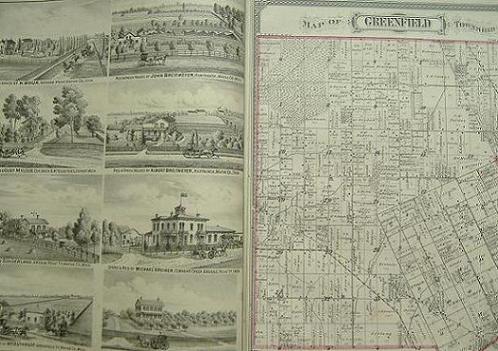 | ||
Gistok Member Username: Gistok Post Number: 6256 Registered: 08-2004 |
Thanks for all the cool info and welcome Eastsideirish!! From looking at the map of Grosse Pointe Township, one can easily see just how the ribbon farms affected all of the peculiar east side street patterns. The route of eastside streets such as Kelly, Moross, Hayes, Chalmers, Morang, Cadieux and most of all Harper were all dictated by the changes in the angles of the ribbon farms. Harper is the street where the east side ribbon farms all changed compass orientation, which may have factored into why it was a logical choice for the route of I-94. Farther north Kelly Ave. took over this feature. Very interesting maps! | ||
Eastsideirish Member Username: Eastsideirish Post Number: 8 Registered: 03-2009 |
Thank you Gistok. But please give Mikeg much credit and recognition for telling us all how this Historical Atlas can easily be viewed online. Although having such a prestine original copy that you can physically browse is still pretty neat in my opinion. Call me old fashioned. Yes, the street layout was dictated by the angles of the ribbon farms, which dictated the layout of the pattern of sewer lines-water mains. I-94 followed a "path of least resistance" in regard to the sewer lines-water mains (each of which had to be cut and re-ran under the new expressway...affectionally known as "The Ditch" to the Eastsiders who witnessed it being built). Harper Avenue marked the re-angling and branching out of many, many sewer lines-water mains, so it was economical on many fronts to cut and tunnel the pipes (build I-94) along these "ancient" boundary lines. I wish I could upload bigger, clearer more detailed pictures for discussions regarding particular areas, but the 50k attachment limit is killing me. 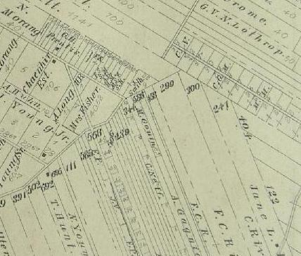 | ||
Guideboat Member Username: Guideboat Post Number: 49 Registered: 02-2008 |
ESI, I think someone else asked this but where did you acquire the atlas, or did you inherit it? A book like that would be very easy to get lost in. Thanks. And thanks for the link to the e-site Mikeg. | ||
4oranges Member Username: 4oranges Post Number: 32 Registered: 07-2008 |
If one were to follow Mikeg's instruction, and went to page 50 of the atlas, by what other name would the region immediately to the west of what is shown be called? Not much, just say another 5 miles to the west along Michigan Avenue? I am not familiar with historical street names...suppose I could look it up but if anyone already knows and can share what the current street names are for those formerly numbered streets, that would be cool too. | ||
4oranges Member Username: 4oranges Post Number: 33 Registered: 07-2008 |
Ah. Never mind. Springwells. Right there in ESI's first few scans. | ||
Mikeg Member Username: Mikeg Post Number: 2301 Registered: 12-2005 |
I agree with Eastsideirish, a hard copy beats a bunch of electrons any day! I've had a book containing reprints of the 1859, 1875 and 1895 Macomb County Atlases that I bought back when it was published by the St. Clair Shores Historical Commission in the early 1980's. How much better it would be to have the originals in my hands, I can only guess. BTW, the 1859 Atlas Wall Map for Macomb and St. Clair Counties has been digitized by the Clinton-Macomb Public Library and can be viewed here. Here you will find the U of M Library's 1916 Macomb County Atlas. | ||
Eastsideirish Member Username: Eastsideirish Post Number: 9 Registered: 03-2009 |
I got it from a friend in Grayling, MI. He was my roommate in college. He was very condescending toward the fact that I grew up in Detroit (I lived near E. Warren and Cadieux). It drove him crazy that no matter how much he put down Detroit, or being from the city, I would always just laugh at him and say he was a hick. We would go back and forth about small town vs. big city, and it would get very vicious and nasty at times. However, we maintained a very strong friendship out of a mutual respect for each other. Anyway, after kayaking down the Au Sable one day, we were eating dinner at his house in Grayling, and I noticed two things placed safely near his fireplace: this Atlas of Wayne County 1876, and an original Civil War Union soldier discharge paper. I jokingly asked if he wanted either of them, and he said "You can have that Atlas. Who wants a old map of a crappy city, anyway?" I stayed very calm and just said "Okay, thanks." What a hick. The Atlas is very large-sized and in excellent condition. His family was from the Flat Rock area, and brought the Atlas with them when they moved to Grayling when my friend was around 9 years old. Now, if I can only get that original Civil War document...  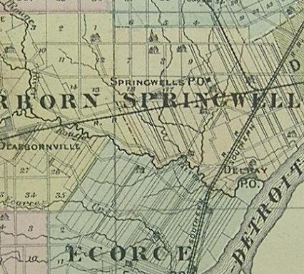 |