Lowell Board Administrator Username: Lowell Post Number: 861 Registered: 10-2003 Posted From: 66.167.212.48 |
Tell me about it. While researching for my newest webisode Paradise Lost: Lakeside Trailer Court, I discovered that the burned out structure to the east appears as the US Marine Hospital on my 1943, 1967, & 1982 roadmaps, and as the US public Health Hospital on my 1995 AAA road map. So what's the story? | ||
Eastside Member Username: Eastside Post Number: 7 Registered: 01-2005 Posted From: 68.40.55.11 |
Couple years ago we had our sea-doo at the marina there. Good people there. We loved getting up on steamy summer sat. mornings, stopping at the market on Jefferson for steaks and heading over to Peche Isle for BBQ and swimming. It is truly a unique Detroit experience. | ||
Imperfectly Member Username: Imperfectly Post Number: 27 Registered: 06-2004 Posted From: 68.42.185.189 |
i would love to hear more about this area since i live about 5 blocks north of alter in GPP. | ||
Rrl Member Username: Rrl Post Number: 256 Registered: 12-2003 Posted From: 63.172.198.250 |
There was indeed an old VA hospital not far from the Lakeside Trailer Court at the foot of Alter. I believe it was closed in the 70's, but stood abandoned, (as is typical) for about 10 years. I grew up eastside, and in the early 80's, many people I knew used to run through the place, early urban archeology. Unfortunately, I never made it in, but had heard stories that the place was left with much of the supplies in it; old beds, wooden wheelchairs, cabinets w/ gauze & bandages. It was referred to as the Insane Asylum, as supposedly it was pretty spooky inside. I think it finally had an appointment with the wrecking ball sometime in the mid to late 80's. | ||
Mikem Member Username: Mikem Post Number: 1051 Registered: 10-2003 Posted From: 68.43.13.146 |
The CULMA collection has some pictures of it online: 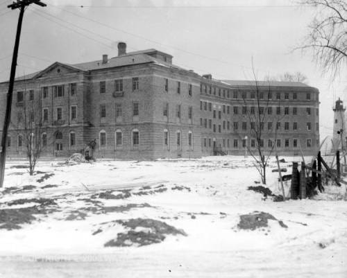 There's another showing a military flag raising, probably during the dedication ceremonies. Looks to be a depression-era public works project, but I'm not sure of the exact date it was built. I think it opened as a Marine Hospital first and later became a Public Health Service hospital, similar to the state hospitals in Pontiac, Traverse City, etc. Someone I knew who lived in the trailer park said, "you could hear the screams of the insane at night", but that sounds like urban legend, doesn't it? I can't remember when it closed, but kids would sneek in afterward and come back with stories of creepy looking medical equipment left in place. I'm leaving town for a few days, but if I think of more, I'll post from the road. | ||
Mikem Member Username: Mikem Post Number: 1052 Registered: 10-2003 Posted From: 68.43.13.146 |
Oh, there used to be a sea-plane base there too, but I don't know if it had any connection. | ||
Lowell Board Administrator Username: Lowell Post Number: 864 Registered: 10-2003 Posted From: 66.167.212.48 |
That's interesting MikeM. I have seemingly misidentified that building on my minittour at the left. This is huge. Was it adjacent to the Trailer Court? From that picture it almost looks like it could have been on the footprint of the trailer court itself. Originally someone said the building I show was in its latter days an elder care building [it does have shuffleboard courts] and maybe it was. It appears to have been a residence. Back to the books. | ||
Lowell Board Administrator Username: Lowell Post Number: 865 Registered: 10-2003 Posted From: 66.167.212.48 |
My 1929 City Guide indicates that there were eleven residences on the street, Riverside Blvd., which by the numbers must extended into what is now Albert Brush Ford Park. Only the burnout at 14645 remains. | ||
Det313grrl Member Username: Det313grrl Post Number: 4 Registered: 01-2005 Posted From: 165.247.231.40 |
You say there "were" eleven residences. Has the trailor park closed? | ||
Det313grrl Member Username: Det313grrl Post Number: 5 Registered: 01-2005 Posted From: 165.247.231.40 |
Just curious Lowell, my younger brother had lived in that trailor park. | ||
Lowell Board Administrator Username: Lowell Post Number: 866 Registered: 10-2003 Posted From: 66.167.212.48 |
The eleven residences was in 1929. The trailer court had to be a later event. I would venture to guess during WWII when housing was at a premium? | ||
The_rock Member Username: The_rock Post Number: 485 Registered: 11-2003 Posted From: 68.42.250.243 |
My only recollection of the hospital was visiting a patient there back in about 1963-4 in connection with a workers compensation case. As I recall then, it was a pretty old facility and I don't think it stayed open much longer, sat dormant and boarded up for a few years and then faced the wrecker's ball. There was a nice old home adjacent to the hospital which I believe in later years served as the clubhouse for the Windmill Pointe Yacht Club. Wish I could be of more help, but Mikem seems to have a good handle on the place. | ||
Mikem Member Username: Mikem Post Number: 1053 Registered: 10-2003 Posted From: 66.94.16.25 |
I'd be interested in any history anyone finds on the Marine Hospital network. I was under the impression this was a hospital for Merchant Marines, similar to a VA hospital. Also, I thought I read that the hospital moved to this location from elsewhere in the city; from a location previously occupied since before the turn of the century. Lowell, the building was located east of the trailer court. It was the first thing you saw when you reached the end of Alter and turned onto Riverside. A new park has been built on the site. In the photo I posted you can see a lighthouse in the background; that is still there where the new park is. I misspoke earlier - the photo is from the Virtual Motor City collection. However, check the aerial photos at the CULMA site. You should be able to find the hospital in any of them. MikeM, reporting from The Allerton Hotel in Chicago, imagining it were the Book Cadillac. | ||
Mikem Member Username: Mikem Post Number: 1056 Registered: 10-2003 Posted From: 66.94.16.25 |
Lowell, I took a quick look at the webisode...the "recently upgraded city park" is the "new" park I was referring to. That's where the hospital was. Try this link : http://www.topozone.com/map.as p?lat=42.35778&lon=-82.93 and see if you can identify the hospital building. The USGS has not updated this topo chart to remove the demolished hospital. BTW, the island behind the burned house and store is Klenk Island, and Harbor Island is the next one to the west. The building with the shuffleboard courts was the city's Lakewood (or Lighthouse) rec center. Probably one of the 11 residences from 1929? | ||
Lowell Board Administrator Username: Lowell Post Number: 869 Registered: 10-2003 Posted From: 66.167.212.48 |
You are correct MikeM. Here is is from the CULMNA collection in 1949. One can see this is from the era before big mobile homes and double wides. 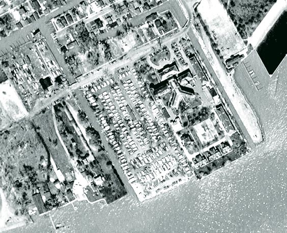 http://techtools.culma.wayne.edu/media/wayne/1949/ha-2-73.pdf | ||
Lowell Board Administrator Username: Lowell Post Number: 870 Registered: 10-2003 Posted From: 66.167.212.48 |
Stil there in 1981...Note bigger mobile homes and creative use of shoreline for parking in all. 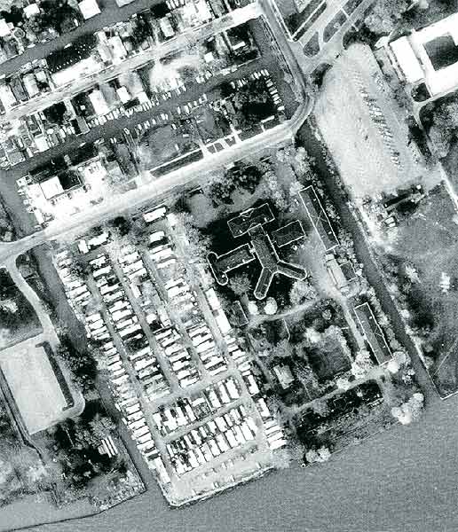 Gone by 1997...  | ||
Mikem Member Username: Mikem Post Number: 1057 Registered: 10-2003 Posted From: 66.94.16.65 |
Thanks Lowell, for digging up the aerials. I never remembered seeing the smaller buildings (staff housing?) near the river. I'm on a handheld device right now so I can't see the aerials very well, but in that first one, do you see airplanes parked next to the shore near what looks like a boat launching ramp, to the west of the trailer park? | ||
The_rock Member Username: The_rock Post Number: 499 Registered: 11-2003 Posted From: 68.42.250.243 |
Those airplanes might be the first of the new A330 Airbuses that NW is buying to replace the reliable old DC-10's. Well, on closer inspection, I guess not. | ||
Jjaba Member Username: Jjaba Post Number: 1217 Registered: 11-2003 Posted From: 24.22.6.155 |
The Rock can find one of the new A-330 NWA Airbuses at the Narita, Japan gate at PDX, Portland, Oregon. They just introduced this service and are running great specials to all over the Orient after landing in Japan. Thanks for the aerial photos and the research on the subject. It is nice to see that the land was put to good use as a park. jjaba; but Rock, don't go Eastside on me. | ||
Lilpup Member Username: Lilpup Post Number: 72 Registered: 06-2004 Posted From: 205.188.116.195 |
There's a brief history and overview of U.S. Marine Hospital system (forerunner of Public Health Service) at Nat'l Library of Medicine. The timeline there lists "1969 Detroit and Savannah Hospitals converted to clinics" and in another section says "in 1981, as part of the Reagan Administration's budget cuts for the Department of Health and Human Services (renamed in 1980), the last of the Public Health Service hospitals and clinics were closed as PHS operations." Detroit's first Marine Hospital, at Mt. Elliot and Jefferson, is described here and here(below the description of Cleveland's facility). (Message edited by lilpup on January 28, 2005) | ||
Gary Member Username: Gary Post Number: 27 Registered: 02-2004 Posted From: 66.73.238.2 |
Mikem...my dad is retired from the U.S. Army and when I was a kid, our family went to the Marine hospital for all out (free) health care needs. This was in the days when Fort Wayne was an active military base. The hospital serviced the active duty and retired military personnel in the Detroit area. I spent 2 days in that hospital during the middle of the '67 riots when I severely broke broke my right arm, which required surgery to repair. I'll never forget it. The hospital also housed wounded Vietnam vets from the Detroit area during that time. The name "Marine Hospital" was changed to USPHS Hospital at some point. The medical staff was comprised of USPHS doctors and nurses who wore uniforms and insignia similar to those of the U.S. Navy. The in-patient hospital facilities were closed in (I Beleive) the late 60s, but the out-patient clinic, lab, dental clinic, and pharmacy remained open for a time. Eventually, the facility housed a methadone (sp?) clinic before closing altogether in the early 70s. I have a lot of memories of that old hospital. BTW...the "screams at night" you mentioned are no urban legend, they were real. I heard them both nights that I spent in that hospital. I was 13 at the time and they scared me half to death. No shit. (Message edited by gary on January 28, 2005) | ||
Mikem Member Username: Mikem Post Number: 1062 Registered: 10-2003 Posted From: 208.54.15.129 |
Thanks, Lilpup, for your research. Looks like a long, complex history behind the Marine/USHS hospital network. I'm glad my memory serves me correct that the hospital was located elsewhere, and I was going to say it was in the vicinity of the Coast Guard station. Gary, thanks for the story. You didn't break your arm misbehavin' during the riot, did you? Were you an eastsider? I remember the methadone clinic as well, now that you mention it (not from personal experience); I think it contributed to the bad rap of Angel Park. | ||
Lowell Board Administrator Username: Lowell Post Number: 882 Registered: 10-2003 Posted From: 66.167.212.48 |
Great posts Lilpup and Gary. I love this forum for getting at the real story that starts out by my mistakenly thinking the Marine hospital [that's where it appeared on one map!] was on the other side of the trailer court. I had no idea! | ||
Gary Member Username: Gary Post Number: 29 Registered: 02-2004 Posted From: 66.73.238.2 |
Mikem...LOL, no the broken arm was the result a bad fall while swinging from a "Tarzan rope" that my brother and I had rigged up in a tree in our back yard. My parents were not the type to allow for anything even resembling "misbehavior". I was a west sider from the U of D neighborhood. I guess it was mentioned in a previous post that the hospital was situated at the foot of Alter Rd. on the river. It really was a beautiful spot back in its day. Hi Lowell...I met you a couple of times at the Soulful Detroit Forum get togethers on Woodward in Ferndale. I'm the "tall black guy". I have just recently started actively posting over here, after lurking around these parts for a couple of years now. Great site. | ||
Lowell Board Administrator Username: Lowell Post Number: 885 Registered: 10-2003 Posted From: 66.167.212.48 |
Gotcha Gary. Good to see you 'over on this side of the fence'. I missed the last SD get together, night before my exhibiton too busy, but hope to get by the next month. | ||
Mikem Member Username: Mikem Post Number: 1063 Registered: 10-2003 Posted From: 68.43.13.146 |
OK, now that I'm back home on a more capable computer, I rounded up some more photos of the area from Virtual Motor City. Here's the dedication ceremony, sometime before the war: 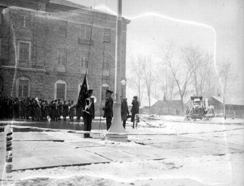 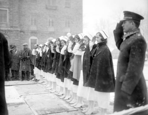 Here's the area before the hospital was built. This first shot is Windmill Point looking northeast over the future Grosse Pointe Park. People are swimming next to where the Fox Creek empties into the river. You can see the old, steep bridge over the Fox Creek. The bridge turned over the top of the creek, i.e., a curved bridge and I remember you had to drive slowly over the bridge to keep from bottoming out and to keep from side-swiping a rowdy teen in his muscle car, coming from Angel Park. To the left of the creek are antennas for (probably) a marine homing beacon, the taller of a pair of range lights, and the lighthouse that is visible in the backgound of the picture I posted at the top of the thread: 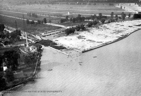 Here's are two more aerial views of the future hospital land. Top right in the first is the curved bridge, then the two range lights, and below them, the lighthouse. I have the feeling that this lighthouse was moved farther west, or a new one was built farther west, and another picture in the archives shows the Windmill Point Light being dismantled brick-by-brick. It looks too close to the creek to fit the hospital on the land and still be able to see it in the first photo of the thread. Next to the light "house" is a riverfront hangar, and I can see a floatplane parked just outside (especially on the larger versions of the pictures in the archives). Also in the archives, when doing a search on Windmill Point, there are two pictures of the Scripps airplane on the river with "Wm. Scripps driving & John Dodge passenger". Left of the hangar is a Georgian looking home which is the Old Detroit Motorboat Club - maybe what the Rock was thinking of? 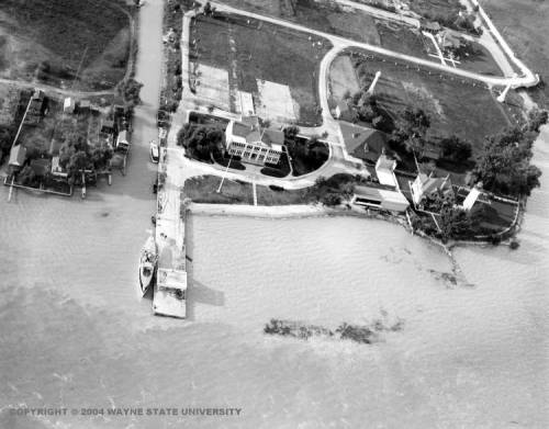 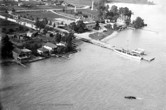 Amazing how an area can change so much. I'm willing to bet the lighthouse was the first thing there and outlasted the club, hospital, and trailer court. | ||
The_rock Member Username: The_rock Post Number: 502 Registered: 11-2003 Posted From: 68.42.250.243 |
Although some call the light house "The Grosse Pointe Lighthouse", it is really the Windmill Point Lighthouse.(The Grosse Point Lighthouse is located in Evanston, Illinois). It was the second one built at this location and was erected in 1933. So I assume that it beat both the hospital and the trailer court by a few years. | ||
Lowell Board Administrator Username: Lowell Post Number: 887 Registered: 10-2003 Posted From: 66.167.212.48 |
Mike, When time were the last two pictures from? Those were two impressive properties. It seems strange that they would be taken down as they are on the trailer park property. The larger one almost looks like a lodging, perhaps for visiting yachts? It also appears that the land was reshaped or the lighthouse moved as it now sits on a corner jutting out into the water. Fabulous shots and another great find by you. | ||
Craggy Member Username: Craggy Post Number: 130 Registered: 10-2003 Posted From: 68.41.75.125 |
Lowell... After that place closed, we'd ride our bikes up there and try to break windows with rocks...we were convinced the place was haunted (I was eleven or so...what can I say). We'd dare each other to go inside, and basically try to scare the living crap out of each other. An intimidating building, to be sure. | ||
Gary Member Username: Gary Post Number: 30 Registered: 02-2004 Posted From: 68.21.37.17 |
Mikem...do you have any clue as to the date of those cool photos depicting the opening day of the hospital? Judging by the uniforms worm by the officers and nurses I would guess that the 1930s would be about right, as you mentionrd in an earlier post. Moreover, the aerial shots showing the area before the hospital was built would tend to support that assumption. We can clearly see the north-south roads of Grosse Pointe Park, with the adjoining land already cleared for development. That area of SE Detroit/GPP would have been an uninhabited wildernes to anyone whose name wasn't Ford, Briggs, or Hudson prior to that time. In Lowell's great aerial shots of the hospital, the northern main section housed the hospital's administrative offices and dental clinic. The middle section with the two wings on either side of the main building housed the in-patient wards on the upper floors. It also housed the pharmacy on the main floor and the X-Ray clinic, medical lab (Lord, how I hated that place), and operating rooms on the upper floors. The south, Y-shaped section was only one story tall, unlike the rest of the facility. The left/west wing housed the out-patient clinic, where I had countless physical exams, and was treated for every childhood ailment imaginable. The right/east side of the Y was where they had the commissary and cafeteria. This is also where the hospital offered a great view of the grounds and the river. Craggy...Even in it's hey-day that hospital could be a very scary place. If you had to go there for unpleasant medical procedures. like shots, X-rays, blood work, and dental procedures like I did as a kid, you'd know what I mean. Still, your rock-throwing expeditions sound like a lot of fun. Wish I'd have been there. | ||
Lilpup Member Username: Lilpup Post Number: 73 Registered: 06-2004 Posted From: 64.12.116.195 |
This 2003 HarleyEllis 95th Anniversary press release indicates that the hospital was built between 1908-1929 (my guess is in 1929):
| ||
Mikem Member Username: Mikem Post Number: 1065 Registered: 10-2003 Posted From: 68.43.13.146 |
Good morning..excuse my typos because it's been a long night! The archives seem to only list the decade in which the photo was taken, and for the dedication ceremony, they say "1930s". The aerial shots, pre-hospital, don't have a date listed, but go to the archives and do a keyword search on "Windmill" and look at the photos at the largest zoom available. The cars look to be late 1920's, but I'm not a car expert. Seems like the empty streets of Grosse Pointe Park's Windmill Pointe would have had several homes by the '20s, but then that area was the "Grand Marais" (Big Marsh) and even today, Windmill Pointe Drive is obviously higher than the inland streets, as if built on top of a low, ancient, shoreline sand dune. The pictures of the Scripps airplane in the archives, which I believe I see in the waterfront hangar, look like the Wright flyer with floats, so possibly these pictures are from the 'teens. How does the Virtual Motor City collection determine the date of the photos? How accurate are they? Lilpup presents evidence that the hospital was built in the late '20s. The lighthouse in the background of the picture at the top of this thread looks similar to the one in these pictures. Cetainly, the shoreline was filled in to build the hospital grounds, but even so, the space between the lighthouse and the Fox Creek looks too narrow for the hospital. However, the archives show this before and after of the Windmill Point Light below, with the dismantling photo dated "1930s". Perhaps the hospital was built in the '20s, and the the lighthouse was demoed in the '30s and replaced with a new one. Just now, I looked at Lowell's webisode of the trailer court again, and find his photo of the present day lighthouse to be an emasculated version of the original; certainly not the same structure. So...the hospital went up in the late '20s or early '30s, the original Windmill Pointe Light came down afterward, and the aerial shots are no later than the mid-twenties. Sound reasonable? 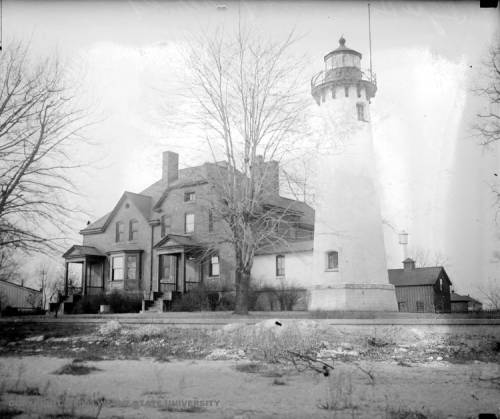 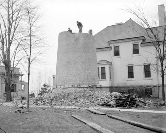 | ||
Lowell Board Administrator Username: Lowell Post Number: 889 Registered: 10-2003 Posted From: 66.167.212.48 |
Great sleuthing MikeM. Looking at the last picture one can see on the left what appears to be the construction of one of the three shoreside buildings of the Hospital. So if the picture is from the 30's maybe that gives us a clue about the construction date. I note the old lighthouse is definitely larger than the present one and was made of brick [the present one appears to be riveted plate metal]. 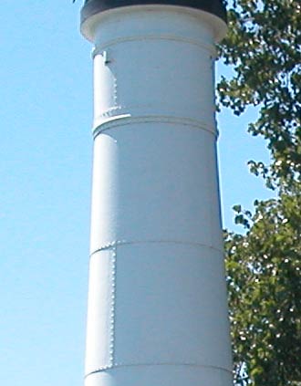 I would speculate that the rubble was removed by boat, judging form the board track in the foreground but, more likely, it was dumped into the river to firm up the shoreline. In the picture above, the building that previously occupied that spot looks like a duplex. I would speculate that it would house the lighthouse keeper. A second tower or some sort can be seen faintly to the right of the lighthouse rising behind the barnlike structure. I wonder what that was. In the aerials there appears to be two of them. Perhaps the whole complex was part of the lighthouse service and always federal land. | ||
Mikem Member Username: Mikem Post Number: 1066 Registered: 10-2003 Posted From: 68.43.13.146 |
The towers in the aerials, one of which you are seeing in the background of the upper picture above, are range lights. The easternmost is taller than the other, and when on the river in a ship, you line up the two so that one light appears directly over the top of the other. When lined up like this, you know you are in the center of the channel. I drew the red line on the map below as a rough estimate of their alignment. These must have been used to guide ships going upbound between Belle Isle and Peach Island. 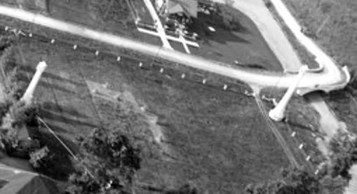 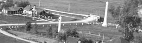 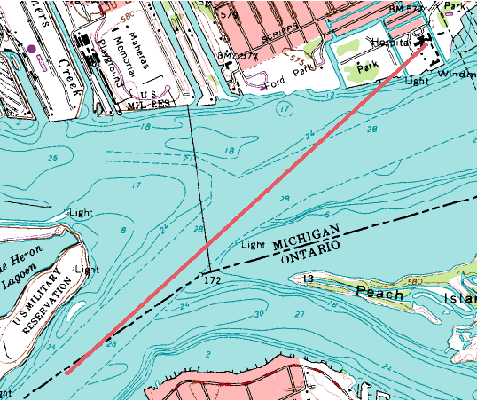 To reiterate, the aerials, were taken after the first flight at Kitty Hawk, but before the lighthouse was torn down in the '30s. The cars, the swimmers, and Scripp's airplane look like late teens, early twenties: 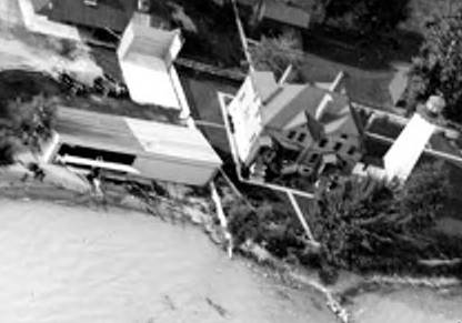 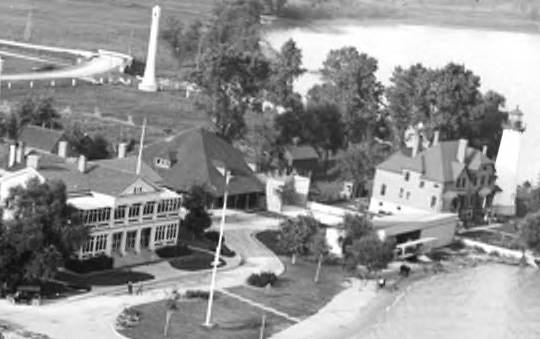 The dedication ceremony pictures are from the '30s, and the hospital was built while the lighthouse was still there. The lighthouse demolition picture is from the '30s, so I say the hospital was built late twenties/early thirties on the land between the range lights. Within a few years, the lighthouse was torn down, the shoreline filled in, and the waterfront hospital buildings were built after that. | ||
Mikem Member Username: Mikem Post Number: 1067 Registered: 10-2003 Posted From: 68.43.13.146 |
Gary and Lilpup, thanks for your contributions. Lilpup's link to Silas Farmer's History of Detroit helped with the discovery of the former location of the Marine Hospital at Mt Elliot and the river. In that link there is this sketch of the old hospital. Compare to this from the WSU Virtual Motor City, a picture of it from the 1960s. | ||
Mikem Member Username: Mikem Post Number: 1068 Registered: 10-2003 Posted From: 68.43.13.146 |
Ah-Ha! I knew this all seemed familiar: Detroit's first commercial airplane builder
| ||
Bindetroit Member Username: Bindetroit Post Number: 561 Registered: 10-2003 Posted From: 69.246.117.31 |
Very impressive historical sleuthing and great photos. Thanks to all who contributed. | ||
Lilpup Member Username: Lilpup Post Number: 74 Registered: 06-2004 Posted From: 205.188.116.195 |
According to the online sources checked, the current lighthouse dates to 1933. It's the 5th constructed/modified lighthouse on the point since the first built in 1838 (1838, 1866, 1875, 1891, 1933). This list states that 'a nearby range light, discontinued in 1931, was relocated to the Lower Nicolet West Range on the St. Mary's River" - possibly one from the above photos? | ||
Lowell Board Administrator Username: Lowell Post Number: 892 Registered: 10-2003 Posted From: 66.167.212.48 |
WOW! Great Zoom on that Verville biplane and conclusions on the range lights. [And we all thought they used the seven sisters] I also like the Arts & Crafts California style bungalow by the Fox Creek Bridge in the second range light picture. It's my bias [becasue I am a addict of the game] but that sure looks like a handball court behind the hangar. I can also see the old light house is connected to the big house by a breezeway giving me even more the impression that it was the light house keeper's residence. The Detroit Motor Boat Clubhouse is impressive too. Daddy Big Buck sort of place. I love the web! | ||
Mikem Member Username: Mikem Post Number: 1069 Registered: 10-2003 Posted From: 68.43.13.146 |
The range lights were constructed in 1891, probably the same time the lighthouse itself was re-constructed. They look exactly like the one on the St Mary's River in Lilpup's link. The present-day lighthouse was built in 1933, and I would imagine they would have built it first before tearing down the older one in the photos above. This postcard shows the structure behind Lowell's supposed handball courts was a picnic shelter. A history book of Grosse Pointe I have (Tonnancour Vol. 1), shows another postcard of the Detroit Motor Boat Club, only it's titled "Light House Inn". It says:
Finally,
| ||
Mikem Member Username: Mikem Post Number: 1070 Registered: 10-2003 Posted From: 68.43.13.146 |
^^^ I just noticed, the postcard at the link in my post above shows the Inn's owner and manager as Wm. C. Klenk. The small island formed by the canals immediately north of the hospital grounds is called Klenk Island, and the sole street on the one-block long island is Klenk Street. Also, Scripps must have lived in the area or had quite an influence there, since Scripps Street is just north of Harbor Island: 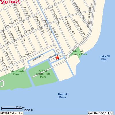 | ||
Mikem Member Username: Mikem Post Number: 1074 Registered: 10-2003 |
A map of the area from before WWI: 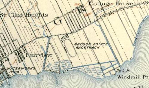 A new sign at the park occupying the old hospital grounds gives a clue as to its previous owner. Note the bottom line: 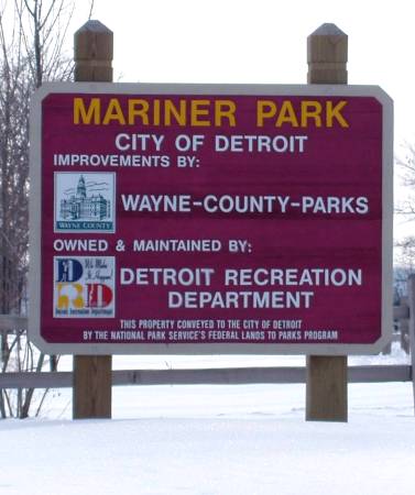 Lowell, here's that bungalow you like in the aerial photo: 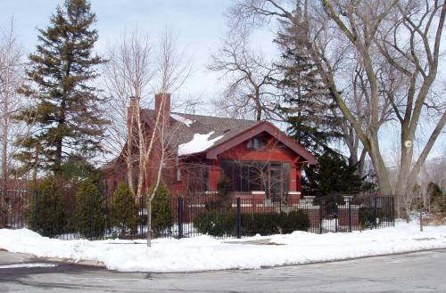 | ||
Pete Prokopowicz (Unregistered Guest) Unregistered guest Posted From: 67.174.15.45 |
Congratulations on a great webisode and discussion. I have no specific memories to add, but the discussion brought up something I have wondered about during the last 35 years of watching Jefferson to the river deteriorate as my family drove into Grosse Pointe. There was a theory that the land was actually tremendously valuable but was being sat upon by speculators, waiting to make a killing. Is there something about tax laws in Detroit that makes it feasible to hold so much potentially prime real estate as it collapses, generating no income, for 35 years or more? Or is the land truly abandonded? How can there be zero demand for it? (Message approved by admin) | ||
mary matthews (Unregistered Guest) Unregistered guest Posted From: 68.40.91.73 |
I am from Grosse Pointe and drove down to the end of Alter a few days ago and saw all of the vacant waterfront land. I can't believe the city lets it sit...With the 2 relatively new housing developments to the west of this property you would think there would be money to be made building some type of housing there. I have become more and more interested in trying to rehab properties in this area and o build new on the vacant lots....It's a shame to let this area become as broken down as it has become...I had no idea there used to be a hospital down in the area..It has been some very interesting reading ..Thanks for the history (Message approved by admin) | ||
mary matthews (Unregistered Guest) Unregistered guest Posted From: 68.40.91.73 |
I looked up the tax books on the vacant properties of Riverside BLVD...The old trailer park is owned by one man and the remaining properties are owned by a second man...I don't know why they are not developing the area....It would be wonderful to see some construction in the area to help revitalize, what I have read on this website , a place that holds a lot of memories to many..Maybe there will be some new memories made there in the future...We will see. (Message approved by admin) | ||
James Amato (Unregistered Guest) Unregistered guest Posted From: 69.47.247.222 |
Great job on your research and pictures guys. Just amazing. I'm impressed. Keep up the great work and thanks so much for the effort you have put forth on this project in progress. To Michael Mooney. Hi Mike. I'm not sure if I know you or not. Maybe you might remember myself and a few of the old timers if I mentioned some names. Anyway it was Al Dury, his wife and son Dale who ran Donna Lee's. Al had closed the grocery store that he also owned next to Donna Lee's. A time later he decided to reopen it so he could sell the place. Al would work the counter and Dale would sit in the back with a shotgun just in case someone tried to rob the place. I know the neighborhood was really bad about that time and we all thought he was crazy to open it up again. Well as fate would have it the store got robbed. The robbers killed Al on the spot. Dale came out of the back of the store firing and I believe he was shot also but survived. I'm not sure if any of the robbers were shot or killed. A very, very sad day for the neighborhood and for Al's family. I really liked Al and he treated all of us guys very well back in those days. He would always let us bring our old warm skunky beer back to him and he would exchange it for fresh cold ones. lol I also talked about old man Price and the Bun in a previous post. A lot of the St. Martin's kids hung out at the Bun. The greaser kids like myself hung out closer to Jefferson but it was a mixture of both groups just the same. Everyone knew each other but we hung out in our little groups. I have a few pictures I'd like to post sometime. I just wish I had more. See ya! (Message approved by admin) | ||
Tim Mooney (Unregistered Guest) Unregistered guest Posted From: 68.43.189.4 |
Hey James A. I would think that our paths must have crossed in the past, as evidenced by your 4/8/05 posting about Al and Dale Dury. I too was more of a greaser and I hung around on "The Avenue," rather than at the Bun. However, I spent countless days hanging around Donna Lee's. Dale was several years older than us and he used to take the gang of us driving around in his brown car, I almost remember the make and model, possibly a Comet, circa 1964 or 1965. When we were about 16 or 17 years old, he would occasionally drive us guys downtown to "see the sights" (street walkers) around John R and Brush. We would never stop. I also hung out a lot at Cardens, on Jefferson by Coplin. Somewhere around 1967 or so, I turned in my "greaser image" for more of the Hippy look. I remember the "Love In" at Belle Isle. Thats around where Angel park really came in for me, although I have been going to both parks (Lakewood and Angel) for years as a kid. I'll throw a few names at you from the Avenue...Bob Larmen? He is dead now, but one time he had quite the reputation as a "street brawler." In the mid 1960's, he had a fistfight in the old "Silver Lady Lounge" that became a local legend. "Little Jack" Dove was another guy with a tough reputation from the early 1960's. There was another friend of mine that became somewhat of a public activist by the name of Tim Gallagher. Up at Mellow Music, there was a guy that worked the counter named Bill Schelra(?) although I don't think that is how his last name was spelled. One of my closest friends was a black guy that also went the "hippy route" by the name of Larry Cole. There was a group of guys in the mid-1960's that called themselves, "The Newport Mafia." Mostly it was good fun that centered on beefing up muscle cars with cheater slicks, headers, and such. Dave Korbizer(?) Butch Allport, Will Lonegan, Morris Morgan and others come to mind. There was another popular guy in the neighborhood by the name of "Vito." At one time he drove a Corvair and hung out at the bowling alley on Eastlawn & Jeff. Also, one of the regulars at the bowling alley was a german guy named Hermann Hell. Any of these names ring a bell? Anyway, I have extremely fond memories of my life on "the lower eastside," as we called it back then. I am going to sign off and post this as as "Tim Mooney" because of an apparent snafu with my using "Mike Mooney." To Mike Saad, I have a friend named Jimmy Dally that says he knew your whole family from back in the Kitchner Street days! He works for me now as a drug counselor. Keep the memories flowing! (Message approved by admin) | ||
Sue Adams (Unregistered Guest) Unregistered guest Posted From: 69.47.121.89 |
Hi I lived on Philip between Frued and Essex and Marlborough and Manistique. I remember the Fox Creek bump. What a thrill. I did it again about 10 yrs. ago and it is still a thrill. I remeber the area where the trailer park was. I also remember when an English bomber on a training mission from Selfridge crashed and killed all three pilots on boared. No one was hurt on the ground at least I don't think so. The crash caused me to fall off the couch. My grandfather and I tried to get as close as possible but we couldn't even get close. I too went back several times like a homeing pidgeon. I even walkde once from my grandmas house on Alter Rd. near Kerchavel. I was just 12 years old. I went o Guyto Elementary School. While we lived in Florida I met a woman that was 40 yrs. older then me and she also went to Guyton. She invited me to her home for coffee because I told her I collect old post cards of the eastside of Detroit. Her mother was very interested in the cards. She was 97 yrs. old. Now this was about 19 yrs. ago. She looked at a few of the pictures and came upon one of Woodward and said she rememberered them paving it and it was the first paved st in Michigan I think. (Message approved by admin) |