Terryh Member Username: Terryh Post Number: 1110 Registered: 11-2006 |
Detroit to Port Huron. Mass tranist pundits? | ||
Dtowncitylover Member Username: Dtowncitylover Post Number: 475 Registered: 02-2008 |
You talking about commuter rail to PH...that's already been talked about and part of the Hertel plan. Or actually on the water like ferries or something? | ||
Gthomas Member Username: Gthomas Post Number: 157 Registered: 09-2004 |
This would be nice for propose lightrail area sites..... From southwest detroit to the gateway project, along the riverfront from the ambassador bridge to the dequindre greenway up to pontiac.....? What you think | ||
Mikeg Member Username: Mikeg Post Number: 2151 Registered: 12-2005 |
Let's see, commuter rail vs. hydrofoil ferries.... The water route between Detroit and PH is 15% longer and a hydrofoil ferry would be 15% slower and next-to-impossible to run in the ice-bound months of Jan, Feb and March. | ||
Sean_of_detroit Member Username: Sean_of_detroit Post Number: 2172 Registered: 03-2008 |
I actually like this idea. Another one is transport along the Riverwalk, when it's complete. Maybe a stop on Belle Isle, or Windsor? Hmmm, maybe not. | ||
Terryh Member Username: Terryh Post Number: 1111 Registered: 11-2006 |
On the water, like ferries.... | ||
Bearinabox Member Username: Bearinabox Post Number: 1171 Registered: 04-2006 |
I think we should build a fleet of replica Dornier 18s and park them along the Riverwalk, and anyone who wants to fly to Port Huron can jump in and throw some quarters in the farebox. We can reopen the Packard plant to build and maintain the Dorniers, and restore MCS as a pilots' lounge and dispatch center. And it will stimulate the local economy--aspiring flying boat pilots are leaving this town in droves because they just can't find jobs here. We need to keep these people in Detroit. | ||
Gthomas Member Username: Gthomas Post Number: 159 Registered: 09-2004 |
I'm studying plans now for this ......they have a reserve spot in the dequindre greenway now for lightrail transit to travel from the Detroit river north to newcenter... | ||
Mackinaw Member Username: Mackinaw Post Number: 4372 Registered: 02-2005 |
Sorry Terryh, but I don't see the demand for a PH-Detroit rail connection, let alone water. And from an efficiency standpoint (e.g. fuel), rail and motor vehicle would beat most boats easily. Commuter ferry from downtown Detroit to downtown Windsor, and perhaps from future east riverfront residential developments to downtown, are about the only reasonable use of water transit I conceive. While it's cool to watch all the ferries ply New York or San Francisco Harbor, I don't think Detroit lends itself to similar water transit. | ||
Gthomas Member Username: Gthomas Post Number: 160 Registered: 09-2004 |
Been thinking of a modern iconic pedestrian bridge once joe louis arena move and the land is open to build across from detroit to windsor. Soon after, at a later date to add lightrail transit connection to windsor. Create state-of-the-art international port station on both sides of the river. | ||
Gthomas Member Username: Gthomas Post Number: 161 Registered: 09-2004 |
Been thinking of a modern iconic pedestrian bridge once joe louis arena move and the land is open to build across from detroit to windsor. Soon after, at a later date to add lightrail transit connection to windsor. Create state-of-the-art international port station on both sides of the river. | ||
Bshea Member Username: Bshea Post Number: 3 Registered: 01-2009 |
I lived in Port Huron, and spent 2006-08 commuting to Detroit. Terrible time. But I don't think there's enough traffic to justify a link, land or water. I know Hertel's three-county plan makes mention of potential commuter rail links to Port Huron and Monroe, but I can't see the justification in that for 20 years or more. I just moved to Lafayette Park, and don't miss PoHo for a second! | ||
Lmichigan Member Username: Lmichigan Post Number: 4067 Registered: 10-2003 |
Yeah, there is no need/demand for a Port Huron rapid transit link. I'm not sure one could even be justified to the Oakland and Macomb County suburbs that many Port Huron residents commute to. But, definitely no need for a rapid transit link between PH and Detroit, right now, or even in the forseeable future. PH would be much better off strengthning its ties to Sarnia before even putting any energy into a rapid transit link to Detroit. | ||
Bigb23 Member Username: Bigb23 Post Number: 3633 Registered: 11-2007 |
Deja Vu - quote: http://inventors.about.com/od/ estartinventors/a/Edison_Bio.h tm | ||
Bobl Member Username: Bobl Post Number: 442 Registered: 07-2008 |
Does anyone have some history of the "interurban" trains that ran from Detroit to Port Huron in the first half of the last century? The tracks were still visible along Jefferson in some spots, and up near Algonac State Park in the early sixties. | ||
Bobl Member Username: Bobl Post Number: 443 Registered: 07-2008 |
STOPS ON THE INTERURBAN LINES Interurban trains ran from Detroit to Port Huron via Mount Clemens from 1895 to 1930. One line ran along Gratiot and the other along Jefferson; the two lines met in Mount Clemens and one line continued to New Baltimore (and then to Port Huron in St. Clair County). These are the stops that were in Macomb County: Gratiot Line * Hund - North of 8 Mile Road * Halfway - Near 9 Mile Road * Roseville (Utica Junction) - At Utica and Martin (11 1/2 Mile) Roads * Ingleside - Near 14 or 15 Mile Road * Mount Clemens Jefferson Line * Milk River - North of 8 Mile Road * L’Anse Creuse - Near 9 Mile Road * Jefferson Beach - Near 10 or 11 Mile Road * Maple Club - Near 14 Mile Road * Lakeside - At Crocker Road * Mount Clemens Single line to Port Huron * Chesterfield * Orre * Bay Court * New Baltimore An interurban that linked Rochester and Imlay City ran through northern Macomb County, from Stoney Creek to Romeo. These are the stops that were in Macomb County: * Butts - Washington and Dequindre Road * Upton - Shelby and West Roads * Lockwood - Mound and West Roads * Washington - Van Dyke and West Roads * Lamb - Van Dyke between 27 and 28 Mile Roads? * Delaney - Van Dyke near 28 Mile Road? * Knights - Van Dyke and 29 Mile Roads * Sikes - Van Dyke and 30 Mile Roads * Predmore - Van Dyke and 31 Mile Roads * Romeo - Van Dyke and 32 Mile Roads Sources * Armada Free Public Library: Armada - A History [Web site]. http://www.armadalib.org * Christenson, Robert S. The Halfway - East Detroit Story. [East Detroit, MI: R.S. Christenson], 1962. * City of Eastpointe History and Demographics [Web site]. http://www.ci.eastpointe.mi.us /Hist.html * City of Richmond Community History Page: The History of Richmond, Michigan [Website]. http://www.ci.richmond.mi.us/h istory.htm * Eldredge, Robert F. Past and Present of Macomb County. Chicago: S. J. Clarke Pub. Co., 1905. | ||
Sumas Member Username: Sumas Post Number: 660 Registered: 01-2008 |
Back around the turn of the last century, GP residents (It was country/rural than)ran a privately owned boat to accommodate commuters to downtown Detroit. Just fun facts. | ||
Chitaku Member Username: Chitaku Post Number: 2084 Registered: 03-2006 |
part of the track is still at Ted Wahby park in SCS | ||
Dtowncitylover Member Username: Dtowncitylover Post Number: 476 Registered: 02-2008 |
Yeah, I don't understand either why they plan commuter rail to Port Huron, when Flint and/or Lansing probably has more demands. Flint's MTA charter buses come down to Pontiac/Auburn Hills area to drop off residents who work here. And state legislators from this area could take the train to work. The Monroe line will one day extend to Toledo, so there is demand there. But I think one day commuter rail will extend to Port Huron. | ||
Jcole Member Username: Jcole Post Number: 5637 Registered: 04-2005 |
quote: This train also stopped in Almont near the grain elevator | ||
Jams Member Username: Jams Post Number: 7635 Registered: 10-2003 |
Commuter service between Hart Plaza and Fort Gratiot?  | ||
Detroitplanner Member Username: Detroitplanner Post Number: 2233 Registered: 04-2006 |
MikeG not if you turn it into a Hovercraft! Regardless, I can see this being an efficient way of moving people or goods. YOu're going out of your way to do so. Boats are absolutely lousy on gas mileage. It would be better to use a train down Groesbeck like the one Tom Edison sold newspapers on and that way you can have stops along the way in population centers such as Warren, Mt Clemens or Richmond. You also need to look at the interaction or duplication between the two urban areas and current services. The first thing that needs to be asked is what is the need? Will this improve service, be used, or is it just be a pipe dream? Blue Water Transit already runs a bus that connects with SMART service in New Baltimore/23 Mile/New Haven. | ||
Hudkina Member Username: Hudkina Post Number: 321 Registered: 12-2004 |
Here's a map I created a while ago showing a possible future lightrail/commuter rail system. Sorry for the small size, but that's as big as I can get it for uploading on this site... The colored routes represent light rail (except for the Gold Line, aka Grand Blvd, which will be a traditional streetcar.) The black lines represent commuter rail, along current and former railroad ROWs. The gray lines (one down in Monroe County, and another along the St. Clair County shoreline) represent feeder bus lines. 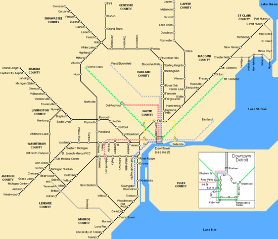 | ||
Upinottawa Member Username: Upinottawa Post Number: 1067 Registered: 09-2005 |
Hudkina, I love your proposal but do we have to trade away Point Pelee to get a system like this? Think of the flying squirrels....  | ||
Professorscott Member Username: Professorscott Post Number: 1754 Registered: 12-2006 |
Hudinka, I'd add a feeder bus Pontiac - Utica - Chesterfield and maybe also Novi - Royal Oak - Roseville. There's a need in the northern burbs to go E-W, but there isn't a rail corridor available. By the way, the Regional Transit Plan includes, I believe, four commuter rail lines. So part of this is going to come to pass. | ||
Hudkina Member Username: Hudkina Post Number: 322 Registered: 12-2004 |
Those would be the only two feeder routes that aren't serviced directly by SMART/DDOT (or whatever the consolidated service would be called), and that's why I added them. Some of the major routes (e.g. Big Beaver, Telegraph, Hall Rd, etc.) would be served by BRT, but I didn't include any of the bus routes on the map because they would be run by a separate transit branch. Not to mention they would clutter up the map even more than it is. Btw, I actually originally had Point Pelee on there, but it looked strange so I just took it out. The map is distorted anyway. | ||
Professorscott Member Username: Professorscott Post Number: 1756 Registered: 12-2006 |
Most good transit maps are, as you put it, distorted, since the purpose is not to show precise geography but to show connections. I've seen bajillions of them, and this one is quite good, and thanks for making it. If the first couple of commuter routes prove successful, you can bet there will be public pressure to add more. The hardest part then, as it is now, will be negotiating usage right with the freight railway companies. The corridors are mostly wide enough to add a second track, but that costs beaucoup dollars. | ||
Hudkina Member Username: Hudkina Post Number: 323 Registered: 12-2004 |
Keep in mind that some of these ROWs are either "dormant" or "extinct". In fact some of them currently have newer developments that sit on the old ROW. One example would be the Lapeer route north of Utica. It connects to Rochester, Goodison (Oakland TWP), Lake Orion, Oxford, Metamora, and Lapeer. However, the railroad doesn't even exist anymore. All that's left is the "rails to trails" pathway. I'm not sure who owns the ROW, or if it even exists anymore. All I know is that at one point there used to be a railroad there. In other words, a lot of this is fantasy, but I guess with enough money and determination, these former railroads could be used again... |