Mortalman Member Username: Mortalman Post Number: 58 Registered: 03-2007 |
Is there anyone out there that has memory of a stream that ran east and west on Davison Ave. E. at Jos Campau? I believe it goes back to the mid-1920's and before. Any memories, stories, vignettes, maps, surveys of this waterway would be appreciated. | ||
Jgavrile Member Username: Jgavrile Post Number: 177 Registered: 09-2005 |
I remember my Dad telling me about it, but that is all I know | ||
Mikeg Member Username: Mikeg Post Number: 1732 Registered: 12-2005 |
From the "1904 Wayne County Atlas", it appears that the northern branch of a watercourse labeled "Holbrook Ave. Ditch" crossed Jos Campau at Carpenter, just south of Davison. 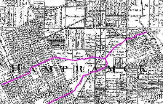 The northern and southern branches of this ditch merged near Forest Lawn Cemetery and then flowed northeastward where it was joined by the "Greenfield and Hamtramck Ditch" at Van Dyke Ave. The combined flows from these ditches emptied into Conners Creek at a point south of Mt. Olivet Cemetery. Here is a high resolution PDF image of the 1904 Hamtramck Twp. map. | ||
Stinger4me Member Username: Stinger4me Post Number: 243 Registered: 08-2007 |
Sometime in the very early 50's there were several bridges in Mt. Olivet Cemetery. The area was later leveled and the old bridge rails removed. I know there was a Conner Creek in the area. | ||
Hamtragedy Member Username: Hamtragedy Post Number: 255 Registered: 10-2007 |
An 1860's map hangs in Hamtramck City Hall. Refers to it as the Carpenter Ditch. Also notable on the City Hall map is the island at the southern end of Hamtramck. Most of know it as Belle Isle. The island is in four parcels, two of which are owned by the Campau family. The other two escape me. Anyone?? |