Fareastsider Member Username: Fareastsider Post Number: 895 Registered: 08-2006 |
Here is one of my favorite images of Detroit. I have a big interest in the development and building of the outlying areas of the city of Detroit. This image is from VMC and shows looking down a recently improved alley in 1939. 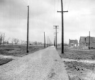 http://dlxs.lib.wayne.edu/cgi/i/image/image-idx?rgn1=vmc_ti;op2=And;rgn2=vmc_ti;med=1;c=vmc;back=back1211920005;q1=alley;chaperone=S-VMC-X-11954-UND-1%2011954_1;evl=full-image;chaperone=S-VMC-X-11954-UND-1%2011954_1;quality=3;view=entry;subview=detail;cc=vmc;entryid=x-11954-und-1;viewid=11954_1;start=1;resnum=9 The interesting part is that there are very few homes in the image at all. As recently as 1939 many parts of the outlying areas of the city of Detroit were largely open like this. I realize that there is very little to work off of from this image but I sure would like to know exactly where it is. From what I can tell it appears to be in one of the more squared off areas of the city, probably the west side. You can tell that the alley you are looking down is running parallel to a street off of to the left. This alley appears to be backing the lots on the main road. The neighborhood streets are running in the opposite direction as you can tell by the houses in the image. It even appears that there is an alley crossing in the foreground. So this alley must run parallel to a mile road or a half mile road like Puritan or Tireman. Here is an example of the type of layout I am talking about. Imagine you are standing in the alley behind 7 mile in this image looking east to get an idea of possible locations. http://s141.photobucket.com/albums/r50/fareastsider/?action=view¤t=7Schaefer-1.jpg In the image you are looking East Schaefer is running left to right at the bottom and Seven Mile is on the left going up and down. It would be like standing where the alleys cross behind Seven Mile Road for example. Anyone think they have some more clues to pinpoint the location of this photo | ||
Ray1936 Member Username: Ray1936 Post Number: 3188 Registered: 01-2005 |
Bad link, but if you cut and paste the whole url it will come up properly. | ||
Jcole Member Username: Jcole Post Number: 1248 Registered: 04-2005 |
That could be the far east side around 7 and Kelly from the way it's laid out. I know a lot of the houses were built in the early 40s | ||
Fareastsider Member Username: Fareastsider Post Number: 896 Registered: 08-2006 |
The semi colon seems to stop the link for some reason and I dont know how to shorten the link. So here is a link to the same image from a photobucket URL. http://s141.photobucket.com/al bums/r50/fareastsider/?action= view¤t=ALLEY.jpg | ||
Craig Member Username: Craig Post Number: 810 Registered: 02-2007 |
Why do you think that this is an alley? Narrow, and with utility poles on either side, I agree, but the layout is wrong. Alleys on the west side (and everywhere?) run parallel, not perpendicular to the front/back of homes. I'll admit that this looks like an alley, but the few standing homes contradict this. | ||
Aoife Member Username: Aoife Post Number: 56 Registered: 04-2007 |
It is an alley- it was a WPA project. I actually have the article that corresponds to this images in my notes at home- I can post the definitive location tonight if you would like. There were hundreds of alleys like this paved by the WPA in areas that were not fully developed. If I recall, the photo was taken to illustrate the fact that these sorts of projects were going on in areas that might not necessarily need them, but since street paving and alley projects were relatively inexpensive to the city (since they only had to pay for supplies), they were the most popular types of projects to approve. | ||
Craig Member Username: Craig Post Number: 811 Registered: 02-2007 |
Aoife - please, post the details. I still cannot get my head around an alley that runs the wrong way; not the eighth wonder of the world, but an interesting oddity. | ||
Fareastsider Member Username: Fareastsider Post Number: 897 Registered: 08-2006 |
Craig first of all the photo description is one of an alley and second of all I described in my first post how the alley that we are looking down must be an alley for the road running in the same direction on the left side of the picture. A main road I am assuming. That is why the houses face another direction as they are on streets that run off of that main road. The alley in the pic is behind the road on the left. Imagine we are looking west behind a main road like seven mile. The roads the houses are on are running north south for example. Aoife of course I would like to know the location! These projects must explain why during the 30s and 40s there were a lot of subdivisions that had noticable improvements but no houses. During the twenties there were probably so many subdivisions platted that were not built until the post war period. Many subs from this time sat idle until the post war period and many closer to the city had improvements by the WPA. Further out from the city there are a number of subs platted that you could not see anymore as at best they had a dirt road put in and sat as they were never built. Some sit to this day only shown on plat maps. Others were built and some were replated. A friend of mine lives on a street that dead ends after only 200 feet but the road actually continues for another 1/2 mile. There is even a cross street that doesnt exist anymore but it was platted. On old aerials the best it looked was basically dirt paths for roads. Today most of his sub is a forest. . . but a developer does own the rest of the lots. Today it seems like this is all happening again as many subdivisions sit with roads and lights but little to no houses! | ||
Craig Member Username: Craig Post Number: 812 Registered: 02-2007 |
"Mainroad"?! Aha! Alley behind a commercial strip? Got it. Makes plenty of sense now. If this is so, then this picture really was taken in the sticks. I would have expected the main streets to be laid out and paved long before houses started to go up (but then how would I know). | ||
Aoife Member Username: Aoife Post Number: 57 Registered: 04-2007 |
Good thing I am not organized- I had it in a file at my desk! The article from the Detroit News (April 9, 1939) does not give an exact location in the caption, but talks of a strip of alleys Between McNichols and Seven Mile behind Lauder and Marlowe Avenues that were paved while the actual streets were still unpaved. Apparently residents were using the alleys as go-throughs because it was easier than driving on the dirt roads. The gist of the article talks of the battle between the WPA and real estate development companies. It was a standard policy that the WPA would not pave roads on new housing developments if it would benefit privately owned building companies. It was a common practice with builders of subdivisions at that time where they would buy land and build housing units on them with the the intention that a federal project could do the improvements, such as link them up to the city water/sewer and pave the roads (thereby not having to pay for it themselves, as they would have had to prior to the WPA). This is why you sometimes find WPA sidewalks on parts of streets that never had houses built on them, or alleys that seemingly go nowhere. I hope this helps..... | ||
Jcole Member Username: Jcole Post Number: 1257 Registered: 04-2005 |
This looks like what you're talking about regarding the way the alley is laid out in that area. The yellow highlight is the alleyway 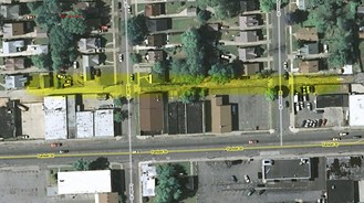 | ||
Jgavrile Member Username: Jgavrile Post Number: 106 Registered: 09-2005 |
yea, these would be the alleys servicing the commercial buildings along a main street. Makes sense now. | ||
Jcole Member Username: Jcole Post Number: 1261 Registered: 04-2005 |
That is the alley behind Fenkell and the two cross streets are Lauder and Marlowe, so it's the area in the photo posted by fareastsider and cited by Aoife. If you google Marlowe and 7 Mile Rd. and use satellite view, you can see another example. | ||
Fareastsider Member Username: Fareastsider Post Number: 899 Registered: 08-2006 |
Thanks a lot Aoife! Why did you have that particular article? did you look it up after seeing the image before? I really didnt think this one would be located. Now I got to go get a present day picture. I am amazed that that part of town so deep into the city was that rural that recently. Aoife got any other similar images of this era or WPA work projects? This era of the cities history is very interesting to me. Jcole what makes you think its Fenkell and not Seven Mile? By using maps.live.com I can not find the houses in the photo. I sure would like to pin point this location then take a photo of it today. (Message edited by fareastsider on May 28, 2008) (Message edited by fareastsider on May 28, 2008) | ||
Rel Member Username: Rel Post Number: 729 Registered: 02-2008 |
I love detroityes.com! | ||
Reddog289 Member Username: Reddog289 Post Number: 320 Registered: 08-2007 |
reminds me of an "alley" in Garden City. looks like the houses there might have been built the same time. | ||
Aoife Member Username: Aoife Post Number: 58 Registered: 04-2007 |
No problem, Fareastsider! I had the article because I wrote one of those Arcadia books on the WPA in Detroit- if you are interested in that era, next time you are at the library see if it is around. The chapter on the arts projects has some really fantastic pictures in it. Here are some more links to images in the VMC: http://dlxs.lib.wayne.edu/cgi/ i/image/image-idx?q1=works+pro gress&rgn1=vmc_all&op2=And&q2= &rgn2=vmc_ti&type=boolean&c=vm c&view=thumbnail http://dlxs.lib.wayne.edu/cgi/ i/image/image-idx?q1=works+adm inistration&rgn1=vmc_all&op2=A nd&q2=&rgn2=vmc_ti&type=boolea n&c=vmc&view=thumbnail http://dlxs.lib.wayne.edu/cgi/ i/image/image-idx?q1=WPA&rgn1= vmc_all&op2=And&q2=&rgn2=vmc_t i&type=boolean&c=vmc&view=thum bnail |