Gmich99 Member Username: Gmich99 Post Number: 255 Registered: 11-2005 |
Does anyone have any information regarding where the canal originally terminates and whether that section still contains water. Any other comments and insight would be appreciated. | ||
Johnlodge Member Username: Johnlodge Post Number: 4105 Registered: 10-2003 |
There was a great thread on this posted here some time back. Not sure if it still exists, you might try searching around a bit. It had maps and photos and everything. | ||
Professorscott Member Username: Professorscott Post Number: 945 Registered: 12-2006 |
If you follow Canal Road between Utica and Mt. Clemens you are driving next to where the canal was. There is no part of it in that area that still has a ditch, so far as I have ever been able to tell. At the east end of that road is a park at the entrance to which is a historical marker that has a bit more information. | ||
Mdoyle Member Username: Mdoyle Post Number: 284 Registered: 10-2006 |
Between Hayes and Garfield on Canal there is still a really deep ditch beside the road. It used to still exist all the way to Clinton River Road but in the past 5-10 years Kroger expanded and covered it over and the new Clinton Macomb Library covered another large section. | ||
Jimaz Member Username: Jimaz Post Number: 4015 Registered: 12-2005 |
There's a section north of Utica that has water. At one point it drains down a steep sluice into the Clinton river. It's a nice secluded hike back there. There are a few deer near there. | ||
Gotdetroit Member Username: Gotdetroit Post Number: 103 Registered: 12-2005 |
http://shelbyhistory.tripod.co m/shelbytownshiphistoricalcomm ittee/id18.html | ||
Jimaz Member Username: Jimaz Post Number: 4016 Registered: 12-2005 |
Here's a Google Earth clip of the part north of Utica. 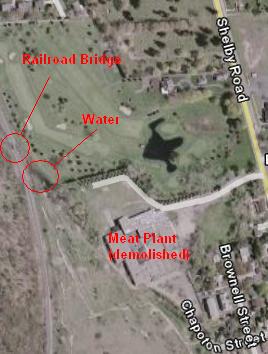 You can park in the demolished meat packing plant's parking lot at the end of Chapoton Street. Oddly, there are no "no parking" or "no trespassing" signs. You can hike west then north around the plant's perimeter fence. The fence is broken in two places back there so you can actually get in to that end of the canal ditch. (Watch your step on the unlevel ground.) There's more water a bit north of there that goes under the railroad bridge. The canal continues beyond but I don't recall how far. This clip is at 42°38'02"N 83°02'27"W. It really is a pleasant hike though. (Message edited by Jimaz on December 10, 2007) | ||
Jimaz Member Username: Jimaz Post Number: 4017 Registered: 12-2005 |
There's a decent homemade footbridge over the canal southwest of the Utica High School property. The footbridge is at 42°38'21"N83°2'46"W. The canal trail merges with the main River Bends Park trail about seventy-five feet farther. 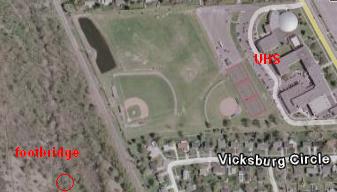 It continues northward under 22 Mile Rd. near River Bends Park. 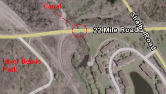 (Message edited by Jimaz on December 10, 2007) | ||
Raptor56 Member Username: Raptor56 Post Number: 209 Registered: 05-2007 |
You can view part of the canal, as well as a historical marker at Yates Roadside Park, across from Yates Cider mill on Avon and Dequinder. http://www.rochesterhills.org/ reference_desk/uploads/bloomer yatesservices.pdf http://www.michmarkers.com/sta rtup.asp?startpage=S0096.htm ARticle about a canal Lock being found a couple years ago: http://www.macombdaily.com/sto ries/092504/loc_canal001.shtml Canal Park http://www.ctwphc.org/article. html?id=3 http://shelbyhistory.tripod.co m/id19.html number 4 and 5 in the list: http://www.mcgi.state.mi.us/hs o/hsmatchname.asp?hsn=clemens Canal Park: http://www.clintontownship.com /parks/parkcanal.htm | ||
Gistok Member Username: Gistok Post Number: 5872 Registered: 08-2004 |
Thanks for the pic Jimaz... how ironic the name of the street there is Chapoton... the same name as that used for a huge drain in SCS that empties into the huge Chapoton Pumping Station at 9 Mile & Jefferson. Of course this is just coincidental. | ||
Mikeg Member Username: Mikeg Post Number: 1313 Registered: 12-2005 |
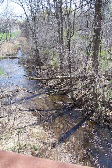 A view of the old canal looking south from the pedestrian bridge alongside 22 Mile Road (at the circle labeled "Canal" in Jimaz's last aerial image). An easier way to explore the old canal is to park in the River Bends Park parking lot and walk to the trail that parallels the old canal (shown in red, below). The circle shows the location of another homemade footbridge over the canal which allows you to climb up the railroad embankment. 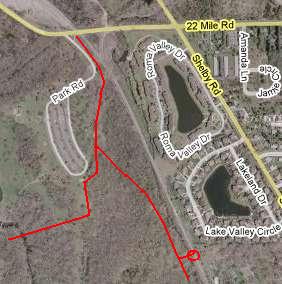 Aerial photos showing the parking lot at River Bends Park and the trails. The red circle shows the approximate location of the homemade footbridge. 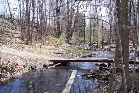 Footbridge over the old canal, with the railroad embankment on the left. 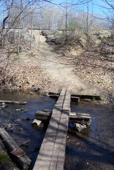 Footbridge with railroad embankment in the background. The canal can also be explored within the Holland Ponds park, which is located on the west side of Ryan Road, just north of the 22 Mile Road intersection. 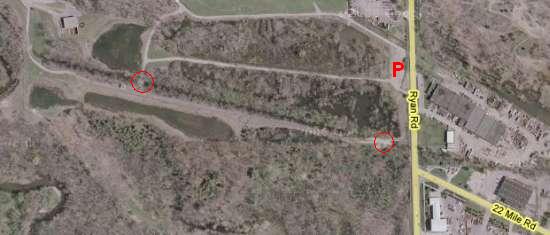 This aerial view shows the parking lot (P) and the red circles represent crossing points over the old canal. The canal sections in these two parks still contain water, which flows gently to the east and southeast. The reason for that is that when the canal builders ran out of money, it was only completed as far as Yates Cider Mill where there was a sluice gate intended to provided the water to operate the canal locks. The enterprising operators of the mill at Auburn Road in Utica decided to turn the section of abandoned canal between the sluice gate and their mill into a mill race which would deliver water to turn their water wheel. The mill and water wheel are long gone, but the water still flows in the old canal bed towards Utica. | ||
Bsu Member Username: Bsu Post Number: 115 Registered: 10-2003 |
Behind the VanHoosen farm, in front of the new Stony Creek High School, and in the park across the street from Yates cider mill you can still see concrete canal structures. The structures appear to be locks and bridges. The structure behind the actual farm house looks like where the canal went over the river, just like it used to do in the park across from Yates cider mill. The sections behind the farm and in front of the school are hidden behind trees, and a little more difficult to locate. | ||
Ddaydave Member Username: Ddaydave Post Number: 512 Registered: 04-2005 |
ahhhh boyhood memories I used to play along that canal in utica all thru school we would ride our dirt bikes all the way from were it drains in the clinton river to yates cider mill .. the old timers in the area told me it used to dry up in the summer but it never did when I was a kid ..I once found a 1910 dime on the banks of the canal me and my buddies mostly played around the canal behind Lincoln meadows subdivision | ||
Jimaz Member Username: Jimaz Post Number: 4020 Registered: 12-2005 |
Gistok, you're welcome. Sorry I don't have more history of those street names at hand. I do have a copy of SUMMER along the CLINTON, A History of the Clinton River Parks, by Wally Doebler. quote:There are also a few pages about Carpathia Park here. (Message edited by Jimaz on December 10, 2007) | ||
Bigb23 Member Username: Bigb23 Post Number: 97 Registered: 11-2007 |
Was the Spillway from Lake St. Clair any part of that project, or was that from a later date? I used to live there on Jefferson at one time. It sure looks like a barge canal from the early 1800's. | ||
Bibs Member Username: Bibs Post Number: 713 Registered: 10-2003 |
The spillway from the Clinton River to Lake St Clair was constructed in 1960's I believe to alleviate flooding. A gate for the canal was recently discovered at Canal Rd and Clinton River Rd. Shelby Twp Historical Committee: The aqueduct remains are still visible at Yates Cider Mill, and the canals beginning at the old townsite of Frederick at Clinton River and Canal Roads has been deeded to Clinton Township and will become a park. | ||
Gmich99 Member Username: Gmich99 Post Number: 256 Registered: 11-2005 |
Thanks to all of you for the helpful insights. | ||
Raptor56 Member Username: Raptor56 Post Number: 215 Registered: 05-2007 |
Lake St Clair Spillway is used to alleviate the large cyclical St Clair Floods. I've heard many times from my grandpa, the story of how he had to sandbag his property during the big floods. On a side note, you can find some decent Salmon fishing along the spillway weir during the spawning season. | ||
Chitaku Member Username: Chitaku Post Number: 1731 Registered: 03-2006 |
Clinton Township has a park dedicated to the history of the canal at Canal and Clinton River rd. | ||
Mikeg Member Username: Mikeg Post Number: 1317 Registered: 12-2005 |
Actually the Spillway was designed to alleviate flooding along the curvy section of the Clinton River between Shadyside Park in Mt. Clemens and the mouth of the river on Lake St. Clair. The spillway weir is set high enough to keep regular flows of water proceeding down to the mouth of the river. However, when the river's water level rises over the top of the weir, the excess flow proceeds directly down the spillway to Lake St. Clair. The spillway was constructed sometime around 1950, as evidenced by these two DTE aerial photos dated May 3, 1949 and April 16, 1952. 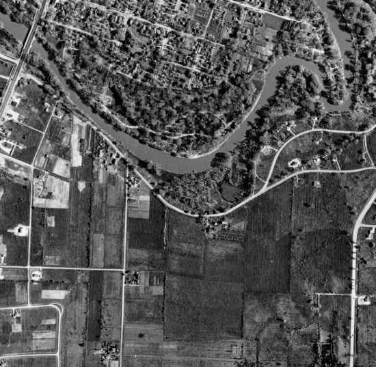 May 3, 1949 aerial 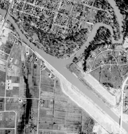 April 16, 1952 aerial |