 
Johnlodge
Member
Username: Johnlodge
Post Number: 3507
Registered: 10-2003
| | Posted on Friday, November 09, 2007 - 12:53 pm: |    |
Here's something I made for fun. It's a Woodward light rail map. You guys are going to tear it to shreds, but I'm expecting that.
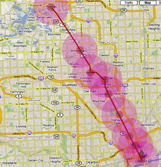
The green dots are the main stations. There would be more I'm sure. The small red cirlces are a 1/2 mile radius, which from what I can find, is about how far people want to walk to transit. The larger pink circles are a 2 mile radius, which seems to be how far people want to drive to park and ride transit. I'm sure it is horribly flawed. Enjoy making fun of it. |
Gazhekwe
Member
Username: Gazhekwe
Post Number: 971
Registered: 08-2007
| | Posted on Friday, November 09, 2007 - 12:55 pm: | |
Are there stations in between the main stations?
(Message edited by gazhekwe on November 09, 2007) |
Johnlodge
Member
Username: Johnlodge
Post Number: 3508
Registered: 10-2003
| | Posted on Friday, November 09, 2007 - 12:57 pm: | |
I was thinking so, I just didn't put them all in. I can add them if there are suggestions? |
Nainrouge
Member
Username: Nainrouge
Post Number: 328
Registered: 05-2006
| | Posted on Friday, November 09, 2007 - 12:59 pm: | |
Hows about a park-and-ride lot stop closer to the Davison and another at 696? |
Gazhekwe
Member
Username: Gazhekwe
Post Number: 972
Registered: 08-2007
| | Posted on Friday, November 09, 2007 - 12:59 pm: | |
I like it. Now I need a Ten Mile connector and station. |
Fury13
Member
Username: Fury13
Post Number: 3128
Registered: 10-2003
| | Posted on Friday, November 09, 2007 - 1:00 pm: | |
Looks pretty good. I'd put in a stop in front of Cranbrook and more in the city of Detroit. Logical Detroit stops to me would be Jefferson, Grand Circus, Canfield (to cover lower Midtown and WSU), Ferry (to cover the Cultural Center), Grand Blvd., Holbrook, Manchester (Highland Park), Six Mile, and State Fair. |
Johnlodge
Member
Username: Johnlodge
Post Number: 3509
Registered: 10-2003
| | Posted on Friday, November 09, 2007 - 1:03 pm: | |
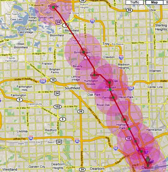
For Nainrouge, I have turned Schostak's failed Gateway development into a park and ride and added a station at the Davison.
|
Dougw
Member
Username: Dougw
Post Number: 1980
Registered: 11-2003
| | Posted on Friday, November 09, 2007 - 1:03 pm: | |
Your plan works for me. ;) I'd realistically like to see a *few* more stations but not a lot more. For those who need special stops every 1/2 mile, they can take the bus. A light rail line shouldn't have too many stops.
I'm not sure if it would make sense to have two different "types" of stations. |
Detroitrise
Member
Username: Detroitrise
Post Number: 552
Registered: 09-2007
| | Posted on Friday, November 09, 2007 - 1:04 pm: | |
You forgot a New Center and DMC Stop (Grand BLVD. and Mack)
(Message edited by DetroitRise on November 09, 2007) |
Johnlodge
Member
Username: Johnlodge
Post Number: 3510
Registered: 10-2003
| | Posted on Friday, November 09, 2007 - 1:05 pm: | |
No they aren't different types of stations, by main stations I just meant the ones I thought were most important. |
Dougw
Member
Username: Dougw
Post Number: 1981
Registered: 11-2003
| | Posted on Friday, November 09, 2007 - 1:05 pm: | |
Probably you'd need one more stop somewhere between the CBD and the Wayne State, at least. |
Detroitrise
Member
Username: Detroitrise
Post Number: 553
Registered: 09-2007
| | Posted on Friday, November 09, 2007 - 1:07 pm: | |
^^^That's the DMC/Brush Park stop.
(Message edited by DetroitRise on November 09, 2007) |
Johnlodge
Member
Username: Johnlodge
Post Number: 3511
Registered: 10-2003
| | Posted on Friday, November 09, 2007 - 1:12 pm: | |
DMC stop added and I moved my misplaced New Center stop closer to GB.
|
Rsa
Member
Username: Rsa
Post Number: 1333
Registered: 10-2003
| | Posted on Friday, November 09, 2007 - 1:16 pm: | |
i think it's pretty good. probably the first line that's be put in if we ever get any type of light rail mass transit.
i think it's good the way it is. i don't think more stations should be added. if you start adding more stations it lengthens the ride and reduces the likelihood that people would use it. plus, a lot of stop and go is slightly annoying. perhaps a second phase can do "local" branches that might "feed" this line?
my own personal opinion on once you get to new center is to use more of a loop format. not have it be a straight shot down woodward, but loop it on either side to service as many locations as you can. have stops at things like henry ford hospital, woodbridge, the medical center, brush park, masonic temple, motor city casino, eastern market, rivertown/front, joe louis, etc. you could have connectors at certain points, like warren, mack and maybe the riverfront. i think this solution would also help alleviate some of the planning nightmares associated with running it thru downtown while servicing a lot of the neighborhoods and destinations.
[just my thoughts, not meant as a criticism.] |
Johnlodge
Member
Username: Johnlodge
Post Number: 3512
Registered: 10-2003
| | Posted on Friday, November 09, 2007 - 1:18 pm: | |
Added Fury's Cranbrook stop. Now the students at CCS can go visit their grad school friends.
|
Iheartthed
Member
Username: Iheartthed
Post Number: 2137
Registered: 04-2006
| | Posted on Friday, November 09, 2007 - 1:44 pm: | |
I think anything past Ferndale should be served by commuter rail. For a commuter rail line, I would use the same template but remove all of the stops within the city except 8 Mile/State Fairgrounds, Highland Park, New Center and Downtown.
For a light rail/subway system, I would prefer to see stops every half mile, thus there would be about 18 stops on the line if it went from Jefferson to 9 Mile. There would also ideally be a parallel express line that stopped roughly every 1.5 to 2 miles and at tranfer points to the local line. There would be roughly 5 stops on the express between downtown and 9 Mile. This would be to speed up the commutes of people towards the end of the line, attract residential development to all parts of the line, and encourage growth of the CBD as a business district again. |
Waz
Member
Username: Waz
Post Number: 230
Registered: 11-2006
| | Posted on Friday, November 09, 2007 - 1:49 pm: | |
Since we're dreaming, how about a spur into Hamtramck from the Highland Park stop and re-joining back at the WSU stop, or possibly even continuing from Hamtramck down to Lafayette Park then cutting back to downtown? |
Johnlodge
Member
Username: Johnlodge
Post Number: 3515
Registered: 10-2003
| | Posted on Friday, November 09, 2007 - 1:50 pm: | |
I did have a spur called the Yuppie Express that went between Birmingham and Somerset, but I decided to keep this one as simple as possible.  |
Wirt
Member
Username: Wirt
Post Number: 71
Registered: 12-2005
| | Posted on Friday, November 09, 2007 - 1:57 pm: | |
I like the fact that it remains on Woodward as it goes through Birmingham rather than following the rail right of way. |
Johnlodge
Member
Username: Johnlodge
Post Number: 3517
Registered: 10-2003
| | Posted on Friday, November 09, 2007 - 1:59 pm: | |
Who knows, Big Rock Chophouse could turn back into a rail station. Wait for the train, AND have a nice steak. |
Hudkina
Member
Username: Hudkina
Post Number: 73
Registered: 12-2004
| | Posted on Friday, November 09, 2007 - 3:10 pm: | |
Here's a map I made awhile ago showing both light rail and commuter rail:
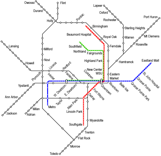
The light rail has stations every half mile or so. The only portion that doesn't is the length between Inkster and Metro Airport, which currently doesn't have the density to support light rail. The commuter rail stations are generally about 2 or 3 miles apart, but in some instances they are further apart.
I tried to make the map similar to how you see other cities transit system maps, so it isn't necessarily to geographic scale.
The Red Line runs along Woodward from Big Beaver Rd in Birmingham to Downtown. It veers along Sherman Dr/Washington Ave through downtown Royal Oak. South of Downtown it runs along Fort St until it reaches Pennsylvania Rd in Southgate.
The Blue Line runs along Merriman Rd/Michigan Ave from Metro Airport to Downtown. From there it runs along E Jefferson/Alter Rd/Mack Ave/Vernier Rd until it reaches Eastland Mall in Highland Park.
The Green Line runs along the tracks of the Blue Line and Red Line from West Dearborn until 8 Mile Rd. It then veers off along 8 Mile Rd until it reaches Northland Mall. From there it runs parallel to the Lodge Freeway until it reaches I-696.
As far as the commuter rail is concerned it runs mainly along current and former railroad lines. In some cases the old rail line is nothing more than a trail, while in others it is a busy freight route. There are eight major routes. Seven of those routes start in Downtown Detroit and radiate out towards major cities on the outskirts of the Metro. Those cities are Port Huron, Lapeer, Owosso, Lansing, Jackson, Adrian, and Toledo. The eighth line runs from Flint in the north to Toledo in the south.
There are three major transit centers. One in West Dearborn near Michigan Ave and Oakwood Blvd. It is adjacent to Greenfield Village, and is a connector between the Green/Blue Line and the commuter rail line.
The second one is in Downtown Royal Oak near 11 Mile Rd and Sherman Dr. It is a connector between the Red Line and the commuter rail line.
The third and largest one is in Downtown Detroit on the land where Cobo Arena currently sits. It connects all three light rail lines as well as seven of the eight commuter rail lines. It has direct access to Cobo Hall as well as a new People Mover station. It also houses a large retail promenade and a hotel tower. |
Rb336
Member
Username: Rb336
Post Number: 3481
Registered: 02-2007
| | Posted on Friday, November 09, 2007 - 3:21 pm: | |
one near cranbrook would be nice |
Danindc
Member
Username: Danindc
Post Number: 3721
Registered: 10-2003
| | Posted on Friday, November 09, 2007 - 3:21 pm: | |
What software did you use to make the map, Hudkina? |
Hudkina
Member
Username: Hudkina
Post Number: 74
Registered: 12-2004
| | Posted on Friday, November 09, 2007 - 3:24 pm: | |
As far as individual light rail stations, here is a list from Downtown to Birmingham:
1. Downtown Transit Center
2. Campus Martius
3. Grand Circus Park
4. Temple St (Brush Park/Cass Park)
5. Mack Ave (Detroit Medical Center)
6. Warren Ave (Wayne State University)
7. Harper Ave (Techtown/Medbury Park)
8. Grand Blvd (New Center)
9. Seward St (New Center Commons/North End)
10. Holbrook St (North End)
11. Chicago Blvd (Boston-Edison/Arden Park)
12. Woodland St (Highland Park)
13. Glendale St (Highland Park)
14. Manchester St (Highland Park/Model T Plaza)
15. McNichols Rd (Palmer Park Apartments)
16. Nevada St (Palmer Park)
17. 7 Mile Rd (Palmer Woods)
18. State Fair Ave (State Fairgrounds/Woodlawn Cemetary)
19. 8 Mile Rd (Gateway Park)
20. Marshall St (Ferndale)
21. 9 Mile Rd (Downtown Ferndale)
22. Woodward Heights Blvd (Pleasant Ridge)
23. I-696 (Detroit Zoo)
24. Lincoln Ave (Royal Oak/OCC)
25. Royal Oak Transit Center (Downtown Royal Oak)
26. Catalpa Dr (Royal Oak)
27. 12 Mile Rd (Berkley/Roseland Park Cemetary)
28. Webster Rd (Royal Oak)
29. Coolidge Hwy (Beaumont Hospital)
30. Normandy Rd (Royal Oak)
31. 14 Mile Rd (Birmingham)
32. Adams Rd (Birmingham)
33. Maple Rd (Downtown Birmingham)
34. Oak Blvd (Birmingham)
35. Big Beaver Rd (Birmingham) |
Hudkina
Member
Username: Hudkina
Post Number: 75
Registered: 12-2004
| | Posted on Friday, November 09, 2007 - 3:26 pm: | |
I used Microsoft Paint to make the actual routes and then used Photoshop to put in the labels. |
Iheartthed
Member
Username: Iheartthed
Post Number: 2142
Registered: 04-2006
| | Posted on Friday, November 09, 2007 - 3:30 pm: | |
>Hudkina
I like that one. The only thing is that it's not serving a large chunk of the city's population along the Grand River corridor.
Which brings me to another thought. If/when the transit line(s) are eventually built, should they be built out from the almost abandoned sections of the city?
I need to see a population distribution map to verify, but I think Detroit is unique in that the population is heavier away from the central areas of the city. So building the transit lines from inside to out will encourage redevelopment of these areas that were abandoned? While not severely disrupting the flow of the areas that are pretty well established now.
ETA: Hudkina's map reminds me of the DC subway maps...
(Message edited by iheartthed on November 09, 2007) |
Livernoisyard
Member
Username: Livernoisyard
Post Number: 4567
Registered: 10-2004
| | Posted on Friday, November 09, 2007 - 3:30 pm: | |
JL: You might find this awfully hard to believe, but there's a bus route essentially going along the same route as yours. Yep! No shit! Again, a dollar short and many decades behind...
Now that Pontiac is beginning to take over as the bona fide downtown of the region, maybe those in Pontiac could be tapped to pay for most of your pipe dream. Maybe, we could also stick the SMART bus-route costs more onto them also in the interim. Whad'ya think? |
Johnlodge
Member
Username: Johnlodge
Post Number: 3525
Registered: 10-2003
| | Posted on Friday, November 09, 2007 - 3:33 pm: | |
I knew I could count on you, LY. Surprised it took so long for you to show up! |
Livernoisyard
Member
Username: Livernoisyard
Post Number: 4568
Registered: 10-2004
| | Posted on Friday, November 09, 2007 - 3:39 pm: | |
I might go for some light transit if a special five-miles-off-the-beaten-trai l link were incorporated so I could hop on nearby. I wouldn't quite want door-to-door service as I don't mind walking a few houses away... |
Hudkina
Member
Username: Hudkina
Post Number: 76
Registered: 12-2004
| | Posted on Friday, November 09, 2007 - 3:40 pm: | |
I think Grand River and Gratiot are best served by bus routes or possibly BRT. I also think Big Beaver/Metro Pkwy between Birmingham and Metro Beach should be served by BRT and possibly Telegraph Rd between I-696 and Eureka Rd. Another possible BRT line would be along 8 Mile Rd between Northland Mall and Eastland Mall.
I chose the Michigan Ave and Woodward lines because they are both regional backbones. I chose the E Jefferson and Fort St lines because they both run a significant portion of their routes near the River which, hopefully will one day be home to apartment/condo high rises. (planning for the future) The Green Line is basically just a spur that runs off to the office corridor in Southfield.
Putting light rail along Gratiot or Grand River probably won't spur as much development as it would putting it along Michigan, Woodward, Fort, and E Jefferson.
(Message edited by hudkina on November 09, 2007) |