Abracadabra Member Username: Abracadabra Post Number: 125 Registered: 04-2007 |
I'm sure we can all agree that in our current stage of urban and suburban sprawl, Hines Park is a welcomed ban of green space and a nice connector to Dearborn for those Ford people living in Livonia and Northville. Nevermind, of course, that next to the industry at it's mouth, the Rouge has suffered more from it's existence than just about anything. Hines Park is shown in it's signage to be "Historic". When was it built? Does anybody have any pictures or anything from it's construction? Any old maps showing it's pull off parks from now and from the past? And what, if anything, was plowed down to create it? | ||
Alsodave Member Username: Alsodave Post Number: 802 Registered: 10-2003 |
http://www.waynecounty.com/dps _roads/history/hines.htm | ||
Alsodave Member Username: Alsodave Post Number: 803 Registered: 10-2003 |
This one, too: http://www.waynecounty.com/par ks/hines.htm Some historical info and photos in the various links. | ||
Zephyrprocess Member Username: Zephyrprocess Post Number: 505 Registered: 08-2006 |
quote:The park is the river's flood plain, which is why "Hines Drive is closed due to flooding" is the local traffic report equivalent to "sun rose in the east." So there was very little development, save for a number of mills powered by the river flow. In the 1920s Henry Ford did run something of a "cottage industry" experiment (I believe it was called the "Village Industry" project) in which he sited small manufacturing facilities in former mills along the river, in the effort to slow urbanization. Nankin Mills is the most well preserved instance. See http://www.detroit1701.org/Nan kin%20Mills.html | ||
Brougham Member Username: Brougham Post Number: 51 Registered: 01-2007 |
I recently snapped a couple pics of bridge plaques along Hines. They are from the area between Newburg Lake and Wilcox rd. It seems a lot of work was done in the 1930's. 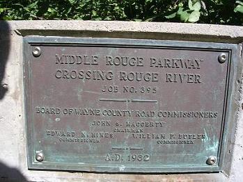 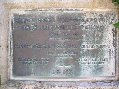 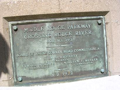 | ||
Catman_dude Member Username: Catman_dude Post Number: 237 Registered: 03-2006 |
I've always wondered why the mill didn't have running water by/under it, otherwise it would be a true mill. But sometime during the late 1930s, the mill was remodeled and the river dammed up. So now there is standing water up to the mill and the other side of the parking lot. Some years ago, my brother got a big, thick, hard cover Ford history book as a gift for Ford employees and one of the pictures shows what looks to be a lake behind the mill. This wasn't in the direction of Newburg Lake but right where the ballfields would be! We knew that Hines Park floods when it rained but man, the level it appeared to be in that book looks as if the water was 10-15 feet deep! | ||
Novine Member Username: Novine Post Number: 175 Registered: 07-2007 |
http://www.nankinmills.org/Hin es%20Drive.htm and http://getoffmyspleen.blogspot .com/ | ||
Abracadabra Member Username: Abracadabra Post Number: 130 Registered: 04-2007 |
Man oh man, you guys rock! I'll spend a couple of days going over this stuff. | ||
Jb3 Member Username: Jb3 Post Number: 257 Registered: 06-2007 |
Excellent post. I am continually amazed/ confounded at how much of our building stock is left unrecognized by the national historic registers. |