 
Focusonthed
Member
Username: Focusonthed
Post Number: 1370
Registered: 02-2006
| | Posted on Monday, October 15, 2007 - 1:18 am: |    |
What's the deal with the big open space at the hypothetical 15 1/2 Mile Road between Dequindre and Schoennher? |
Fareastsider
Member
Username: Fareastsider
Post Number: 628
Registered: 08-2006
| | Posted on Monday, October 15, 2007 - 1:20 am: | |
That would be the Sterling Relief Drain. Sterling Heights or um Sterling Twp used to have a flooding problem.
(Message edited by fareastsider on October 15, 2007) |
Fareastsider
Member
Username: Fareastsider
Post Number: 629
Registered: 08-2006
| | Posted on Monday, October 15, 2007 - 1:25 am: | |
Out in the northern reaches of Lake St. Clair it seems that the platted subdivisions of the 20s never realized the expected demand. There are many subdivision only built a fraction of what they should have been or not at all in some cases. Here are two good examples. My friend has a house in this subdivision but it was only partialy built out still to this day though the roads and lots still exist....many of the unimproved lots owned by a developer. The Saint Clair Countryclub Estates today.
http://maps.google.com/maps?q= Lake+Park+Rd,+Fair+Haven,+MI+4 8023,+USA&sa=X&oi=map&ct=image
You can see the unimproved roads in the woods. and here is the original plat.
http://www.cis.state.mi.us/pla tmaps/dt_image.asp?BCC_SUBINDE X=22721
On the adjacent parcel is a subdivision never completed at all yet all the lots and roads still exist!
http://www.cis.state.mi.us/pla tmaps/dt_image.asp?BCC_SUBINDE X=22714 |
Novine
Member
Username: Novine
Post Number: 173
Registered: 07-2007
| | Posted on Monday, October 15, 2007 - 2:30 am: | |
Re: 14 Mile Road between Evergreen and Southfield, I would guess wetlands and the Rouge River.
http://maps.google.com/maps?f= q&hl=en&geocode=&time=&date=&t type=&q=southfield+mi&ie=UTF8& ll=42.531722,-83.241005&spn=0. 00574,0.01133&t=h&z=17&om=1
The same situation exists in Novi where several "mile" roads stop and start due to wetlands.
13 Mile end and then picks up again as West Road:
http://maps.google.com/maps?f= q&hl=en&geocode=&time=&date=&t type=&q=novi+mi&ie=UTF8&ll=42. 504946,-83.486309&spn=0.045938 ,0.090637&t=h&z=14&om=1
Wixom Road (north-south) ends at 10 Mile and then continues again south of wetlands as Garfield Road.
http://maps.google.com/maps?f= q&hl=en&geocode=&time=&date=&t type=&q=novi+mi&ie=UTF8&ll=42. 456648,-83.532057&spn=0.022987 ,0.045319&t=h&z=15&om=1 |
Hpgrmln
Member
Username: Hpgrmln
Post Number: 218
Registered: 06-2007
| | Posted on Monday, October 15, 2007 - 7:31 am: | |
One oddity is Lonedale Rd. in Auburn Hills. Its on or near OU property.It goes through a field and dead ends. The ultimate road to nowhere. what is the intention of this road? |
Mallory
Member
Username: Mallory
Post Number: 201
Registered: 05-2006
| | Posted on Monday, October 15, 2007 - 9:06 am: | |
I have nothing to add, but did want to send props to Fareastsider for the thread. This is fascinating stuff! Call me a geek. |
Viziondetroit
Member
Username: Viziondetroit
Post Number: 1196
Registered: 11-2003
| | Posted on Monday, October 15, 2007 - 9:22 am: | |
I was routing my way to a meeting and noticed this on the map. Is this an unfinished road in Detroit over I-75?
http://maps.yahoo.com/#mvt=h&g id1=16223579&q1=5700+russell%2 C+detroit%2C+mi&trf=0&lon=-83. 058937&lat=42.37187&mag=1 |
Leland_palmer
Member
Username: Leland_palmer
Post Number: 397
Registered: 08-2004
| | Posted on Monday, October 15, 2007 - 9:46 am: | |
Looks like a rail via-duct. |
Burnsie
Member
Username: Burnsie
Post Number: 1176
Registered: 11-2003
| | Posted on Monday, October 15, 2007 - 10:01 am: | |
The Davison Fwy. was supposed to continue west to meet I-96; that's why the intersection of Davison Ave. and I-96 is set up for Davison to be a freeway (and it's why I-96 has a dogleg curve to meet that spot). (info from the michiganhighways site) |
Catman_dude
Member
Username: Catman_dude
Post Number: 234
Registered: 03-2006
| | Posted on Monday, October 15, 2007 - 11:08 am: | |
In Westland, there are two roads, Farmington Road and Venoy Road, that end at the Rouge River in Hines Park. There used to be bridges over the river that were taken out when Hines Park was established but I don't really know that. In satellite pictures, you can see the outline of Farmington Road on the other side of the river (in the park) which meets up with Hines Drive. Farmington Road continues on the other side of Ann Arbor Trail right in a straight line with the other part of the road. Farmington Road used to cut through the Nankin Mills property?
http://maps.google.com/maps?f= q&hl=en&geocode=&time=&date=&t type=&q=venoy+road,+westland&s ll=42.678255,-82.63931&sspn=0. 006626,0.014291&ie=UTF8&ll=42. 347682,-83.370287&spn=0.006661 ,0.014291&t=h&z=16&om=1
Venoy Road, same thing. In your mind's eye, you can make a straight line north through the park and match the property line between Hines Drive and Ann Arbor Trail and other side of Ann Arbor Trail.
http://maps.google.com/maps?f= q&hl=en&geocode=&time=&date=&t type=&q=venoy+road,+westland&s ll=42.678255,-82.63931&sspn=0. 006626,0.014291&ie=UTF8&ll=42. 346143,-83.365567&spn=0.006661 ,0.014291&t=h&z=16&om=1 |
Nainrouge
Member
Username: Nainrouge
Post Number: 267
Registered: 05-2006
| | Posted on Monday, October 15, 2007 - 12:57 pm: | |
Someone stole a bridge? That's amazing. I wonder what they did with it? |
Gravitymachine
Member
Username: Gravitymachine
Post Number: 1844
Registered: 05-2005
| | Posted on Monday, October 15, 2007 - 1:12 pm: | |
quote: was routing my way to a meeting and noticed this on the map. Is this an unfinished road in Detroit over I-75?
http://maps.yahoo.com/#mvt=h&g id1=16223579&q1=5700+russell%2 C+detroit%2C+mi&trf=0&lon=-83. 058937&lat=42.37187&mag=1
yeah, that's the abandonded south/west bound rail connector to the dequindre cut line in the milwaulkie junction area |
Beavis1981
Member
Username: Beavis1981
Post Number: 610
Registered: 08-2006
| | Posted on Monday, October 15, 2007 - 1:22 pm: | |
One weird one is card rd. Somewhere between 24 and 26 you come to sign that says "bridge out". If you park your car and walk north you will find the bridge in question is very much intact but... The bridge is a tressel/slab contraption from the 40s-50s. It was obviously never built for highway use. It crosses a creek/drainage ditch and looks to connect 2 former farm fields. Like most of the area it looks as if it could have been a active farm as little as 10yrs ago. |
Fareastsider
Member
Username: Fareastsider
Post Number: 631
Registered: 08-2006
| | Posted on Monday, October 15, 2007 - 1:23 pm: | |
http://www.historicbridges.org /truss/card/ |
One_shot
Member
Username: One_shot
Post Number: 335
Registered: 11-2003
| | Posted on Monday, October 15, 2007 - 1:30 pm: | |
What about when 696 westbound dead ended at I-75? I remember how they used to merge you off of 696 onto 75 north or south. As a kid going to grandma's I always wondered what was up over that big bridge. Even at that age I thought it was odd that they built that big bridge for apparently nothing.
I remember the Hall rd entrance ramp to 94. It was the best spot to drag race! Straight shot and then you got right on 94. No I never raced there but did get on it quite a few times! |
Beavis1981
Member
Username: Beavis1981
Post Number: 611
Registered: 08-2006
| | Posted on Monday, October 15, 2007 - 1:45 pm: | |
eastside- Thats the one! However these pics make it look a lot better than it is. As of 3yrs ago the slab was cracked and could barely support 300 lbs. Also during late summer early autumn there is barely a trickle of water under the bridge. |
Abracadabra
Member
Username: Abracadabra
Post Number: 122
Registered: 04-2007
| | Posted on Monday, October 15, 2007 - 1:51 pm: | |
Catman, I've been in there. Where Farmington used to come through there is still road bed and utility lines, and there is concrete for the bridge still on the south side of the river. Farmington used to dogleg slightly to run next to
the mill, judging by the 1949 aerial found here. It looks like the current parking lot was part of the roadway.
http://techtools.culma.wayne.e du/media/low_res/aerial_photos /index.htm
(Everyone posting on here should have this bookmarked)
It doesn't look like Venoy even existed at this time, though. |
Detroitnerd
Member
Username: Detroitnerd
Post Number: 1506
Registered: 07-2004
| | Posted on Monday, October 15, 2007 - 2:09 pm: | |
I saw plans from the 1920s, I think, for a spoke road, a mirror image of Grand River Avenue, but on the east side, to have been named Norris Avenue.
(Message edited by detroitnerd on October 15, 2007) |
Catman_dude
Member
Username: Catman_dude
Post Number: 235
Registered: 03-2006
| | Posted on Monday, October 15, 2007 - 10:28 pm: | |
Thanks, Abracadabra. Those maps are very useful and interesting. |
Novine
Member
Username: Novine
Post Number: 174
Registered: 07-2007
| | Posted on Monday, October 15, 2007 - 10:51 pm: | |
"Farmington Road used to cut through the Nankin Mills property?"
From the old plat maps, it looks like both Farmington and Venoy crossed the Rouge. So did some of the other roads that now dead end at Hines Park. Here's one resource for that:
http://www.davidrumsey.com/map s740012-22400.html |
Abracadabra
Member
Username: Abracadabra
Post Number: 124
Registered: 04-2007
| | Posted on Tuesday, October 16, 2007 - 3:26 am: | |
Novine, thanks for that link, it is awesome. Do you have another online resource for plat maps?
It does look like Venoy carried north to the current side street of Merrit. After that, no modern roads take it up. It doesn't look like it went across the river in 1949, but it does look like a property line.
Hines Park really messed the area up as far as river crossings go. I'll start a thread on it. One notable area is the former Perrinsville hamlet. Cowen Road, south of the river, still has a business building and a few old houses. It looks like the route was taken over by Warren Rd. Cowen turns into Central City Pkwy when it crosse Wayne, at Westland Mall. Looking at the map Novine provided, it appears to be the original east-west route before Warren Rd. went in. According to the green marker on Ann Arbor Trail at Merriman, the hamlet also had a business district near the river on the north side. The sign reads, from michmarkers.com :
The village of Perrinsville was established as a small commercial center during the 1830s. Abraham and Isaac Perrin started a successful sawmill where Merriman Road now crosses the Middle Rouge. Several businesses sprang up and the community became known as Perrinsville. About 1850 the village reached its peak of activity with flourishing enterprises on Ann Arbor Trail and Merriman Road. But a railroad built during this era by-passed Perrinsville to the south; in 1871 this railroad was intersected at what is now Wayne City by a line running from the north. Perrinsville's distance from these vital transportation lines led to its decline. It became an agricultural area. Absorbed by the city of Westland in 1966, one of Perrinsville's residential streets, a school and a store still exist.
Cowen Rd. is the street it mentions. The business district it mentions, I believe, is now a half dead strip mall at AA Trail and Merriman. |
Catman_dude
Member
Username: Catman_dude
Post Number: 236
Registered: 03-2006
| | Posted on Tuesday, October 16, 2007 - 6:48 am: | |
I thought Perrinsville (Perrinville?) was around where the Nankin Mills was. There was a one-room school up Farmington Road, still standing, engulfed by modern Perrinville Elementary School.
I guess both spellings are used.
I found this: http://www.angelfire.com/de2/d etroitpix/PerrinsvilleSchool1. html |
Abracadabra
Member
Username: Abracadabra
Post Number: 129
Registered: 04-2007
| | Posted on Tuesday, October 16, 2007 - 11:01 pm: | |
The Perrinsville school is actually at the corner of Cowen and Warren. The school near Nankin, or Pike's Peak, at AA Trail and Hines is different. I don't recall it's name, all I know is the Northwest Alano Club used to rent the school before Livonia Public reopened it. |
Tayshaun22
Member
Username: Tayshaun22
Post Number: 374
Registered: 02-2005
| | Posted on Wednesday, October 17, 2007 - 1:32 pm: | |
It appears that Perrinsville and Perrinsville School are two seperate markers.
The school is located at Cowan and Warren, while the other marker is at Ann Arbor Trail E of Merriman. |
Abracadabra
Member
Username: Abracadabra
Post Number: 150
Registered: 04-2007
| | Posted on Thursday, October 18, 2007 - 11:11 pm: | |
Come on all, don't let a good thread die out.
How about the Ecorse service drive out near Willow Run. I am assuming it needed to be built for WW2 bomber production. I was forced onto the service drive last summer. It doesn't appear that it is being maintained at all. Any history on it?
http://maps.google.com/?ie=UTF 8&t=h&om=1&ll=42.247819,-83.51 2552&spn=0.002128,0.005831&z=1 8
Also, on a side note, the diagonal road to the north on that link looks like it connected to the landing strip at one time. |
Abracadabra
Member
Username: Abracadabra
Post Number: 151
Registered: 04-2007
| | Posted on Thursday, October 18, 2007 - 11:22 pm: | |
Michigan Ave was moved a bit for the 275 connection. Here is Old Michigan -
http://maps.google.com/?ie=UTF 8&t=h&om=1&ll=42.278904,-83.44 4453&spn=0.001064,0.002916&z=1 9
Just on the north side is a cemetery. I hope the folks in the trailer park don't have any Poltergeist issues. Don't go into the light! |
Tayshaun22
Member
Username: Tayshaun22
Post Number: 375
Registered: 02-2005
| | Posted on Friday, October 19, 2007 - 12:07 am: | |
The Ecorse service drive is a good alternate route home from Michigan games. Very rarely are there cops there and there's hardly any traffic. |
Novine
Member
Username: Novine
Post Number: 177
Registered: 07-2007
| | Posted on Friday, October 19, 2007 - 1:55 am: | |
Haggerty Road was re-routed when the I-275 interchange was built at 8 Mile Road:
http://maps.google.com/maps?f= q&hl=en&geocode=&time=&date=&t type=&q=northville,+mi&ie=UTF8 &ll=42.4395,-83.433158&spn=0.0 11053,0.022659&t=h&z=16&om=1
The segment north of 8 Mile is hard to see but the segment south is pretty obvious. |
Leland_palmer
Member
Username: Leland_palmer
Post Number: 402
Registered: 08-2004
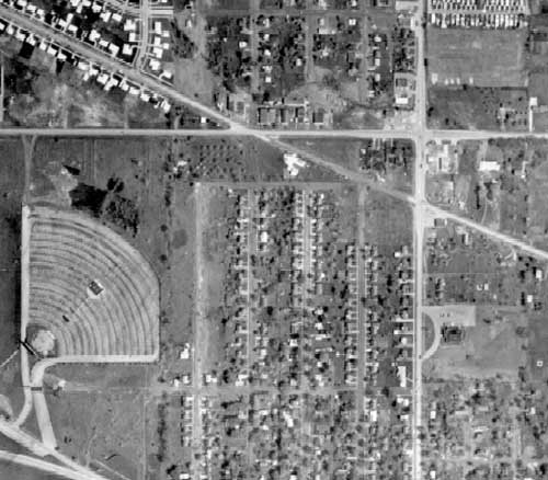
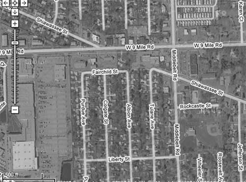
| | Posted on Friday, October 19, 2007 - 12:00 pm: | |
Shiawassee at 9 & Middlebelt
|
Abracadabra
Member
Username: Abracadabra
Post Number: 152
Registered: 04-2007
| | Posted on Friday, October 19, 2007 - 1:39 pm: | |
Leland, that is an awesome shot of the old drive-in as well, thanks! |
Catman_dude
Member
Username: Catman_dude
Post Number: 243
Registered: 03-2006
| | Posted on Friday, October 19, 2007 - 2:15 pm: | |
Oh, so that is what that was, a drive-in. I thought it looked like a Greek amphitheater-type of place. lol |
Johnlodge
Member
Username: Johnlodge
Post Number: 3173
Registered: 10-2003
| | Posted on Friday, October 19, 2007 - 2:51 pm: | |
From Fareastsider's link regarding the Card Rd. Bridge.
"When I first discovered this bridge, it had clearly been closed for at least a decade (The actual time is over 20 years). I figured that the bridge was probably not going to be restored, yet I figured I could enjoy the bridge in its current state for years to come. How silly of me to think that I could take a truss bridge for granted! Read this article that I found on the Internet from the Detroit News. Not only is this historic truss bridge doomed, they want to replace it with the highly overrated type of bridge known as a covered bridge. This is not going to be an old bridge moved here, it is going to be a non-historic, 21st century covered bridge. This is a pathetic idea that disgraces not only truss bridges, but covered bridges as well."
The News article link is gone, but what an odd plan that was. Anybody remember that? |
Fareastsider
Member
Username: Fareastsider
Post Number: 639
Registered: 08-2006
| | Posted on Friday, October 19, 2007 - 3:10 pm: | |
Here are a few around Macomb County.
Here is one Called Bade Rd which used to run from Omo rd to New Haven road.
http://maps.google.com/maps?hl =en&q=bade+%26+Omo+Lenox+Towns hip+michigan&um=1&ie=UTF-8&sa= N&tab=wl
Here it is in 1949 at the top of the picture.
http://techtools.culma.wayne.e du/media/macomb/1949/ha-20-105 .pdf
Here is a Road called Kidder Road in Bruce Twp. Here at its southern intersection with Van Dyke it used to continue in a zig zag fashion east of Van Dyke to McKay road. I have it clearly seen on a map but my scanner is down. Here is where it is today.
http://maps.google.com/maps?hl =en&q=78000+van+dyke+road+bruc e+township+michigan&um=1&ie=UT F-8&sa=N&tab=wl
Here you can see the small road continuing east probably a old farm access.
http://techtools.culma.wayne.e du/media/macomb/1949/ha-3-97.p df
Baker Road in Chesterfield used to run to 26 Mile road but now ends 1/2 south due to I94
http://maps.google.com/maps?hl =en&q=hobarth+%26+Baker+road+C hesterfield+township+michigan& um=1&ie=UTF-8&sa=N&tab=wl
In fact from 23 Mile road north I94 actually runs at such an angle it hits alot of the intersections of rural roads in the grid pattern. Follow it north to see the number of roads dead ended by the road and routed at goofy angles to get access to other roads. |
Fareastsider
Member
Username: Fareastsider
Post Number: 640
Registered: 08-2006
| | Posted on Friday, October 19, 2007 - 3:25 pm: | |
Shiawassee also seems to have been hacked up for this subdivision. http://www.cis.state.mi.us/pla tmaps/dt_image.asp?BCC_SUBINDE X=37318
Shiawassee can be seen here going to Telegraph in 1949.
http://techtools.culma.wayne.e du/media/wayne/1949/ha-17-40.p df
Here is the subdivision when it was recently completed. Probably one of the last ones in the city for a while. That sub is one of the rare ones that has the distinct suburban feature of the back yards along the main road. |
Abracadabra
Member
Username: Abracadabra
Post Number: 154
Registered: 04-2007
| | Posted on Friday, October 19, 2007 - 4:53 pm: | |
Fareast, nice one. It appears that when that sub went in, that area was sub-urban. Look at all of those farms! That map has a nice shot of Imperial Hwy as well. That area now :
http://maps.google.com/maps?hl =en&q=78000+van+dyke+road+bruc e+township+michigan&ie=UTF8&ll =42.438027,-83.274951&spn=0.01 6976,0.046649&t=h&z=15&iwloc=a ddr&om=1 |
Abracadabra
Member
Username: Abracadabra
Post Number: 155
Registered: 04-2007
| | Posted on Friday, October 19, 2007 - 5:04 pm: | |
It looks like there was a round-about at W. Chicago and Inkster.
http://techtools.culma.wayne.e du/media/wayne/1949/ha-17-25.p df
It is now used as ramps. I always wondered why they felt the need to use ramps at that intersection.
http://maps.google.com/maps?hl =en&q=78000+van+dyke+road+bruc e+township+michigan&ie=UTF8&t= h&om=1&ll=42.365488,-83.306494 &spn=0.016996,0.046649&z=15&iw loc=addr |
Fareastsider
Member
Username: Fareastsider
Post Number: 660
Registered: 08-2006
| | Posted on Friday, November 02, 2007 - 11:57 am: | |
I just noticed Snow appears to be vacated east of Southfield. Lost in that new large shopping center. I find it Funny they use the new space built for the store as a large truck area and wont even keep the road in when there is room to direct the large trucks away from the sight. If I remember correctly the road was a small useless road anyways. Snow is an odd street in Dearborn. |
Lopsidedfrock
Member
Username: Lopsidedfrock
Post Number: 2
Registered: 08-2007
| | Posted on Friday, November 02, 2007 - 1:25 pm: | |
Pardee Rd in Taylor appears to be rerouted.
http://maps.google.com/maps?f= q&hl=en&geocode=&time=&date=&t type=&q=pardee,+taylor&sll=42. 198703,-83.257785&sspn=0.01392 5,0.029182&ie=UTF8&ll=42.19930 7,-83.260531&spn=0.013925,0.02 9182&t=h&z=15&om=1 |
Trainman
Member
Username: Trainman
Post Number: 550
Registered: 04-2006
| | Posted on Saturday, November 03, 2007 - 9:58 am: | |
Empty roads and poor management of our limited tax dollars were the real problems of keeping the Livonia SMART buses.
The Livonia city council's plans to give themselves pay raises by talking about empty buses worked. But it was not true The former SMART Middlebelt Road Route 285 had many full buses.
State leaders propose slashing state matching funds for buses from 20 percent to 13 percent to get federal transit grants to help balance the state budget. This non-sense should be stopped. Or, we will pay even more local and county tax increases and could lose even more jobs as a result. The Livonia opt out is proof of this. Please, DY’ers if any of you care about the handicapped then write your leaders and tell them to stop cutting off state matching funds for buses and the community handicapped/senior citizens vans. Our leaders already cut operating funds. Our leaders cry because they want more and bigger roads and they tell you all that we all need them. If someone wants a bigger road then they should pay for them themselves or raise taxes themselves and not take away the money from a handicapped bus or van to pay for them. |
Japes
Member
Username: Japes
Post Number: 33
Registered: 02-2007
| | Posted on Wednesday, November 07, 2007 - 5:23 pm: | |
Sibley/Dix(Detroit-Toledo HWY)/I-75. I -75 just starts at Sibley at the bottom of the map, Allen and Pennsylvania is a traffic circle and the newly build Detroit-Toledo Hwy bridges are open over Allen and Pennsylvania
http://techtools.culma.wayne.e du/media/wayne/1961/fm-22-62.p df
http://maps.google.com/?ie=UTF 8&ll=42.176572,-83.231478&spn= 0.03104,0.079823&t=h&z=14&om=1
Fareastsider - I always found it odd that the bridge over Southfield was built at Fern and not at Snow, before you could turn off outer drive and cut behind the hospital(VA) and into the sub -- Snow was decom when the hospital was still there in the mid 80's,though once the freeway was built it cut off the path from Outer Drive and really had no purpose other than to service the hospital parking lots. |
Yeti
Member
Username: Yeti
Post Number: 8
Registered: 09-2007
| | Posted on Thursday, November 08, 2007 - 10:32 pm: | |
This one always gets me, super nice, smooth 5 lane road, that just stops.
http://maps.google.com/maps?f= q&hl=en&geocode=&time=&date=&t type=&q=S+Huron+Rd,+new+Boston ,+mi&sll=42.137994,-83.376548& sspn=0.001862,0.005021&ie=UTF8 &ll=42.137878,-83.378109&spn=0 .003723,0.010042&t=h&z=17&om=1
Thats in New Boston, south of Metro |
Hornwrecker
Member
Username: Hornwrecker
Post Number: 1926
Registered: 04-2005
| | Posted on Thursday, November 08, 2007 - 10:49 pm: | |
I forgot about something I posted in an old thread about Royal Oak Twp. On a map I have from the 1930s, it shows a road (Sunset) connecting the two disjointed parts of the township, from 8 Mile Rd (west of Wyoming) to Greenfield (north of 10 Mile).
On the map from the mid 60s, it shows two to three unconnected parts of Sunset.
On newer maps, only one short segment of Sunset survives.
(Message edited by Hornwrecker on November 08, 2007) |
Jerrytimes
Member
Username: Jerrytimes
Post Number: 62
Registered: 04-2007
| | Posted on Thursday, November 08, 2007 - 11:29 pm: | |
That is something very interesting that I've never seen before. I've always wondered why Royal Oak Twp. was two seperate areas. It never made sense. |
Hornwrecker
Member
Username: Hornwrecker
Post Number: 1928
Registered: 04-2005
| | Posted on Thursday, November 08, 2007 - 11:39 pm: | |
They were leftover pieces of the original twp, while the areas surrounding them were incorporated into towns and cities. Do a search for ROT on this site, and there's a thread that goes into more detail/
If anyone wants to search for other unbuilt roads, here's a link to the 1930s map that I scanned (totals 51 Mb):
http://picasaweb.google.com/Ho rnwrecker/1930sDetroitMap |
Novine
Member
Username: Novine
Post Number: 235
Registered: 07-2007
| | Posted on Friday, November 09, 2007 - 11:00 am: | |
Same reason that Brownstown is in three pieces, annexation and incorporation of most of the township leaving the remnants behind. |
Tayshaun22
Member
Username: Tayshaun22
Post Number: 380
Registered: 02-2005
| | Posted on Friday, November 09, 2007 - 11:10 am: | |
Yeti, if you imagine correctly, you can see how South Huron would turn 90 deg. right after the expressway. Then it follows various trails throughout Willow towards the entrance to Oakwoods. I believe that before the parks were there, this road existed. There is a cemetery in the middle of nowhere in Willow, but it would run right along the imagined South Huron Rd. |
Fareastsider
Member
Username: Fareastsider
Post Number: 682
Registered: 08-2006
| | Posted on Thursday, November 15, 2007 - 12:37 am: | |
Mayer Road @ 26 Mile the pic will tell you where....
http://i141.photobucket.com/al bums/r50/fareastsider/Ira%20Tw p%20Michigan/IraTwp3-3.jpg |