 
Ookpik
Member
Username: Ookpik
Post Number: 339
Registered: 01-2007
| | Posted on Tuesday, October 09, 2007 - 8:33 am: |    |
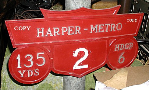
Does anyone remember the Harper - Metro Golf Course? Where was it exactly? When did it operate? What is built over it? I have had this sign for years and have never known much about it.
Ookpik |
Gistok
Member
Username: Gistok
Post Number: 5499
Registered: 08-2004
| | Posted on Thursday, October 11, 2007 - 10:59 pm: | |
OK, since no one has spoken up here...
The only golf courses that I know of that are anywhere near Harper Ave. (I'm assuming that the golf course name refers to the street) are the Chandler Park Golf Course, and the St. Clair Shores Golf Course (on 13 1/2 Mile (Masonic) between Harper and Little Mack (starting about 2 blocks west of Harper). Could one of these 2 courses ever been called that name?
There also used to be a golf course (don't know the name of it) north of 8 Mile between Kelly & Gratiot in Eastpointe (then East Detroit)... but that one is about 1 1/2 miles from Harper Ave. It was turned into subdivisions in the 1950's.
The Lochmoor and Country Club of Detroit golf courses in the Grosse Pointes were never call "Harper-Metro".
That's all I know... |
Ookpik
Member
Username: Ookpik
Post Number: 340
Registered: 01-2007
| | Posted on Thursday, October 11, 2007 - 11:53 pm: | |
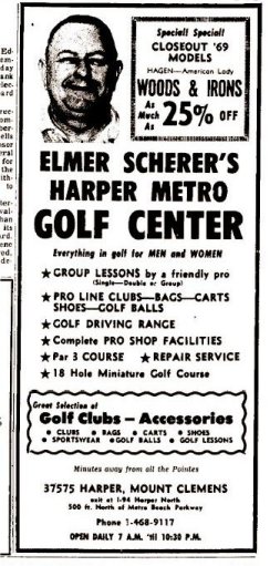
It took some time but I was able to figure this one out. The golf course was indeed on Harper - 37575 Harper to be exact - but in Mt. Clemens, not Detroit! An apartment complex appears to have been built over the course sometime in the late 1970's or early 1980's. I have yet to speak to anyone who even has the vaguest memory of the course. Anyway, here is a 1970 advertisement for the course:
Ookpik |
Mikem
Member
Username: Mikem
Post Number: 3497
Registered: 10-2003
| | Posted on Friday, October 12, 2007 - 12:35 am: | |
Apparently it was a golf "center" with only a Par 3 course. An aerial view from 1961 shows only the driving range and miniature course:

A few other courses in the area have disappeared over the years. Other than the ones Gistok mentioned were the: Renmore - a public course on the south side of the Lochmoor CC; the St Clair Shores CC at Masonic & Jefferson (the current SCS CC was formerly the Lakepointe CC); and the Fairway GC at 10 & Kelly. The course on 8 Mile was called the Ridgemont Golf Club.


|
Hpgrmln
Member
Username: Hpgrmln
Post Number: 212
Registered: 06-2007
| | Posted on Friday, October 12, 2007 - 7:24 pm: | |
I knew where it was the minute I saw the heading-
Haper and 16 mile AKA Metro Parkway. Now known as Clinton Twp. According to the numbering system, that should be around Neil reid park...Somewhere between Denton and wellington Crescent. |
Johnlodge
Member
Username: Johnlodge
Post Number: 3053
Registered: 10-2003
| | Posted on Friday, October 12, 2007 - 7:43 pm: | |
Mack turns into "Union Lake Road" on that first map. I'm not sure why that area's dashed, perhaps it was proposed or under construction when the map was printed. |
Mikem
Member
Username: Mikem
Post Number: 3498
Registered: 10-2003
| | Posted on Friday, October 12, 2007 - 8:00 pm: | |
It was dashed because it was still gravel. Map is circa 1935.
Also, there was another course at the southeast corner of Masonic & Little Mack, Sunny Acres, across from the former Gratiot Drive-In. |
Bobj
Member
Username: Bobj
Post Number: 2503
Registered: 11-2003
| | Posted on Friday, October 12, 2007 - 10:53 pm: | |
Used to be a lot more golf courses, I guess the land was too valuable at some point |
321brian
Member
Username: 321brian
Post Number: 469
Registered: 02-2006
| | Posted on Friday, October 12, 2007 - 11:28 pm: | |
It is now condos and a CVS strip mall. |
Taj920
Member
Username: Taj920
Post Number: 258
Registered: 01-2004
| | Posted on Saturday, October 13, 2007 - 10:38 am: | |
Duflo Road on one map must be the current Beaconsfield? |
Gistok
Member
Username: Gistok
Post Number: 5509
Registered: 08-2004
| | Posted on Saturday, October 13, 2007 - 4:16 pm: | |
Hmmm... Mack (Greater Mack) does several zigzags thru St. Clair Shores. I always thought it ended at Masonic (13 1/2 Mile), now I'll have to explore the northern reaches of SCS and Clinton/Harrison Townships to see if it does continue northward.
That map shows old 16 Mile (today Metro Parkway) only going as far east as Gratiot (just above the US25 sign). The stretch of that road east of Gratiot must have been built around the same time as Metro Beach Metropark.
Also interesting is that Harper Ave. is shown as Mt. Clemens Dr. from Morang (in Detroit) to somewhere in SCS, then it shows as Harper Ave. again, and north of SCS it shows it as Mt. Clemens Dr. again. |
Fareastsider
Member
Username: Fareastsider
Post Number: 624
Registered: 08-2006
| | Posted on Sunday, October 14, 2007 - 1:11 pm: | |
It seemes that Greater Mack has been broken up over time. |