Mikeg Member Username: Mikeg Post Number: 1188 Registered: 12-2005 |
I recently came across a brochure that was handed out at the 1967 dedication of the Chapaton Retention Basin, which is located at the northeast corner of Nine Mile Rd. and Jefferson in St. Clair Shores. At the time, the Macomb County Drain Commissioner, Tom Welsh, apparently had an "Island Study" underway, which envisioned building a causeway from the foot of Nine Mile Road to a man-made island that would be created on an existing off-shore sandbar in Lake St. Clair to provide additional public lake access for recreational purposes. The island's dimensions would have been about one-half mile long by one-quarter mile wide. Obviously, this ambitious idea never happened - perhaps it was too expensive or maybe they couldn't get the necessary Army Corps of Engineers permits? Here is the description of the "Island Study" that appeared in the brochure: The Island pictured here is presently an idea, but it also is an attainable reality. Throughout the nation, such manmade water access playgrounds have been successfully constructed, and more of them are currently underway. Here we have a causeway in being leading to a sandbar section of Lake St. Clair, an ideal location. Much groundwork necessary to the actual start of island construction already has been done. The need for additional lake access for thousands of Macomb County residents is pressing, and this Island is a feasible and practical answer to that need. Here are perspective and plan view sketches of the proposed island plus a location map which were all included in the brochure: 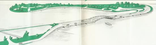 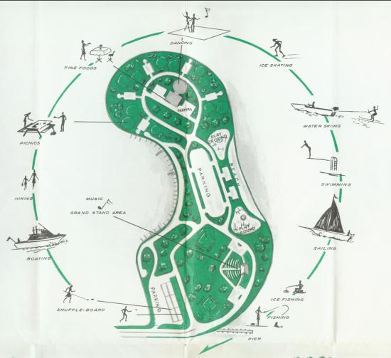 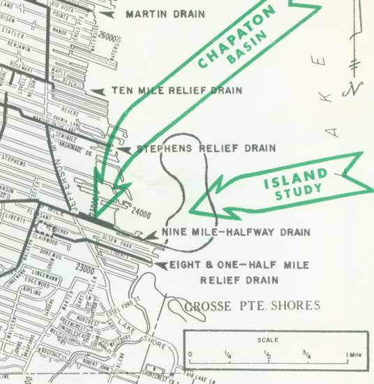 | ||
Fareastsider Member Username: Fareastsider Post Number: 598 Registered: 08-2006 |
There were even plans to run 16 mile out to the flats and have dozens of interconnected manmade islands troughout the lake with about 5000 homes in the 1950s. It was just a plan by a very rich man. Anyone else ever hear of that? Very interesting by the way. (Message edited by fareastsider on September 19, 2007) | ||
Mbr Member Username: Mbr Post Number: 231 Registered: 03-2005 |
I recall an article in the mid '90's in the Free Press about one guys plan to extend Vernier out into the lake and have many islands branch off with residential development. Anyone remember that? | ||
El_jimbo Member Username: El_jimbo Post Number: 332 Registered: 12-2006 |
Fareastsider, What would they have done about the shipping traffic? | ||
Fareastsider Member Username: Fareastsider Post Number: 600 Registered: 08-2006 |
probably the same thing im talking about I read the same article. It had 16 and 8 mile running out and probably another road | ||
Soomka1 Member Username: Soomka1 Post Number: 39 Registered: 02-2007 |
Just think what an Island right off of Nine Mile with those amenities would have done for St. Clair Shores? I would love to see who opposed the idea and how close it came to happening. | ||
Jimaz Member Username: Jimaz Post Number: 3304 Registered: 12-2005 |
(With tongue only halfway in cheek: ) This is another advantage Michigan has over landlocked states. We have an option to expand geographically. Of course, if lake levels keep dropping that will happen naturally anyway. | ||
Tponetom Member Username: Tponetom Post Number: 146 Registered: 06-2007 |
Tom Welsh? Drain Commissioner of SCS, in the Fifties? Very, very powerful figure in the expansion of SCS in those days. (Brother of Marv Welsh, I think) | ||
Taj920 Member Username: Taj920 Post Number: 255 Registered: 01-2004 |
Tom Welsh was a powerful guy; the Mayor of SCS in the 50s. He forced MDOT to make I-94 go around the heart of the city along Harper. That's why there is the big curve on I-94 at 8 Mile. | ||
Gistok Member Username: Gistok Post Number: 5371 Registered: 08-2004 |
That explains why I-94 is the "moat" or border that separates St. Clair Shores from Eastpointe and Roseville. That island park idea seems very cool indeed. I remember as a young child going to the 9 Mile & Jefferson beach back before they closed it for the Chapaton storm drain project. Of course had it been built, it would likely today be a private SCS park, just like the neighboring Grosse Pointe Woods Park, which is along the SCS shoreline, and an irritant for SCS, to be sure! I bet the Army Corps of Engineers did put a kabosh on the island park. | ||
Gistok Member Username: Gistok Post Number: 5372 Registered: 08-2004 |
One other point.... shipping traffic... the dredged shipping channels are way out in Lake St. Clair, at least 3 miles from this proposed island. | ||
Fareastsider Member Username: Fareastsider Post Number: 601 Registered: 08-2006 |
They are also near the border. The islands were all in American waters. The freighters have their own dredged channel. | ||
Jasoncw Member Username: Jasoncw Post Number: 441 Registered: 07-2005 |
Cool plans! | ||
Ejr Member Username: Ejr Post Number: 2 Registered: 09-2007 |
My dad and my grandparents remember Jefferson Beach amusement park. It closed before the island proposal. The internet remembers too and provided a nice link (some nice pics from then): http://www.waterwinterwonderla nd.com/amuse.asp?id=310&type=2 More recently, there was a plan to build some hotels and beachfront there for bringing in tourism and to get some of the convention traffic from Detroit. I'm sure the plans are at least 10 years old, but I didn't find what I was looking for. I think this is the group that was planning that: http://www.one-water-place.com /index.php (link to their current website) (Message edited by Ejr on September 20, 2007) |